magpie patrick Posted May 4, 2023 Report Share Posted May 4, 2023 4 minutes ago, Pluto said: There is one more, and you cannot see the (official) Sankey, only the St Helens Canal, the later extension of the Sankey down to Widnes. The one more is the Runcorn and Latchford I think Link to comment Share on other sites More sharing options...
___ Posted May 4, 2023 Report Share Posted May 4, 2023 8 minutes ago, magpie patrick said: The one more is the Runcorn and Latchford I think A canal I wasn’t aware of until just now. Is it between the Mersey and the MSC or south of the MSC? Link to comment Share on other sites More sharing options...
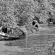
Pluto Posted May 4, 2023 Report Share Posted May 4, 2023 Yes, the Runcorn & Latchford, which was built over in Runcorn when the MSC was built. You can see the line leaving the MSC to the left just above the loop in the river. From there, there used to be quite a lot still visible, though I have not looked recently. It joined the MSC again by Walton Lock, where there is a section still in water on Google maps. A photo of the R&LC in 1977, and a map of the M&IN from circa 1880 showing the route of the R&LC. Link to comment Share on other sites More sharing options...
cuthound Posted May 4, 2023 Report Share Posted May 4, 2023 (edited) 13 hours ago, Captain Pegg said: And I thought you were a southerner who braved a move to the 'north'. Born in the north, lived for 52 years in the south and retired to the midlands for 9 years so far. Edited May 4, 2023 by cuthound Clarification Link to comment Share on other sites More sharing options...
Heartland Posted May 4, 2023 Author Report Share Posted May 4, 2023 Ariel views are often of interest, a Plutos asked questions about how many canals and a debate about the Mersey & Irwell as well as the Sankey Brook Navigation As to my question, Yes it was Blowers Green pump house as designed by G R Jebb and built beside the deep lock. Link to comment Share on other sites More sharing options...
beerbeerbeerbeerbeer Posted May 4, 2023 Report Share Posted May 4, 2023 23 hours ago, Heartland said: Has anybody worked out where the rowing boat is? And yes it is a ferry across the Harbour, near this spot was a dock for somewhat larger ferries that used to go to the only part of Britain occupied by the Germans. There’s a choice of several harbours that might fit. I’ll opt for what’s likely to be the smallest harbour and say Weymouth. Link to comment Share on other sites More sharing options...
Heartland Posted May 4, 2023 Author Report Share Posted May 4, 2023 Yes, Weymouth That was where the GWR and Sealink Boats sailed from to the Channel Islands. Sadly Condor moved their service to Poole. Now in a link to Plutos post where is this? Link to comment Share on other sites More sharing options...
Heartland Posted May 5, 2023 Author Report Share Posted May 5, 2023 No takers? The winch would have been used to assist barges into the lock on the Mersey & Irwell, Navigation, but which part was it? Another cryptic clue - a fighting place. Link to comment Share on other sites More sharing options...
___ Posted May 5, 2023 Report Share Posted May 5, 2023 6 hours ago, Heartland said: No takers? The winch would have been used to assist barges into the lock on the Mersey & Irwell, Navigation, but which part was it? Another cryptic clue - a fighting place. Warrington? Link to comment Share on other sites More sharing options...
Heartland Posted May 6, 2023 Author Report Share Posted May 6, 2023 YES VERY GOOD, again War ing Town and this winch was at the end of the Woolston Cut It would be of interest to know its purpose, I assumed that the winch assisted barges into to the lock when the flow down stream warranted it, but it would be useful to hear of other opinions. Link to comment Share on other sites More sharing options...
billh Posted May 6, 2023 Report Share Posted May 6, 2023 There was a similar winch at the tail of the bottom Hulme lock in Manchester. The lock was at right angles to the river Irwell and the winch was used to haul boats out of the lock and into the Irwell stream where a tug would pick up the tow for the journey into Manchester docks. On one occasion , the lock staff were over enthusiastic with the winching and fired a loaded wooden narrowboat at great speed into the opposite bank of the river with such force that the stem was burst and the boat sank. Compensation set in and the MSCC had pay for recovery and repair of the casualty. Link to comment Share on other sites More sharing options...
Ronaldo47 Posted May 6, 2023 Report Share Posted May 6, 2023 (edited) Old Ford Locks on the Lee and Stort (and presumably others in the area) had a powered capstan for pulling lighters into the lock, to be removed by the tug. It was common for a tug to pull a train of three lighters, and after the first, the others would be sequentially attached to the end of the train as they were locked through. Photos from 1968. Edited May 6, 2023 by Ronaldo47 typo 2 Link to comment Share on other sites More sharing options...
magnetman Posted May 6, 2023 Report Share Posted May 6, 2023 Powered capstans at Brentford gauging locks, Commercial road lock on the Regents section of the Grand Union also had one. There is also an amazing old powered capstan on the old coal loading wharf for Kingston power station.. Lovely old hardware these things are. Brentford Commercial Road Lock And The Beast at Kingston power station former coal delivery wharf. 1 Link to comment Share on other sites More sharing options...
Pluto Posted May 7, 2023 Report Share Posted May 7, 2023 Going back to the Woolston Lock winch, this was for the New Cut and was a little above the weir for the original Woolston Lock. Looking at old plans, the M&IN had several locks which left the river at right-angles immediately above the associated weir. It must have been a bit of a nightmare in flood conditions, and certainly explains why a modernised navigation was proposed as early as the 1820s, even before railway competition. The M&IN could be seen as the only early 'industrial' navigation which was not modernised in the century after they opened. The A&CN had to be improved in the 1770s, the Douglas was bypassed by 1781, and though I haven't checked the dats, I suspect that the Weaver and Don were also altered, as was the Newry in Ulster. It is easy to forget the dramatic increase in trade brought about by inland waterways, and systems which could cope in the early to mid 18th century had become too unreliable for traffic at the end of the century. Link to comment Share on other sites More sharing options...
Heartland Posted May 7, 2023 Author Report Share Posted May 7, 2023 Some interesting thoughts presented by Pluto. Now for some easier may be? Link to comment Share on other sites More sharing options...
beerbeerbeerbeerbeer Posted May 7, 2023 Report Share Posted May 7, 2023 Walsall Basin Link to comment Share on other sites More sharing options...
Pluto Posted May 7, 2023 Report Share Posted May 7, 2023 This photo is looking down on what would have been the terminus of a canal proposed in 1780, but never built. Coal mining, the reason for the proposed canal, took place here until the 1930s. Link to comment Share on other sites More sharing options...
Heartland Posted May 7, 2023 Author Report Share Posted May 7, 2023 Who suggested an aqueduct at Whalley by the way? Link to comment Share on other sites More sharing options...
Jen-in-Wellies Posted May 7, 2023 Report Share Posted May 7, 2023 1 hour ago, Pluto said: This photo is looking down on what would have been the terminus of a canal proposed in 1780, but never built. Coal mining, the reason for the proposed canal, took place here until the 1930s. It is Ingleton. Many a misspent weekend of my youth staying in those caravans under the viaduct, while caving in the surrounding hills. The proposed canal is a new one to me. Link to comment Share on other sites More sharing options...
Pluto Posted May 7, 2023 Report Share Posted May 7, 2023 This is a plan I found in the Yorkshire Archaeological Society's archive. The canal would have joined the River Greta to the west as a link to Lancaster, and running to Settle, and the proposed Settle Canal in a more southerly direction. The long tunnel at Giggleswick would have been under the ridge of ground Giggleswick School is built upon, with side canals into any coal measures they found. The second photo is of the site for the proposed Whalley aqueduct, looking from Great Harwood towards Clitheroe and the Ribble Valley. Proposed in John Longbothom's initial survey for the canal, it could easily have been 80 feet in height according to how you interpret the final 1770 canal survey. Work did start, but was quickly abandoned because of cash flow. The 1790 proposed route for the canal would have avoided it, with the canal running on the south side of the River Calder, with the present, more southerly, line being agreed in 1794. 1 Link to comment Share on other sites More sharing options...
Heartland Posted May 9, 2023 Author Report Share Posted May 9, 2023 Goliath did correctly identify Walsall Basin as it became. It would be nice to see more events like this there. It is far different from the original terminus of the Walsall Canal. John Rennie Senior did propose an extension from here to Rushall, but that scheme was not proceeded with. Link to comment Share on other sites More sharing options...
beerbeerbeerbeerbeer Posted May 10, 2023 Report Share Posted May 10, 2023 (edited) here’s slightly different angle to the theme; What is it that cheat.civic.tune and fairly.panel.weedy have in common? Edited May 10, 2023 by Goliath Link to comment Share on other sites More sharing options...
magpie patrick Posted May 10, 2023 Report Share Posted May 10, 2023 18 minutes ago, Goliath said: here’s slightly different angle to the theme; What is it that cheat.civic.tune and fairly.panel.weedy have in common? They are locations where the really serious BCN canal basher bashes their stem post into the masonry and declares they "got as far as we can go down the XXXX branch...." But I'm sure there's more to it than that! 1 Link to comment Share on other sites More sharing options...
Rob-M Posted May 10, 2023 Report Share Posted May 10, 2023 1 hour ago, Goliath said: here’s slightly different angle to the theme; What is it that cheat.civic.tune and fairly.panel.weedy have in common? Were they once joined up in a loop as one is the end of canal at the top of farmer's bridge and the other the end of canal in gas street. Link to comment Share on other sites More sharing options...
David Mack Posted May 10, 2023 Report Share Posted May 10, 2023 They are the furthest you can now get along the two original terminal branches of the Birmingham Canal. 6 minutes ago, Rob-M said: Were they once joined up in a loop as one is the end of canal at the top of farmer's bridge and the other the end of canal in gas street. No. The Gas Street branch ended up in twin arms the other side of Bridge Street, with the BCN headquarters building beyond fronting onto Paradise Street. From Cambrian Basin there were various arms and branches. 2 Link to comment Share on other sites More sharing options...

Featured Posts
Create an account or sign in to comment
You need to be a member in order to leave a comment
Create an account
Sign up for a new account in our community. It's easy!
Register a new accountSign in
Already have an account? Sign in here.
Sign In Now