Pluto
-
Posts
4,518 -
Joined
-
Last visited
-
Days Won
2
Content Type
Profiles
Forums
Events
Gallery
Blogs
Store
Everything posted by Pluto
-
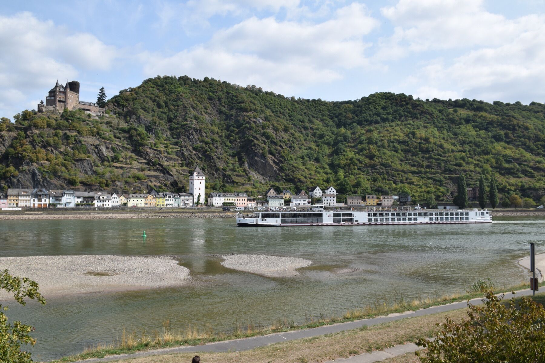
Water Shortage - not just the leisure network
Pluto replied to magpie patrick's topic in General Boating
The Rhine was pretty low in 2018, with loads much restricted.
-
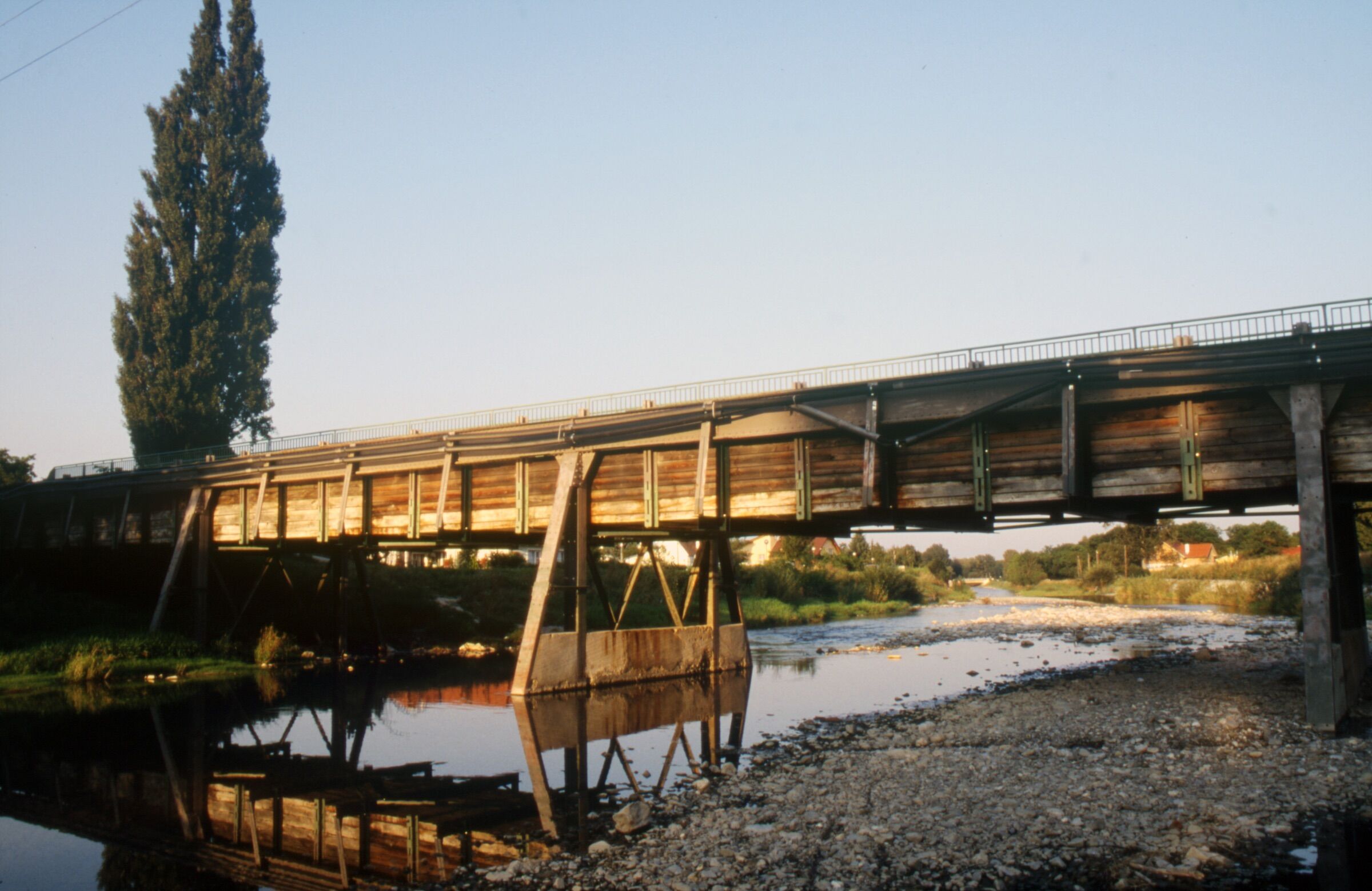
New Aqueducts - especially as part of restoration
Pluto replied to magpie patrick's topic in History & Heritage
The Schwechat Aqueduct on the Wiener Neustadt Kanal, seen here in 2002. The canal was partially restored for powering turbines in some of the locks.
-
I go to both as I have been assessed for new shoulder joints which are usually done at Halifax. Having just moved from Barnoldswick and the care of Blackburn/Burnley hospitals, they do seem to be more organised and progressive in Calderdale. And my new GP practice seems MUCH more responsive.
-
That's what comes of living in a hotbed of non-conformism, where they take their religion seriously. I must take a bible with me when I go for physio at Huddersfield Royal tomorrow!
-
Don't bother looking at church pews re a bed-hole, as the pews were designed to keep you awake. Sermons in Victorian times tended to be somewhat long.
-
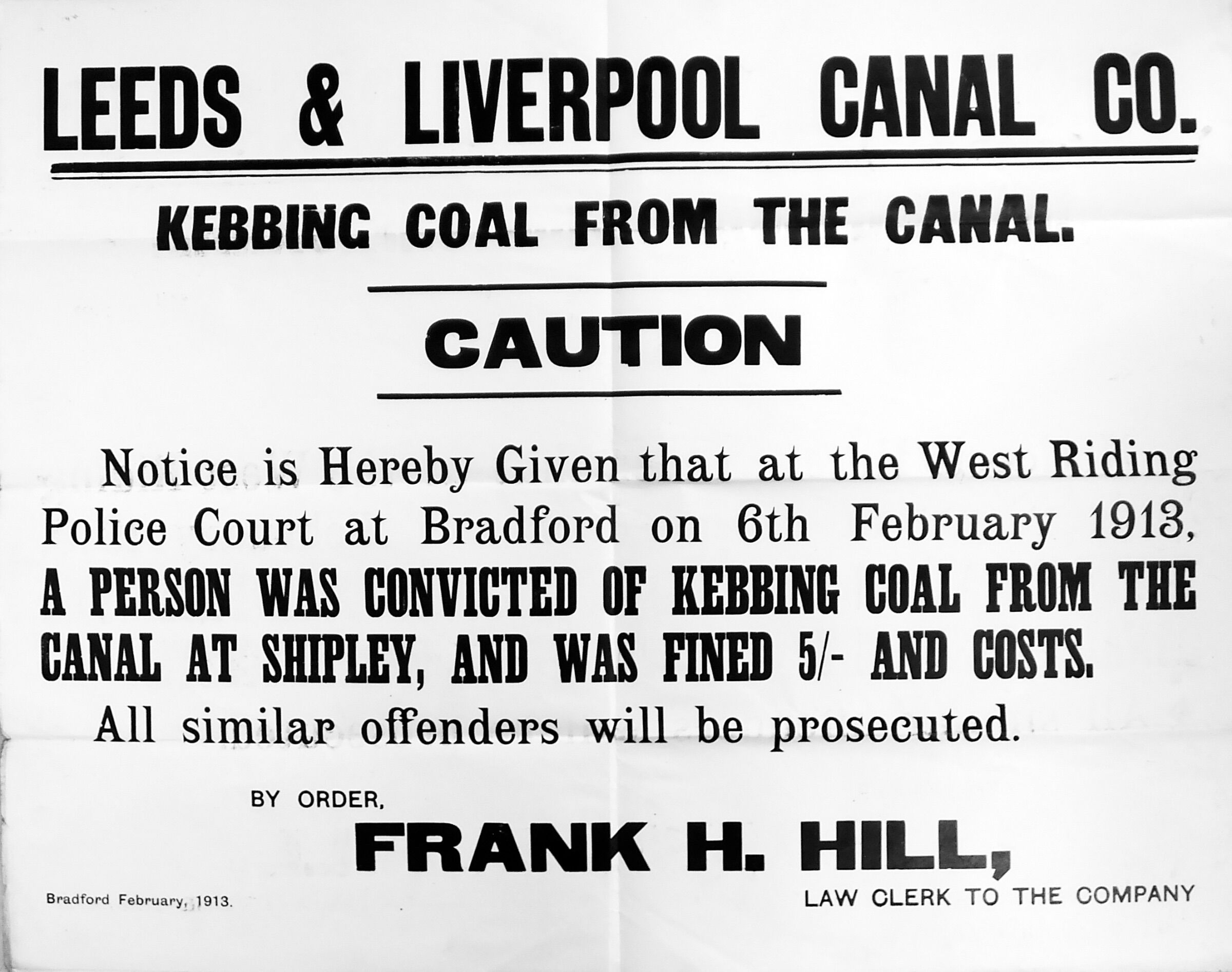
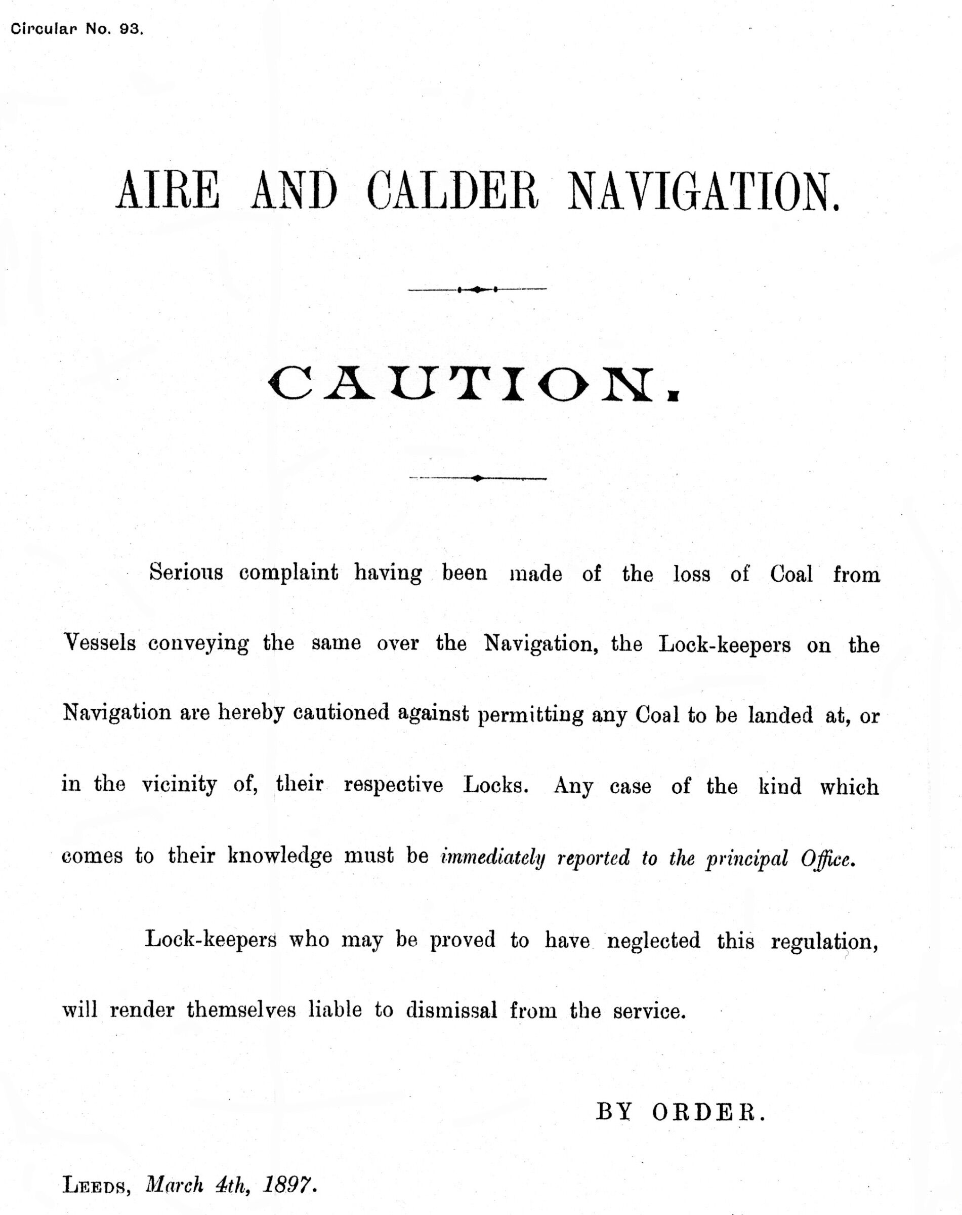
I have come across several prosecutions by the L&LC re coal, and the A&CN must have been at it as well.
-
Very little written paperwork has survived, and the researcher has to rely upon transcriptions or printed material. One of the best canal archives is that for the Rochdale Canal, and though I have not been through that thoroughly, I found very little when looking for material relevant to paddle gear changes. As someone who has looked at archive material over many years, I am always wary of anyone suggesting it 'must' survive, without giving any useful examples. As I suggested earlier, I have found both sill and cill used in canal records of all types, so there is no specific spelling. I have attached the text of a report by someone spying on the Sankey coal trade for the L&LC in 1816, which a rare example of poorly spelt text I have found amongst canal archives. 1816 Sankey coal inspection. by L&LC.pdf
-
We are talking about a time when work was done by craftsmen supervised by management who had often worked on the tools. No one year contracts then, with many workers whose family had worked on the canal for generations. As with many such skilled jobs, the spoken word was the norm and, with poor quality education, many people then could probably be called dyslectic today.
-
Having done extensive historical research into lock and lockgate construction, I can safely say that both versions, 'sill' and 'cill', appear in drawings and notes produced by canal maintenance men throughout the 19th and 20th century. Try as I might, I could not find any particular reason for either spelling. There is very little 18th century material, and when it comes to detailed canal engineering there are really only European books, such as Belidor's Architecture Hydraulique, with nothing definitive on canal engineering in English. As a result, names would have been handed down by word of mouth, making variations highly likely, and names for specific details often differ from canal to canal. Have a look at my chapter in the HNBC booklet on canal heritage.
-
Is this a different Norton to Peter Norton whose book, Railways and Waterways of Warrington, was first published by the RCHS? He was certainly a friend of Edward Paget-Tomlinson.
-
Being able to allow for towing at an angle does seem to have been another factor. One boatman I knew said he had a horse which would move over to the edge of the towpath when told to gee-up, making further effort liable to pull the horse into the water. The solution was that when told to gee-up and the horse moved to the canal edge, a quick push would ensure the horse did fall in. It did not go near the edge again. Pulling a boat was a comparatively light occupation for a horse, which had to be used to pulling continually. One of the coal businesses on the L&LC bought horses from the Manx Tramway - when pulling a tram was getting a bit like hard work, the horse still had several useful years working on the canal.
-
The table doesn't transfer properly if I just paste from a Word document. The pdf downloads for me, so it must be you! The reference to market boats is a bit of a red herring, though they continued to operate on many canals well after packet boats finished. RAIL 844/243, pp274-275 Packet Boats v Fly Boats 30th March 1821 … I beg leave next to call the attention of the Committee to the Fly Boats and the Packet Hawlers. As to the Fly Boats, I feel very certain that they carry nearly as many Passengers as the Packets latterly. I have not mentioned the circumstances to the Bankrangers, but sometime ago I did to some of them and the reply was, that if information were laid by them, they should not consider themselves safe. I beg to state as my opinion that some Plan should be adopted to put down the carrying of Passengers by these Boats also submit to them at once. I cannot see any middle course. Respecting the hauling of the Packets, I am not aware of any serious cause of Complaint, except against Beesley of the Preston and who I believe generally loses from 15 to 20 minutes In going by the Packet I have often heard it regretted that a little more time was not allowed at Lancaster, now if they were compelled to keep time it might be done as under: Hours Mins Kendal to the Locks, including 6 minutes for the Tunnel 2 54 The Locks 0 45 The Locks to Lancaster 2 47 At Lancaster 0 30 The next stage, 15 miles including 4 minutes for the stoppage at Garstang 3 16 Thence to Preston 3 12 This would make it 24 minutes after seven when the Packet arrives at Preston, the arrival at Kendal would be about 10 minutes later in consequence of the Locks taking more time to fill than to empty. William Crossley 1860-3-23 market boat, RAIL 844/327 Preston, March 23, 1860. B P Gregson, Esq. Sir, I have frequently complained of the late arrival of the Market boat from Garstang, and I wish you would see John Birchall in order to have this rectified. Today the boat arrived at noon, and last week it arrived between nine and 10 in the fore noon. Now some of the potatoes have to be forwarded by train to other places for Saturdays market, and when the boat arrives late this cannot be done. I have repeatedly told the captain that they should come through to Preston without stopping, and then rest here. If they would do this, and get in by 7, 8 or half past 8 in the morning it would prevent many complaints, and they would always have a free course under the bridges before the coal trains began to arrive. You’re obedient servant John Green. 1873-10-31 market boat, RAIL 844/327 J. Greenall, Lancaster Canal, Preston, Oct 31, 1873. Mr J Slinger. Dear Sir, at the time I write (between 7 and 😎 the Market Boat has not turned up and from enquiries I have made it cannot get here before more morning. We have some at 4 or 5 tons for Garstang. The Progress got here light about 4 pm. I saw the Captain and he said his orders were to wait until tomorrow for his own cargo, and if it did not come, then he was to load for us. Half an hour after this I heard that Darlington had offered the Captain 5/- extra (my offer has been to the owners), and sought the Captain at once, and took him with me to Dewhurst Hoyle & Cos office. Mr Williamson at first would have repudiated any agreement, but afterwards acknowledged that owing to Thompson forwarding them so many loading he was obliged to withdraw his promise. I have seen Ashcroft’s book keeper today and also Henry himself and I have a promise of one perhaps two boats tomorrow. One boat has arrived, but it has to take manure as he is under a contract with Potter. I will telegraph when any boat is loaded for Bailie, but I am never safe until the cargo or part of it is loaded. Yours truly, J Greenall.
-
The Lancaster Canal Engineers reports do include the information people are looking for, as he gives the timetable. Note that he also differentiates between flyboats and packets. There is a specific use for each on northern canals. RAIL 844:243, pp274-275 Packet Boats v Fly Boats.pdf
-
A 1797 drawing of a Lancaster packet boat. RAIL 844/8/1
-
There are two comparatively recent books on this subject. Passenger Boats on Inland Waterways, D D Gladwin, Oakwood Press, 1979. Swifts & Queens, A I Bowman, Auld Kirk Museum Publications No 9, 1984.
-
John MacNeill's 1833 paper on the resistance of boats in water should answer most questions, as will the attached paper. 1835 T Grahame re canal boats.pdf
-
The term 'flyboat' may have had different meanings, depending upon the canal. Generally, it suggests a general cargo boat which had priority at locks, and often working to some sort of timetable. Reliability, rather than speed, was important. When it comes to speed, we are talking about 'packet boats', so-called because they were allowed to carry small packets, perhaps up to 56lb, as well as passengers. They usually operated in areas where there were long pounds and few locks. Considerable work was put into the design of the hull in the 1820s/30s, but the growth of rail traffic killed them off. The last on the L&LC worked between Burnley and Blackburn, but by 1840 it had become more of a pleasure boat, the owners claiming that as a mode of transport, the bar could be open throughout the trip.
-
Newry Canal - first cross watershed - which was second?
Pluto replied to magpie patrick's topic in History & Heritage
They tended to be promoted by those with colliery interests looking to enter the lucrative London market. -
Newry Canal - first cross watershed - which was second?
Pluto replied to magpie patrick's topic in History & Heritage
Europe's first summit level canal was the Stecknitzfahrt, joining the Elbe with the Baltic and opened in 1398. It is possible some of Britain's important northern Europe trade used the canal to avoid the excessive Danish charges for using the sea route passing Copenhagen. The Chinese built their first proper summit level on the Grand Canal around the same time after the Yellow River's exit to the sea had moved from the north of the Shandong peninsula to the south, around 500 miles. -
Work starts circa 1760, 1762 Batty Cut to be extended to above Hall Mill Dam; Ledgard Mill Cut to be lengthened 1764 Brindley becomes engineer; navigation opened up to Brighouse 1765 Brindley proposes extension to Sowerby; shoal dredged at Brooksmouth and canal completed to there. 1767 First flood damages, but quickly reopened to Salterhebble 1768 Second closure because of floods 1769 Open to Salterhebble 1770 Brighouse Old Cut, breaking of the banks; reopen to Sowerby 1776 Cut from Ledgard Bridge to Shepley Bridge opens and old Mirfield lock abandoned 1780 Bradley New Cut, Brighouse New Cut and Kirklees Cut to be built 1783 Brooksmouth locks altered 1785 Batty Cut extended 1791 Broad Cut to be surveyed; new Cooper Bridge Cut to be made 1797 Thornhill Cut from Horbury Bridge to Hostingley Lane to be built, replacing Dewsbury Cut 1805 Brighouse Cut extended to Freeman’s Mill 1812 Fall Ing Cut opened 1815 Elland Cut extended to Sowerby Cut 1822 Two locks at Brighouse instead of one 1823 Broad Cut extended 1828 Halifax branch opens 1835-8 Horbury New Cut, Broad Cut to Figure of Three, new lock at Thornes 1842 Kirklees Upper Lock to be lengthened 1861 Dewsbury arm sold to Lord Savile 1867 Batty Lock and Ledgard Bridge flood lock altered 1878 A&CN buy Dewsbury arm 1883 Fall Ing lock enlarged and one at Thornes lengthened; Broad Cut lower lock lengthened
-
Listings should not be relied upon for accuracy. I have been trying to get those covering the warehouses at Wigan corrected for over thirty years. I also wrote a report on one of the Goole swing bridges where the listing appeared to be more about the bridge which was replaced around 1910 than for the one I was looking at.
-
Two reasons for more connections to lateral rivers in mainland Europe. Firstly, there are a greater number of large rivers used as waterways, and secondly there was a much greater use of smaller rivers as navigations. Researching 18th century navigations around the Rhine brought up a number of rivers used by boats capable of carrying just a few tons.
-
The pier abutments look like they have had a major rebuild, with the face walls completely reconstructed, not entirely unexpected on surfaces exposed to river flow. The drawing, preserved in the Austrian State Archives, seems to have been the work of Clowes, and shows the Dove Aqueduct. It was given to Sebastian Maillard on his 1795 visit to England, and suggests he may have met Clowes.
-
Some details here re women on board in the 1840s: From: The Morning Chronicle, Dec 13th 1849 Labour and the Poor; The Manufacturing districts, Leeds I should devote a few words to the life and toil of the men, who, before the era of railroads, were chiefly concerned in the conveyance of heavy goods from place to place, and who still transport by water-carriage a very considerable portion of our manufactured and mineral wealth - I mean the bargemen engaged in navigating our inland canals. … The boats are long and narrow, and deeply laden. A tarpaulin covers the cargo stowed amidships, and sometimes in the bow, sometimes in the stern, sometimes in both bow and stern rise one or two funnels, the number being according to the size of the boat, smoking cheerily, and proclaiming that the cabins of captain and crew lie beneath. As a general rule, a single horse draws these boats along, the driver being frequently seated complacently upon its back, with both feet towards the water. This individual belongs to a class often talked of but seldom seen. In the slang of the canals he is called the Horse Marine. The marine is, indeed his regular trade appellation. Sometimes a man or a couple of men, lounge idly on the barge’s deck, occasionally a woman taking a trick at the helm is the only person visible. Let us descend into the after cabin of one of the larger class of barges, one carrying from 40-50 tons. It is a hot, choky, little box, between 4 and 5 ft high, near the scuttle is a stove. On either side run berths made after the usual fashion afloat. One is generally constructed broad enough to contain a couple of persons, the other often only room for one. Beneath them are lockers which serve for seats, and at the stern, just forward of the rudder opens the little cupboard, wherein the, sea-stock is deposited. Even with the scuttle open you will often find the air close and oppressive, but the captain will generally tell you that two, some three people sleep there with the hatch on. ‘We move it so as to make a chink, if we feel it over hot.’ The larger boats are normally navigated by a captain and two mates, and helped, of course by the marine. The average wages of the captain amounts to about 22s, those of the mates and marine to 18s weekly. The captain has often his wife on board, but sometimes one of the mates gives his missus a trip, the skipper on these occasions gallantly giving up the use of the cabin and sleeping with the other mate in the forecastle. Only one lady, however, is allowed to be on board at a time. The usual speed of the barge is from 2-3miles and a half an hour. The fly barges, which are commonly the larger sort, proceed night and day, never stopping, except at the locks, and to deliver goods. Each horse performs a stage of from 20 to 25 miles. The marine in charge of the relay knows when the barge will be up, ‘to an hour or two’, a latitude reminding one of the very old coaching days. The smaller barges have only a single horse, which goes the whole journey. These boats tie up at nights. The bargemen always sleep on board. The marine looks after his steed and sleeps ashore. There do not seem to be any regular watches on board these barges, as at sea. The turns of deputy depend upon the circumstances and varying arrangements. Three hours is reckoned a fair spell at the helm, and if there is a woman on board she always steers when the men are at their dinners. In passing a lock, however, all hands must be on deck, by day or night
-
Vertical lifting bridges - why or why not?
Pluto replied to magpie patrick's topic in History & Heritage
The Schertzer type rolling bridge was introduced towards the end of the 19th century, the large rolling section ensuring that the bridge deck did not interrupt the bridge hole when raised, the deck rolling clear of the passage. Materials and demand affected the design of dock swing bridges, with the moved from cast iron to wrought iron being necessary when the width of boats increased with the introduction of paddle steamers. For small canals, I always liked the old L&LC design which used two concave circular cast iron plates as the bearing, with a spigot to centralise the deck. The plates could crush most stones, making them easy to swing, but the increasing weight of road traffic resulted in cracked plates which could jam. Alas, none survive. The lift bridge at the BCLM was used as a children's swing prior to being moved to the museum. They would swing the counterbalance weights energetically, resulting in the support columns and drive shafting becoming bent. There are lots of problems to be overcome with opening bridges, and I would recommend trying to keel any design as simple as possible.