
Leaderboard


Popular Content
Showing content with the highest reputation on 29/01/23 in all areas
-
Even at my age I still have a photographic memory. Unfortunately it no longer offers a same day service... 😥5 points
-
This post cannot be displayed because it is in a forum which requires at least 10 posts to view.
-
This post cannot be displayed because it is in a forum which requires at least 10 posts to view.
-
I can't quite recall why I didn't, though when I arrived at the boatyard the first thing they offered me was to black her using epoxy over my bitumen (after a scrape and pressure wash), saying that's what they did as standard now. There are 2 things being talked about here. 1: The correct application of epoxy to a bare metal surface, giving maximum adhesion and longevity, up to 10 years. Following the instructions to the letter. There is no shortcut to this, and no snake oil solution. Dr Bob is right. 2: Scraping and washing loose bitumen off then applying epoxy. Repeat every 2 years. What comes off, comes off, and you're gradually getting better adhesion. But it's totally not scenario 1.3 points
-
This post cannot be displayed because it is in a forum which requires at least 10 posts to view.
-
It was more complicated than that. The original increase in the number of cones came after the EU introduced Set-Aside, where farmers were paid to take land out of use. This was aimed at reducing the wine lakes, butter mountains and so on. The British government saw an opportunity and reclassified the countries motorway and trunk road network as agricultural land. They then took miles of dual carriageway and motorway lanes out of use with rows of cones, allowing them to lie fallow and pocketing the EU cash. A welcome boost to the vital road cone industry, so almost every one was a winner. Excepting people driving of course.3 points
-
The last thing I want when I'm looking over a boat to consider buying it is the owner or a broker at my elbow the whole time prattling away at me.3 points
-
They're all the worn out ones! The ones that look complete are 9" ones worn down, actual useable ones are kept dry. I'm not intending to, the surface rust is a good thing in my book as it's removing the mill scale from the steel. It's a lot easier to remove light surface rust than it is to remove mill scale by grinder/scabbler It is a Harborough, wooden top, been overplated, now thin again underneath. Previous owners purchased it for £25k, it then sank, they sold it for £10k and it needs re-bottoming and re-cabin-ing, so possibly more of a project than this? I'm pretty sure mine isn't a Harborough, I think it's a Fernie, despite it being registered as an H&L. Or at least what's left of it is...2 points
-
This post cannot be displayed because it is in a forum which requires at least 10 posts to view.
-
This post cannot be displayed because it is in a forum which requires at least 10 posts to view.
-
This post cannot be displayed because it is in a forum which requires at least 10 posts to view.
-
This post cannot be displayed because it is in a forum which requires at least 10 posts to view.
-
This post cannot be displayed because it is in a forum which requires at least 10 posts to view.
-
Yarrkshirre if CRT has it's way...2 points
-
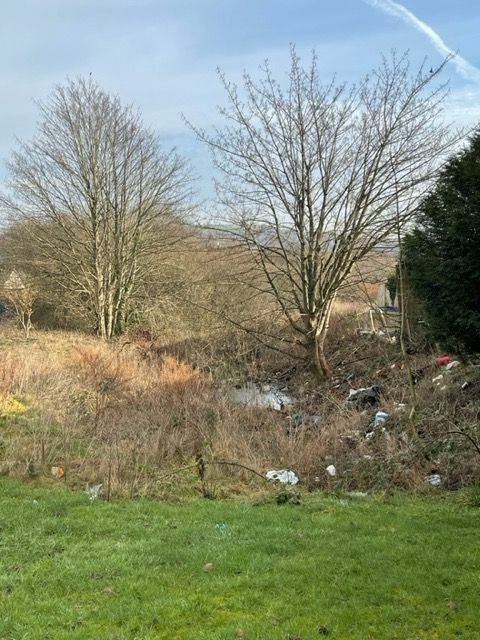
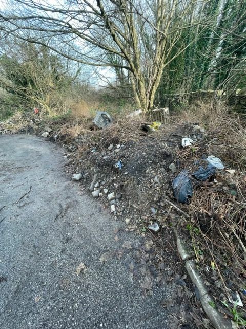
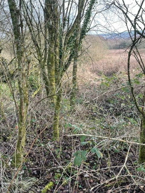
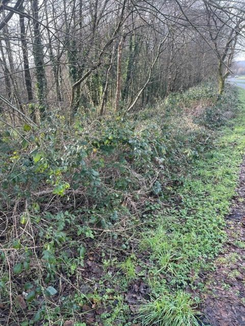
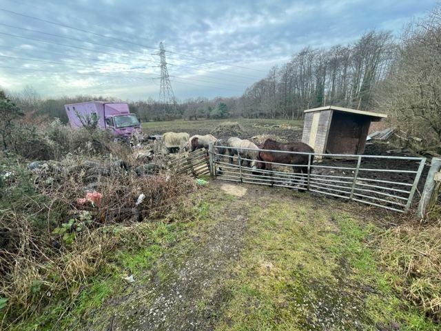
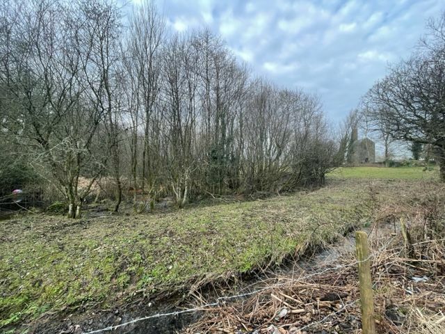
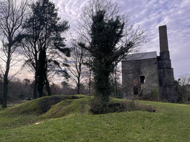
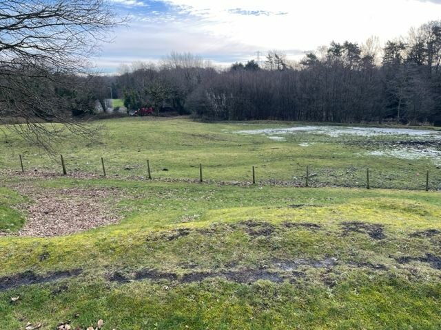
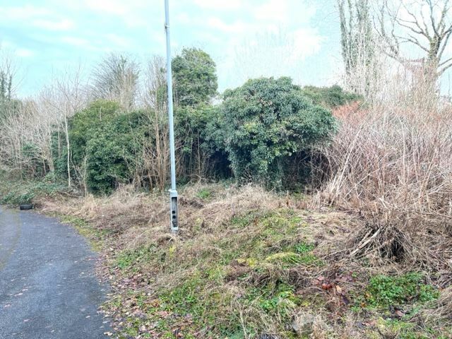
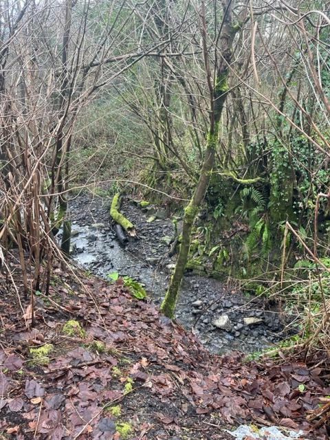
More on Smith's Canal I decided I wanted to know more about this remote canal, so travelled to Swansea last week to see what more could be found. The reality is that even where there should be remnants - because the canal hasn't been built over - it is remarkably difficult to get to the original line of the canal. From Llansamlet church eastwards to the starting point, the canal should be accessible and as it's the absolute middle of winter, there is minimum vegetation. But still it's almost impossible to quickly or easily access the line of the canal. This is the Plough and Harrow pub, and looking east. The canal ran towards me along the tarmac (which is now the entrance to the Llansamlet Community Centre). The pub car park is to the left. There is a b&w photo of this scene and is the only photo I have seen of the canal fully in water, although without any boats. This is now looking west from the south side of the community centre. The canal ran alongside the rough grass and the lower brick wall at the end is where the canal continued. Most of the next mile is covered by the Swansea Enterprise Park. On the other side of Church Road in Llansamlet, looking east. I had hoped to walk this stretch towards the start of the canal. But it just wasn't possible. The fly-tipped rubbish is obvious. The land beyond doesn't seem to be used but access is tricky as there are few public footpaths. It's not even clear who owns the land. I'm not overly bothered about trespassing as long as I'm not damaging crops, fences, assets, etc. But physically it wasn't possible. The water can be seen here. This is the route of a public bridleway (not just a footpath!) from the end of Tawe Road (off Peniel Green Road) and it goes north towards the new B4625. Completely impassable and no sign of a path. The wall on the right is the wall of the former Swansea Vale Railway. Long gone. Getting to the canal from the north - the B4625 - is a lot easier although the path is obviously little used. The fly-tipping at the southern end might have something to do with it. The canal line is straight ahead along the line of the young trees, with marsh to the right, and this is heading NE. Ive learnt that on many disused canals, the trees tend to grow out of the former canal bed rather than the bank or the former towpath. The canal crosses the B4625 here but no trace on either side beyond some small ridges. The canal was crossed by the Swansea Vale Railway. However, as the canal was closed in 1852, I'm not even sure if there was a bridge over the canal. This is a field between the old railway embankment and the M4 embankment off to the right. In early 6" OS maps, there is clearly a line of marsh and even 'canal width' open water across this field, with the latter more or less where these ponies are standing. The start of the canal was the Gwernllwynchwyth estate and the pits around it. The most likely end point (ignoring what Coflein record as they are clearly wrong) was Scott's Pit, seen here. The old engine house remains and can be seen on a rise in the middle right of the photo. The canal almost definitely ended in this copse in the field. It is possible that the canal continued just beyond the barbed wire at the lower edge of the photo. However, this seems to be on a slight rise whereas the copse is flat. This is the road and parking opposite the Scott's Pit site (to the right). However, this odd road shape shape has been here since the earliest OS maps and must surely have something to do with the canal and/or local waggonways. The engine house at Scott's Pit. There has been little excavations done to date. The field to the immediate south of Scott's Pit with the copse beyond the frost on the far side of the field. The photo of the copse above was taken from the gap in the trees on the upper left. An additional twist to this story is the Gwernllwynchwyth (try saying that to a taxi driver after a few pints) which is now completely ruined and overgrown with absolutely no attempt to even make it safe let alone any form of interpretation. The estate was the focal point of the coal estate, with pits scattered around. Smith's Canal (Smith bought the estate early on) was replaced and it is likely that the upper 0.75km was closed early on and a waggonway ran from the pits around Gwernllwynchwyth for about 500m to a 'new' terminal basin. As a final treat (I will do an update on the Hafod-Morfa end of the canal in due course) this is part of an artificial water supply system known as Chauncey's Great Leat that supplied water from streams in the Gwernllwynchwyth estate to coal mines and early industry in Pentrechwyth several miles to the southwest, close to the Tawe. This arrangement doesn't make total sense because one immediately asks the question why not get water from the Nant y Fendrod or even the Tawe itself. Bricks and stone linings can be seen in the watercourse, but - as everywhere with this long-lost canal - it's so difficult to access. There is no connection possible between Smith's Canal and the Swansea Canal. The former is on the eastern side of the Tawe, the latter alongside-ish on the western side.
 2 points
 -
2 points
-
You've just got to be careful that the wire brush isn't polishing rather than keying. Clive has a massive angle grinder with a huge sanding disc that he might lend you if you ask nicely. If you're gentle you could give the steel a key without removing good steel. Or just do the same with a mini angle grinder as you'll probably have more control. A coarse flap wheel disc will do it but you'll have to be gentle. You don't want to remove good steel.2 points
-
This post cannot be displayed because it is in a forum which requires at least 10 posts to view.
-
This post cannot be displayed because it is in a forum which requires at least 10 posts to view.
-
This post cannot be displayed because it is in a forum which requires at least 10 posts to view.
-
This post cannot be displayed because it is in a forum which requires at least 10 posts to view.
-
This post cannot be displayed because it is in a forum which requires at least 10 posts to view.
-
This post cannot be displayed because it is in a forum which requires at least 10 posts to view.
-
This post cannot be displayed because it is in a forum which requires at least 10 posts to view.
-
This post cannot be displayed because it is in a forum which requires at least 10 posts to view.
-
Excellent news, thanks for the update! I think we can safely blame the sausages.2 points
-
I solved the problem, folks. My incompetence knows no bounds: I forgot I set the fridge's temperature dial (it was hidden behind some sausages) to 0. I just turned it now and the fridge came back to life. Gonna go cook those sausages now...2 points
-
This post cannot be displayed because it is in a forum which requires at least 10 posts to view.
-
This post cannot be displayed because it is in a forum which requires at least 10 posts to view.
-
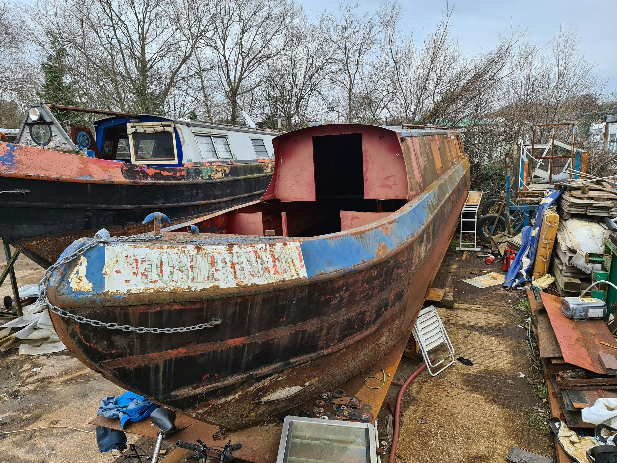
Been down to the boat today for the first time this year, pleased to report that all is well. Did a bit more welding and measured up a few bits for the next steps. Thought I'd get some photos of her as she sits now, quite striking proportions! There's a few bits of life that are happening in the background that are a bit drastic but should really benefit the progression of this as a project, it's probably going to be moved to a more convenient yard fairly shortly
2 points
-
Honda 5 is an ok outboard. 4 stroke. I've got a Yamaha Malta 3hp 2 stroke as well as a Mariner 4hp 2 stroke. Nice units but a bit annoying being two stroke. These came with boats I bought. Also have various electric outboards of course. About 6 of them. Possibly too many outboards ? There are people who say, possibly correctly, that the Yamaha Malta was one of if not the best small outboard ever made. I also have one of the old partly water cooled Honda 2 outboards (1995) which is really good but a bit small for a 13 footer. You could do worse than a Yamaha Malta. 3hp is an interesting size for an outboard. On balance I would look for a Honda 5 but do research about their problems. There is something going on with the exhaust manifold on these. Searches on Google including the word forum yield interesting results. I would steer clear of the motors which look like a strimmer as I am convinced they are for landfill. Some people advocate the older 2 cylinder evinrude and Johnson outboards. There is a member on here called @Murflynn who had a little evinrude 4hp twin as a backup for his boat on the Thames. I've not run one of these but being a twin they are interesting as slightly quieter and probably a bit more torque.1 point
-
I reckon Rusty's palm callouses would be up to the job ...1 point
-
The benefit of opt 2 (as I see it) is that it's going to be better than bitumen for the 2(ish) years with regard to diesel spills. 2ish years is also when you should be checking your prop, anodes & hull anyway, it's not like you can say, 'right, that's it for 10 years...' and not bother hauling out. Cons - expensive innit. Seriously though, I'm well impressed with Vinyguard, which definitely IS meant to be used over bitumen.1 point
-
No there is a free travel area between the UK and Ireland that predates the EU. So we can come and go as we please.1 point
-
This post cannot be displayed because it is in a forum which requires at least 10 posts to view.
-
My info could be out of date, but I read somewhere that the Common Travel Agreement between UK and Ireland allows free movement, and also access to medically necessary healthcare with the same rights as a native. Pardon my brief but necessary diversion into politics here- it is my opinion that the NHS in England has been deliberately run down over the last 12 years, and that it will be very difficult for a future Labour government to reverse the damage- so I have a very pessimistic view of the quality of healthcare provision that will be available to working class people in this country over the next 10 years or so. One of the benefits of residing for 5 years in Ireland, providing you can prove residence) is that you might be able to apply for an Irish passport, and thereby obtain the excellent standard of healthcare that is available in countries like Germany. For a man approaching 60 and not in the best of condition, the prospect of obtaining what I believe to be a far superior standard of healthcare than I could ever get in the UK has a significant appeal. It could end up being the sort of thing that adds a number of years to one's life. At the moment this country is struggling to even get critically ill people transported to hospital, and with 7 million people on waiting lists, even routine elective surgeries might be two years away. For balance, I should add that other opinions about the state of our NHS and its future are available. So to be honest, a move to Ireland would not just be about the lovely scenery and the wonderful people, I am also being a bit selfish in a way.1 point
-
Looking good! This is my favourite thread on this forum - please keep the updates coming…1 point
-
This post cannot be displayed because it is in a forum which requires at least 10 posts to view.
-
Clive's hydroblaster will take off all the existing bitumen. It's just very high pressure water - there's no ability to add sand or grit. He struggled to get all my 7 year old epoxy off with the hydroblaster so he switched to grit blasting but for getting off bitumen it will be fine. Some may have had success painting epoxy over bitumen but it's not recommended practice. No epoxy manufacturer or paint supplier I know of recommend doing that in their application guides. After the hydroblasting I'd try to give the whole hull a key before applying epoxy if you can. The problem with Blackthorn is that it's very weather dependent as you're not under cover.1 point
-
It is amazing how satisfying a big splash can be. I would suggest people throwing them in water are subjected to the same procedure by random passers by and this to be subject to community awards and YouTube clips. That'll show 'em. What I do is take the trolley back to the store, get my £1 back and throw it in the canal. Real rebel me.1 point
-
This post cannot be displayed because it is in a forum which requires at least 10 posts to view.
-
Thanks. Epifanes?1 point
-
This post cannot be displayed because it is in a forum which requires at least 10 posts to view.
-
Probably formed impenetrable walls1 point
-
This post cannot be displayed because it is in a forum which requires at least 10 posts to view.
-
This post cannot be displayed because it is in a forum which requires at least 10 posts to view.
-
We had a chap Offshore, we nicknamed him "Roger Rat" for his radio procedures1 point
-
21 minutes ago, klgilfillan said: Hi all, I've been told by my boat safety inspector that I need to replace the plastic drain plug on my fuel filter with a metal one. The filter is a Lister 751-18100 and the thread of the plastic plug seems to be about 7.5mm. The smallest metal replacement plug I can find is 9mm. I have looked up a replacement filter that comes with a metal plug (e.g. Delphi) but the spin-on thread is 1.3mm smaller than the Lister filter spin-on thread. Has anyone else had difficulties solving the metal fuel filter drain plug problem? Any suggestions? Think you will find an M8 bolt will fit. Pretty sure thats what I used. You just need a short one. I just cut one I had down. A rubber washer comes with the filter I think. I have two one on the filter in use and another on a spare filter. Makes it easy at filter change time.1 point
-
Tesla seem to be moving to LFP for standard range but keeping NMC for long range vehicles. https://www.notateslaapp.com/news/563/tesla-s-lfp-iron-batteries-compared Also interesting about the LFP was that there were mass failures of Valence battery packs in the "Boris Bus" which was the modern rounded shape hybrid bus built by Wrightbus for Transport For London. https://www.bestmag.co.uk/londons-hybrid-buses-suffer-li-ion-battery-failures/ "31 Jul 2015 Out of the 500 new Routemasters currently on the roads, 80 of them are running in diesel-only mode because of failed batteries, and 200 of the buses are due to have their batteries replaced, TfL told the BBC. The first new Routemasters were introduced in February 2012, with problems with the batteries being flagged up as early as March 2015." Intriguing story as that must have been a big hit for the manufacturer. Don't know where all the Valence batteries went or what was wrong with them ... however driving a bus on electric power is seriously demanding so maybe they just weren't "hard enough". Anyway LTO looks interesting for hybrid use but it is generally a lot more costly than the LFP. I don't know which batteries went into the problem buses. Its an interesting thing all these Lithium batteries. Chinese electric buses seem to be mostly using LTO chemistry. Very high charge and discharge capability and massive number of cycles some claims say 20,000 cycles. Also not negatively affected by low temperatures. I think the ideal electric boat setup would be a pod drive in the rudder and keep the existing diesel engine. I suppose this might make steering awkward but if the control for the motor was fixed to the end of the tiller arm as a twist grip you could just take the power off when needing to apply rudder. People would have to learn new steering techniques but it could be quite rewarding in a way. Plus that way you would have redundancy as there would be two propulsion systems. Large alternator driven by the tailshaft from the main diesel engine for charging the C10Kwh battery bank. Just size the batteries to run for a couple of hours at max power (4kw pod would do it). Cover roof of boat in solar for extra input.1 point
-
Thanks Paul just read your edit - I have owned Cobo for just over 5 years Thanks too John V I've been told the worst bits are around the pool of London. I like the idea of stopping at Southend !! PS yes she has quite large (4.5 sq inches) scuppers in well deck but i would be cutting a piece of 18mm ply to board over that area as well for safety.1 point


This leaderboard is set to London/GMT+01:00