Richard West
-
Posts
100 -
Joined
-
Last visited
Content Type
Profiles
Forums
Events
Gallery
Blogs
Store
Everything posted by Richard West
-
I reckon it's Great Barr Street Bridge since someone has kindly pencilled in "Heath Mill Lane". I assume the warehouse was demolished to make way for the railway bridge. Map Link
-
Have you used the "Problem with Order" button on the order details page?
-
Operated by RVL aviation, one of their specialties is mapping "RVL provides the aviation expertise for the UK’s leading exponents of aerial photography and mapping." https://rvl-group.com/
-
This post cannot be displayed because it is in a forum which requires at least 10 posts to view.
-
This might help. https://maps.nls.uk/geo/explore/side-by-side/#zoom=17&lat=52.5295&lon=-2.0178&layers=175&right=osm
-
This post cannot be displayed because it is in a forum which requires at least 10 posts to view.
-
This post cannot be displayed because it is in a forum which requires at least 10 posts to view.
-
Google Earth Canal & River Map. (Canalmaponline)
Richard West replied to Chris Lowe's topic in History & Heritage
This link might be of some use. Link -
Some brilliant detective work there! The site can be seen on some aerial photos on Britain from Above. https://britainfromabove.org.uk/en/image/EPW024942 https://britainfromabove.org.uk/en/image/EPW011890 https://britainfromabove.org.uk/en/image/EPW046833 You have to log in to be able to zoom in.
-
It's on 4/7 01.10 AM Wednesday but their schedule classes it as Tuesday.
-
Thanks for the heads up. Being repeated on Wed so have set to record series.
-
I don't think it will. I've had viruses on a Windows virtual machine running under Linux.
-
This post cannot be displayed because it is in a forum which requires at least 10 posts to view.
-
Does anyone know this ice breaker location
Richard West replied to canalboat's topic in General Boating
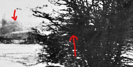
I think that I can see a bridge hole through the bush which could be Apple Pie Lane Bridge and a building to the left which could be Hartshill Wharf. The line of trees seems to stop at the bridge which would fit with the present view although the house on the bridge would have to be later than the photo.
-
You are welcome to use any info thgat's useful to you from my map. See sig.
-
He has done. Did you not click "See more"?
-
canalrivertrust.org.uk is fine here but watersidemoorings.com seems to be offline.
-
How about Ophelia Balls?
-
Ah but the first line says
-
This one at Wool Road? https://www.google.co.uk/maps/place/Huddersfield+Canal+Society/@53.5560448,-2.008168,3a,15y,20.81h,87.52t/data=!3m6!1e1!3m4!1sLs2ytdV0StE4qR0U6zPv6Q!2e0!7i13312!8i6656!4m13!1m7!3m6!1s0x487bb5e75d79b08b:0x70e8e3112c95b659!2sDukinfield!3b1!8m2!3d53.478764!4d-2.094523!3m4!1s0x0:0x375b97ee8f4c7ada!8m2!3d53.5561556!4d-2.0079017!6m1!1e1 Nearer the tunnel.
-
I haven't set anything up on the new forum. I just log in, click the "Unread Content" at the top, then click the blue dot against a thread I am interested in and I'm taken to the first post that I haven't read. (Actually, I middle click to open it in a new tab then scroll down to the next interesting topic and repeat...) Once I have seen all I want to, I click "Mark site read ".
-
CWF Broken - Error With The Database
Richard West replied to Alan de Enfield's topic in Technical & Account Support
Looks like the spillchock version of "New Content" button. -
I found this page, https://canalrivertrust.org.uk/news-and-views/blogs/boating-team/mapping-boating-facilities-and-winding-holes which links to this document https://canalrivertrust.org.uk/media/original/30246-winding-holes-surveyed-as-at-12-oct-2016.pdf
-
Genuine question on staying on visitor moorings in winter
Richard West replied to Dave_P's topic in General Boating
According to this map it is a service mooring. -
How much artistic licence? (Just a bit of fun)
Richard West replied to Chertsey's topic in History & Heritage
Looks like here https://www.google.co.uk/maps/@52.5995077,-2.1256432,166m/data=!3m1!1e3?hl=en