Scholar Gypsy
-
Posts
4,953 -
Joined
-
Last visited
-
Days Won
2
Content Type
Profiles
Forums
Events
Gallery
Blogs
Store
Everything posted by Scholar Gypsy
-
My stern tube now drips much less after a week out of the water in September (for blacking). Very strange!
-
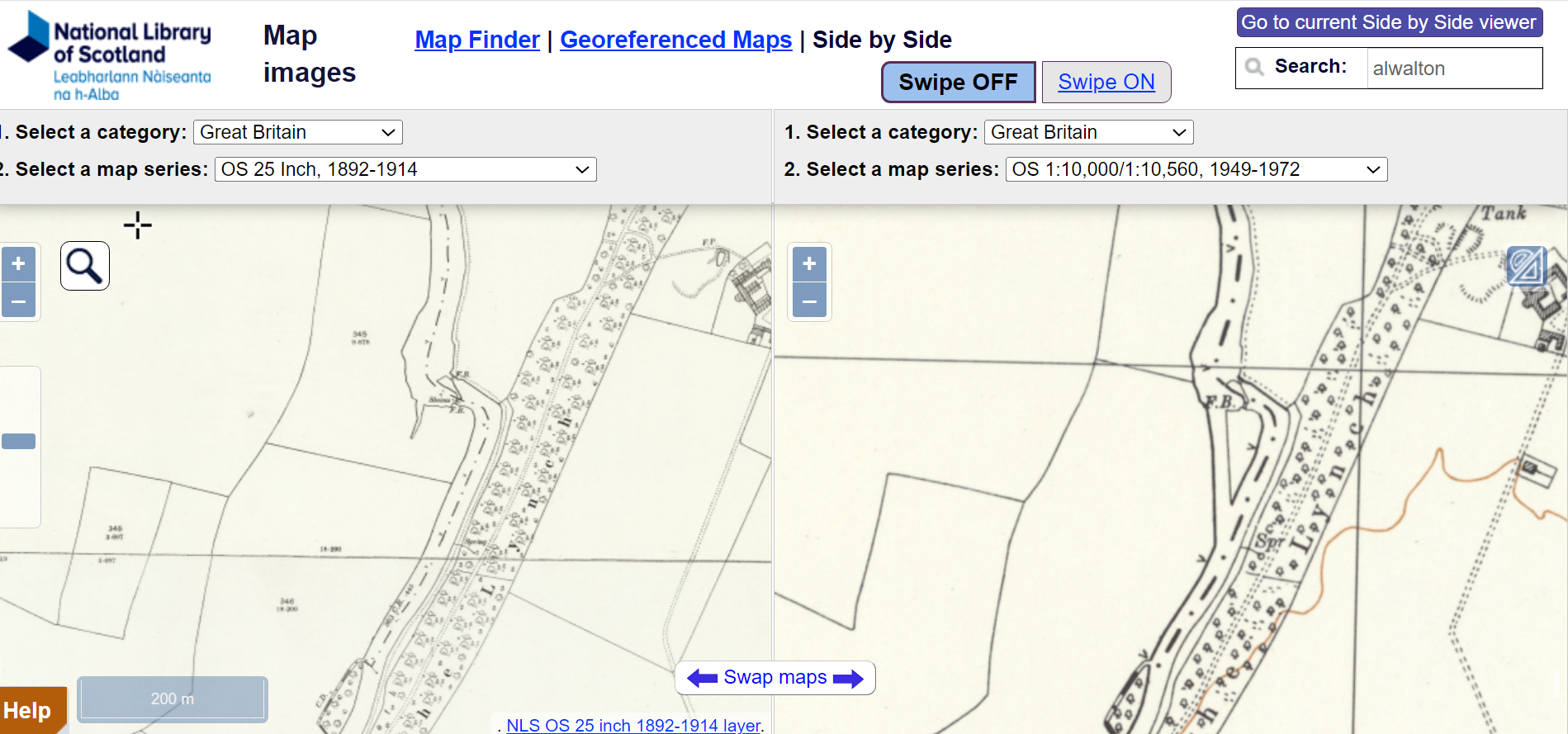
This is the one I had in mind at Alwalton - a new stretch of river was built to take out the kink! https://maps.nls.uk/geo/explore/side-by-side-old/#zoom=15.8&lat=52.55889&lon=-0.32293&layers=168&right=193

-
I think that's a flash lock, ie just one guillotine gate. When a boat wants to transit it is lifted and the boat either zooms downstream or is winched upstream as the levels equalise. I have seen photos of a very similar structure on the Brandon Ouse, near Hockwold. The remains of that are just about visible. I think one can also see the old lock structure downstream of Awalton, though I may be imagining that. One certainly can just below Lower Wellingborough lock (which looks like a 1970 structure rather than a 1930s one).
-
Anglia Water trying to Stop Navigation on the Cam
Scholar Gypsy replied to matty40s's topic in General Boating
Helen is of course, as Chief Executive, representing the views of the Conservators (who employ her). I do think this subject has got somewhat garbled in the press coverage. There is no intention on the part of AW to "stop navigation on the Cam". But (as I said earlier) there is more to do to understand the precise impact (if any) on navigation of the proposed works, during construction and then permanently, and to ensure that the legal powers granted to AW are no more than are necessary. The other point I should add is that there are of course lots of other impacts of the project, for example on water quality and other environmental aspects, but these are primarily a matter for other agencies rather than the Conservancy. -
Anglia Water trying to Stop Navigation on the Cam
Scholar Gypsy replied to matty40s's topic in General Boating
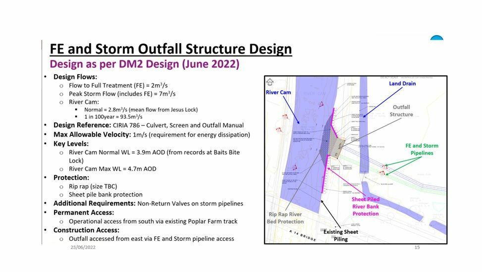
I hope I can offer some reassurance here, as I am a Cam Conservator. We have been discussing this a lot for quite some time (and certainly since I joined in January 2023), to understand the nature of the structure, and the impact on navigation a) during construction and b) when built; and what that means for the powers AW are seeking. We have submitted lots of questions to Anglian Water, and as you can see from this article the Planning Inspector has just held the initial scoping meeting at the start of the process of approving the works. The Environment Agency will of course have a major interest - we are just the navigation authority. Here's a drawing of the proposed outfall - on the opposite side of the river to the existing one which will be removed. It does involve works to protect the bed from scouring, but the bulk of the concrete structure is actually behind the river edge. We are also interested in the rest of the project, which collects sewage from as far down as Waterbeach and pipes it south (upstream) to the new STW. This means that a number of smaller existing works (Waterbeach, Horningsea) can be closed, and a new tunnel built under the river between Bottisham lock and Clayhythe. PS The subject of this thread is somewhat misleading, IMHO. PPS here are some photos of Jesus Lock, currently with no gates ... https://scholargypsy.org.uk/2023/10/26/jesus-lock-cambridge/
-
That's a tougher test. For example if you make a modification to your boat there is no requirement to get a new certificate, but the work still has to be done in a way that maintains scheme compliance.
-
Thanks for the comments. There is (of course) a cover that fits on top of the lot, to avoid shorting. The thin wires connect to a battery charger (not in use now I have solar), and a sulphator. There are a number of fuses just out of shot (eg for the Smartgauge, solar, and bilge pump).
-
CRT licence terms and conditions "The Boat must always comply with Boat Safety Scheme requirements" Section 6: https://canalrivertrust.org.uk/refresh/media/original/43943-general-terms-and-conditions-for-boat-licenses-june-2021-searchable-file.pdf Prompted by my recent full survey, I finally got round to strapping the batteries down. They have never moved an inch in 30 years, despite some quite rough water conditions....
-
I was going to quote my Craftinsure policy but @nicknorman beat me to it. I guess the problem the insurers have is that they have literally no idea how competent a particular skipper is - as we don't need any licence etc. The craftinsure underwriters were sensible when I did a Wash crossing a few years ago, ie a list of extra conditions which suggested to me someone who understood what the risks were on this trip, and what mitigations were sensible and possible. It's worth noting that on some rivers - the Nene is a good example - the whole river goes on red even when the problem is fairly localised (or as with the recent storms, as a precautionary measure before the significant rainfall has actually happened). If you know the river then moving in those conditions is not reckless (I would argue). The EA are working on this, but it's not a straightforward issue.
-
This website provides some practical advice on how to get there from the canal system at Northampton. It includes links to various guides and websites. There's a great list of moorings above, I am moored at Cathedral in Ely. https://goba.org.uk/a-guide-for-visitors-to-the-east/ PS you can also get to the rest of the system by crossing the Wash to Boston and Lincoln.
-
I would say that is fail unsafe, as if there is a problem with that electrical circuit the engine might decide to stop at a most inconvenient moment!
-
Foxton and Watford locks were built as narrow locks. The left hand map here shows there were sideponds in the mid 1800s (and probably earlier). Some of them got a bit squished when the inclined plane was built ca 1900 (see right hand map). The one by the crossing pound in the middle was completely obliterated, I think. https://maps.nls.uk/geo/explore/side-by-side/#zoom=16.3&lat=52.49936&lon=-0.98177&layers=257&right=168
-
With Bingley, if you are going uphill and all the lock chambers are empty, then you will need to take four lockfulls of water from the top pound, to fill up each of the top four locks. Conversely if you are going downhill and the locks are full then you will empty four locks of water into the lower pound. Not as efficient as a Foxton type arrangement. (To make Bingley more efficient, you need something like boats only going uphill in the morning, and only doing downhill in the afternoon. This is a bit counter-intuitive, I know, and ignores the possibility of shuffling.)
-
Comparing Foxton and Bingley - both five lock staircases - the latter will use more water, unless all the boats are travelling in the same direction. (Ignore the fact that the latter are wide locks, which also permits the shuffle maneuver...) I quite like the French approach which is to open all the gates and then fill the chambers up from the top, moving the boats forward as you go!
-
One just above Duke's lock. Banbury, above the lock. Heyford mill is electric, ditto Thrupp. Thats all I can remember from my recent trip...
-
I agree this is a pity. But gives me an opportunity to show my Banbury stick in operation this summer (just north of Wolvercote lock). The bridge is naturally fairly finely balanced, and it was windy, so that's why there is a rope to hold the bridge down on the pole. This bridge also had a locking mechanism (you can see it at ground level) that uses a standard CRT key.
-
Yes, agreed. PS Looking on Google earth, the sideponds at Watford are about 350' x 50', which is over 30 times the area of the lock. The ones at Foxton are more variable, as to shape, size and orientation. This map makes it clear they were squashed up a bit when the inclined plane was built... I think it also shows that the pound between the two flights used to be much bigger than it is today.. https://maps.nls.uk/geo/explore/side-by-side/#zoom=16.3&lat=52.49939&lon=-0.98171&layers=257&right=BingHyb
-
I don't think this calculation is quite right (though the operating process is correct). With side ponds that have the same area as the lock, then 1) With a single side pond the water level will vary between 1/3 and 2/3 full. When going downhill you put 1/3 of a lockful into the side pond (which then goes from 1/3 to 2/3 full), and then you empty the rest into the lower pound. When going uphill you take 1/3 of a lockful out of the sidepond (which then goes from 2/3 to 1/3 full), and then fill the remaining 2/3 from the upper pound. 33% of water saved. 2) With two side ponds, the upper one will vary between 1/2 and 3/4 full, and the lower one between 1/4 and 1/2 full. Going downhill you put 1/4 lockful into the upper pound (which goes from 1/2 to 3/4 full, with the lock going down from full to 3/4 full). Then you put another 1/4 lockful into the lower pond (which goes from 1/4 to 1/2 full). Then you empty the remaining 1/2 lockful to the lower pound. Going uphill you take 1/4 lockful from the lower pond (which goes from 1/2 to 1/4 full) and then another 1/4 from the top one (which goes from 3/4 to 1/2 full), and then fill the remaining 1/2 lock from the upper pound. 50% of water saved. With large side ponds (say 20 times the area of the lock, which I would guess is the case at Foxton and Watford), they are much more efficient as the level in the side ponds can be assumed constant. So a single side pond will be at the 1/2 full level, and can take and then discharge 1/2 a lockful of water with only a small change in level. This is logically equivalent to replacing one deep lock with two shallow ones, and so will use half the amount of water. I really should get out more.
-
It's hard to see how this would be possible, as a) FBW is a coalition of many different organisations, many of which are not charities (eg boat clubs); and b) I don't believe FBW has yet been set up as a separate legal entity, let along a charity. However I think you could make a donation to IWA and ask for this to be used to support the FBW campaign.
-
The maths of side ponds is quite interesting (well I think so!). The key variable is the ratio of the area of the pond to the area of the lock. If this is 1:1 then you get one solution (for the full and empty levels of each side pond, and for the amount of water that is saved - for example with two side ponds you can save 50% of the water, with one only 33%). If the ratio is much bigger then one can assume the level stays fixed in the side pond (like Foxton), and two ponds can save 2/3 of the water. One could re-imagine each five lock flight at Foxton as one huge lock, 70' long and with a single drop of 37'6", with four large side ponds at intermediate levels. In this case 4/5 of the water is saved (the consumption is to fill or empty the last part) compared with operating it as a single 37'6" lock. Of course the reason the lock is not built that way is that it would require rather large bottom gates (*), though it would save on brickwork. (* Footnote, unless one made the bottom end of the lock a solid wall, with a hole for the boat to go through ...)
-
No. The Red paddle connects the side pond to the lower lock, the white paddle to the upper lock. When both paddles are up then the water level equalises between both locks and the side pond, you open the gate and move from one lock to the next.
-
Historic England Blog Post, The Thames From Above
Scholar Gypsy replied to Chris Lowe's topic in History & Heritage
Thank you - some nice photos. That almost looks like the Waverley at Southend pier.... but the wrong number of chimneys https://scholargypsy.org.uk/2022/09/29/ps-waverley-gravesend-to-clacton/ -
A very fair description! I do a lot of cruising on the Fens and Middle Level as well, and it has been three years since I have had to go down the weed hatch. (though my son had to go down recently to untangle the stern line ....)
-
Ah, I was wondering if I couldn't see this data as I have a gold licence and my home mooring is on an EA waterway. But I see that's not the case as the option has been withdrawn.
-
I suspect another reason for this byelaw is to stop boats using their engine to control their position in the lock. That's what the bow and stern line are for.