Scholar Gypsy
-
Posts
5,054 -
Joined
-
Last visited
-
Days Won
2
Content Type
Profiles
Forums
Events
Gallery
Blogs
Store
Everything posted by Scholar Gypsy
-
Yes, you are right. Even at weekends it was normally closed.
-
That could have been us on that 1970s video, though sadly it isn't. I remember spending quite a bit of time wandering around the sidings looking for someone to open the bridge for us....
-
Same for me. I have a fixed TMV near the calorifier that mixes and hot and cold, is the right temperature for the washbasin and the shower, and keeps a stable temperature whatever is done elsewhere. The galley sink is connected direct to the hot, good for filling kettles and doing the washing up.
-
Scholar Gypsy/Simon Judge of this parish on YouTube..
Scholar Gypsy replied to a topic in General Boating
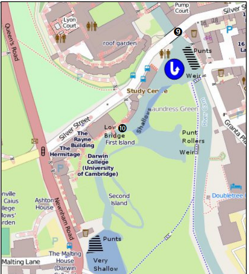
Porter is the correct term. The works are until June 2023, although the river (ie the centre arch) is only closed to powered boats for the month of February. More detail just published here: https://www.camconservancy.org/public-announcement In most parts of the river the depth is normally 3 feet, I would say. I reckon we are about 24 inches at the stern. The shoal that was causing the problem is marked on this chart (from the excellent guide by @FadeToScarlet) just to the right of bridge 10. It gives access to a wide and deep pool (with piling on the south shore) just before the weir and punt rollers, which is a very easy place to turn. I think I could probably have battled my way over the shoal, but it didn't seem a very good idea. So we backed down to the marked turning point (at which point one of the competing punt firms said "Oi mate, you can't park there"). It was fine the following day when the water was back to normal (ie 9" higher). There are half a dozen residential moorings on the right bank above the lock, they use the lock all year round to access the water point and the pumpout (when it is working...). Maybe they used to be visitor moorings too?
-
Scholar Gypsy/Simon Judge of this parish on YouTube..
Scholar Gypsy replied to a topic in General Boating
It's available now! -
Scholar Gypsy/Simon Judge of this parish on YouTube..
Scholar Gypsy replied to a topic in General Boating
I do take guests on these trips, as you can see. If anyone is interested please send me a DM. Will probably be autumn 2023, as there are works on Trinity Bridge at the moment. (We didn't hit it). -
Scholar Gypsy/Simon Judge of this parish on YouTube..
Scholar Gypsy replied to a topic in General Boating
Here is the sequel ... -
Scholar Gypsy/Simon Judge of this parish on YouTube..
Scholar Gypsy replied to a topic in General Boating
Thanks! Part 2 should be out fairly soon. Tim has a speaking part in that, as well as some physical action ... -
My Mitsubishi is self bleeding, ie I just need to bleed at the top of the main filter, which is after the lift pump and on the banjo joint at the inlet to the high pressure pump. I never need to touch the pipes (four in my case) from the high pressure pump to the injectors.
-
Electrification of CRT Broad and Wide Locks.
Scholar Gypsy replied to oboat's topic in General Boating
And don't forget locks where the chamber is 14' or more wide, but the entrance to the lock is less than 14'. As noted above, some on the Great Ouse, and also at Jesus Green lock in Cambridge. -
Scholar Gypsy/Simon Judge of this parish on YouTube..
Scholar Gypsy replied to a topic in General Boating
Sadly the footage of Tim eating his bacon buttie (including black pudding, by his special request) seems to have ended up on the cutting room floor... -
URGENT! Oxford Canal closure at Cropredy NOW?
Scholar Gypsy replied to bpboat's topic in General Boating
Surely the map is incorrect - it doesn't seem to match the words for where you can turn? -
The disco noise from the existing boats can be quite loud on occasion.
-
We were moored in the marina then. I hope you didn't bump into us .,..
-
I agree, that's why I do it once a year (at most!).
-
* Wash the side of the boat with cold water to remove dirt, mud, bird poo etc (you can see my yellow hose, which makes this a lot easier) * Warm water and Autoglym shampoo, with a sponge * rinse again using hose * dry using Chamois leather * Apply resin polish using special applicator (a sort of open glove that your fingers slot into) * Apply elbow grease to get a good polish. (No buffer used). * Apply wax (spray) * more elbow grease to get it really shiny I do about 6 feet at a time for each step of the process. The paint job was done in 2014, so is lasting pretty well. Shampoo and resin polish are on here: https://www.autoglym.com/best-sellers . I think this is the wax: https://www.autoglym.com/products/bodywork/wax/rapid-aqua-wax-complete-kit
-
I use Autoglym, in theory once a year but in practice rather less often. I finally got round this week to doing a wash, shampoo and polish on the right hand cabin side. This photo shows the before and after. I might do the wax if I am feeling really keen.
-
The master copy of your emails should be sitting on a google server somewhere. Log on to https://mail.google.com/mail/ using any web browser. Put in your email address and password. The app on your Ipad (and indeed many other devices) should synchronise with this. You can access other Google functionality by clicking on this icon. For example I set my phone to save all the contact details (phone numbers mainly) on Google. This gives an automatic backup, for example if I were to drop my phone in the cut,
-
I know a few boaters who have installed a motorcycle handlebar heater on their tiller, quite effective... For example (US website) https://ripsandrides.com/best-heated-motorcycle-grips/
-
Paddlewheel narrowboat - Unusual, but not unique
Scholar Gypsy replied to mykaskin's topic in General Boating
And here is a photo of the electromagnetic mooring system on the new ferries .... -
Paddlewheel narrowboat - Unusual, but not unique
Scholar Gypsy replied to mykaskin's topic in General Boating
We had a similar issue when everyone queued to get off the boat at Tower Pier - obviously tied up, so sadly we didn't get this announcement from the skipper. There was a bit less interest in the SS Montgomery ... -
Paddlewheel narrowboat - Unusual, but not unique
Scholar Gypsy replied to mykaskin's topic in General Boating
The Waverley was a very smooth ride - almost no vibration or noise apart from swish-swish, even at full speed. -
Paddlewheel narrowboat - Unusual, but not unique
Scholar Gypsy replied to mykaskin's topic in General Boating
Yes, I've not yet managed to get in to look around the church. It's very close to the pier. -
Paddlewheel narrowboat - Unusual, but not unique
Scholar Gypsy replied to mykaskin's topic in General Boating
And I can't resist a few photos of PS Waverley, the last sea-going paddle steamer in the world. A number of us took a trip from Harwich to Tower Pier last week. Here we are moored at Gravesend. https://scholargypsy.org.uk/2022/10/08/waverley-paddle-steamer-harwich-to-tower-pier/- 78 replies
-
- 1
-

-
- Paddlewheel
- Narrowboat
- (and 2 more)
-
@Tony Brooks advice above is spot on. The only other thing I would add is that there are a couple of bridges on blind bends (131 is one that springs to mind). Just slow down well in advance and be ready for someone coming the other way. You could sound your horn, but that does not obviate the need to slow down - another boater may not hear you or may not respond appropriately. Ask yourself "If a boat appeared around the corner now, could I stop or take other avoiding action in time?". If the answer is "no" then you are either going too fast or your positioning is a bit wonky.