StephenA
-
Posts
1,878 -
Joined
Content Type
Profiles
Forums
Events
Gallery
Blogs
Store
Everything posted by StephenA
-

Should I repack the stern gland of a newly purchased secondhand boat?
StephenA replied to Gybe Ho's topic in New to Boating?
We've removed and repacked with the boat in the water. You pre-cut your packing to the right length. Remove the old squished packing and put the new stuff in and re-seat the packing bush, making sure you tighten up the two bolts evenly. Yes some water will come in - but that's what you have a bilge pump for, and if the amount coming in round the shaft whilst you have the packing out is enough to get anywhere near to overwhelming the pump then you've got a serious problem. As for packing - we've picked up a small length and as when we've needed it. Most chandleries sell it - but as has been pointed out there are different sizes so you need to make sure you get the right one. -
We were there about 3:30pm - beer was good and quite a good number of people sitting round outside soaking up the sun.
-
Nick might know - it might be from a specific source or it could just be caused by internal calculations when things have been added and moved round. I've adjusted it but I had to guess at what the actual distance is.
-
If you could provide a diagram showing what is where that would be helpful and we could look at tweaking things in canalplan
-
Are you censoring the word or is it like that on the notice. If you're the censor then I'd be onto CRT about it.
-
Which is why we use the emails as the starting point.
-
You'd have to ask Nick. I have a feeling that similar discussions have taken place in past
-
No problems with co-ordinates as I use geospatial logic (using POINT storage in the DB and ST_Length and ST_GeomFromText in the code) to return the nearest canalplan location to the co-ordinates from CRT. So after that we're just using Canalplan IDs If you click on Plan Round it will find a route that does not include the stoppage. So for my test : Middlewich big lock to Wigan Pier First attempt - bridgewater stoppage. Click Plan around Second attempt - two on Macc, Click Plan around Third attempt via trent and Huddersfield which has stoppages. Plan around Fourth attempt via L&L - success. Those last two I'm ignoring the issue at Vazon bridge as that would kill it dead I'm quite sure we could make it so it did all of that automatically (due to how canalplan generates its routes for you) and basically because I've got the MSC as an excluded waterway it would stop and say it's not possible. But as Canalplan isn't Tom-Tom we don't
-
We would have got those names from other data sets (possibly Edwards)
-
Correct - it simply says your route is impacted and do you want to plan round it and you can then choose to do so. Nothing to do with 365 network maps. Canalplan knows the start and end dates of closures and the locations. If you plan a route that goes through those locations with dates in the start to end date range it flags it up. CP tells you that your route is impacted and offers you the choice to plan around it. This is because I might be planning a route with no specific dates set and if I plan it today canalplan will point out the currently active closures. but I might not actually care.
-
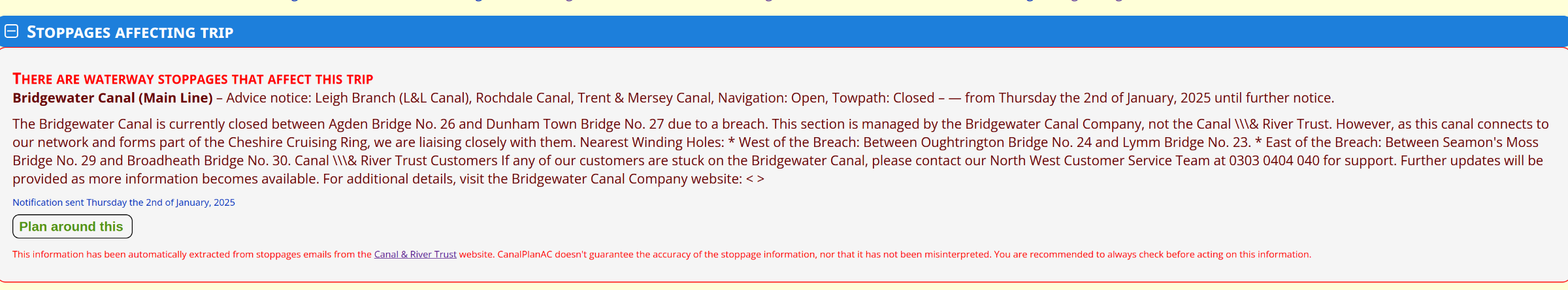
Yes they did - luckily I already had code to check for stoppage updates on their website so I just repurposed a pile of the code to handle the closure emails. The stoppage was there but 1) It's a tree down. If we put every tree down stoppage in canalplan then planning anything would swamp people with notices that their chosen route was impossible 2) It came in on Friday morning when I was at work. There is a manual step in stoppage processing which is to check that it's actually right, which it often wasn't due to the way CRT sent stoppages - the new format is a lot better in getting things like places right. After work I went boating and didn't get back until late Sunday afternoon. Planned a route from Middlewich to Wigan Pier. At the bottom is The canal open is because that is how CRT sent it out - the CRT stoppages have a status for canal and towpath. They sent it out as open but we flagged it as a stoppage and canalplan uses that designation (and not the CRT navigation status) to determine if it needs to display a message Trust me it doesn't : Emails arrive. Background process takes the email and gets the CRT URL Background process parses the JSON data buried in the CRT webpage to get all the details and the start end locations (as co-ordinates). Background process then either inserts a new record for a new message or updates an existing one with the new details After work a poor bugger who has spent all day working on commercial databases sits down and checks each "closure" and "approves" the ones that are relevant. Tree downs are not usually put in because there are too many of them and they'd make planning a complete pain. CRT actually published the bridgewater closure so it's in there. https://canalrivertrust.org.uk/notices/01968ad7-992f-7513-9460-52ca6d9dde2f

-
What do CRT say on their stoppages list? Not that there is a Peartree Lane bridge on the Staffs & Worcs
-
In Cheltenham they sit in the trees and pull the acorns and conkers off and throw them at you. Squirrels that is, not rats...
-
I brain cramped - I meant either fully through the DHWT and back to the boiler or round the rads and back to the boiler.
-
' Or do you just pump the whole lot through the 22mm line in the calorifier on the way to the rads like you do in a Domestic set up.
-
But isn't the calorifier supposed to be 22mm as well? If the argument is that the 22mm pipe is needed to ensure the heater can pump the water round properly then......
-
So silly question - if you have 15mm Ts to the radiators (i assume connecting across the 22mm Feed and Return) what's to stop the hot water taking the path of least resistance and going straight along the 22mm pipe and not through the radiator?
-
Because Canalplan was never designed to be an on-the-move application. One thing we are looking at adding is tracking your current progress on a planned route. But for various reasons development on Canalplan has largely been on hiatus for the past year and a bit.
-
I programmed the equivalent of a satnav for canal boats
StephenA replied to Michael Donning's topic in Holidays Afloat
Post deleted by me -
There are bridges in Maine which specifically warn that the bridge deck will freeze before the rest of the road
-
Chesapeake and Ohio Canal - It runs for 184.51 miles through 75 locks from Guard Lock No 8 (which is a dead end) to Rock Creek (where it joins the Potomac River). https://canalplan.org.uk/waterway/h1jf It was supposed to be 341 Miles 676 Yards long with 398 locks with an Ascent & Descent of 3158 Feet
-
I see a lot of posts about how charging LiFePO can burn out the alternator as it will take the max output of the alternator for as long as it needs it and they're not designed for that sort of load. Which is fine - but what is the sensible long term max load you can put on say a Lucas 70A alternator without it burning out?
-
So very planned if they did that. There are some very odd people in Wigan
-
Very. I guess they knocked the pins out and then moved the gate. The notice suggests that the gates at the other end of the lock were open - I'm surprised that a gate with the water behind it would fall out of place. Pagefield is not a deep lock but I seem to remember its top cill not showing and there being a lot of bottom gate below the water line.
-
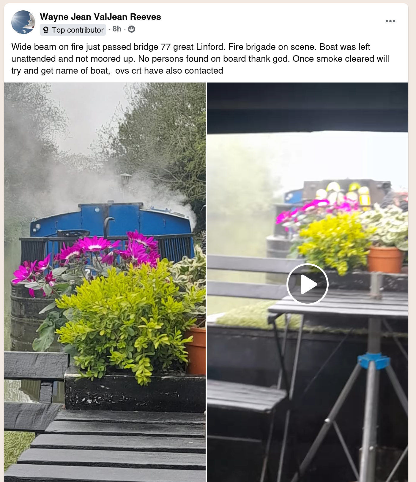
There is a post on FB that suggests it's been torched :