Heartland
-
Posts
3,397 -
Joined
-
Last visited
Content Type
Profiles
Forums
Events
Gallery
Blogs
Store
Everything posted by Heartland
-
I believe that dreaming was not the point of all these suggestions. There were genuine reasons for the proposals and those that invested in such schemes had the hope of adoption. Yet all working canals today came about through those willing to risk capital for the canal to be built. The IWA report of 1965 mentions that canals came about in a haphazard process. I do not agree with that statement as finance for schemes was often dictated by the demands of industry and commerce. Canals reduced transport costs as did tramroads and railways. All originally had limited horizons. With Canals those horizons expanded with the linking up to form a network of navigations. For railways they might have remained small operations, but mergers and the Railway Clearing House helped create that network.
-
There are times when those who suggested canal improvement may have made a significant improvement to the UK canal and river network, yet through a variety of factors have failed to materialise. Perhaps the most ambitious was the MacFarlane report of 1965 for the IWA. In 1963 the IWA looked for an improved waterway network for the remainder of the 20th century and extending into the 21st Century, suggested in 2 phases one conclusion was the revival of a canal across England at the 300ft contour. Despite the engineering challenges, such as scheme may well have improved traffic by boat and reduced the amount of heavy goods by road. But then canal and river improvement had been on going since 1906. What was accomplished was far less and only the Trent, Grand Union, Aire & Calder and Sheffield & South Yorkshire has seen improvements for trade. The Leisure Trade has encouraged canal restoration with new lengths made to enable continued navigation, but what chance is there for the future. A flagship plan to build a canal link from the Ouse to the Milton Keynes has been hampered by a new road project. If built will this waterway be of use for just the boaters, or will there be a trade aspect as well?
-
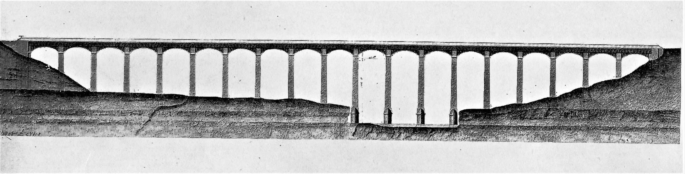
This World Heritage Structure has been looked at in minute detail by canal historians and is appreciated by many. Historic Wales list the correct number of spans as 19, although Wikepedia seems to believe there are 18 arches. Whether the word arch or span is used the number is still 19. There are 18 intermediate supporting pillars and two pillars at either end of the aqueduct. The tallest pillars are the four that have their foundations in the bed of river Dee. The end pier on the Trevor side is the shortest with the base embedded in the hillside. All piers in the Froncysyllte side are of similar height although steadily increasing along the flood plain to the river bank. The first pier and the second pier (the first intermediate pier) are full height and have their base in the bed of the flood plain, the embankment that surrounds both was added during construction as spoil was moved by contractors to make the embankment so that boats could access the aqueduct channel. Attaches is a copy of the engraving from the Atlas in the Life of Thomas Telford, that shows the extent the pillars were constructed.

-
Yes William Jessop was responsible for this aqueduct being there in that form. It predates the Tern Aqueduct (Shewsbury Canal) and perhaps influenced Jessop to recommend iron aqueducts at Chirk and Pontcysyllte.. It would be interesting to see that translation. I wonder if Von Mallard visited the Ellesmere Canal as well? Or did this gentlemen glean his information from other sources ? I also recall a discussion, I had with Ike Argent regarding his various trips on the Derby Canal
-
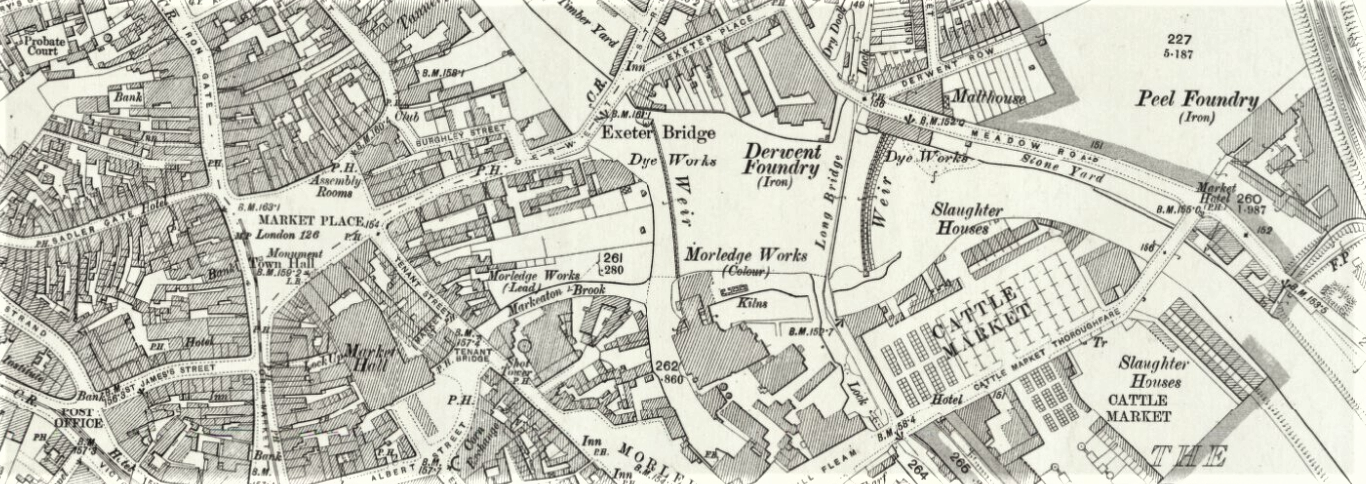
Tumbling Bay is where the Derby Canal route crossed the Derwent. There were locks at both sides of the River. Access to Markeaton Brook was complicated once the canal had been made, This did not prevent access to the Brook, however. There were weirs either side of Tumbling Bay and the weir up stream had a lock (flash lock) where Trent Boats might pass through to reach the wharves at/ near the brook. The canal in order to reach Tumbling Bay from Cockpit Hill canal wharves crossed the mill stream by an iron aqueduct. Attached is a 2nd edition 25 in Ordnance Survey map
-
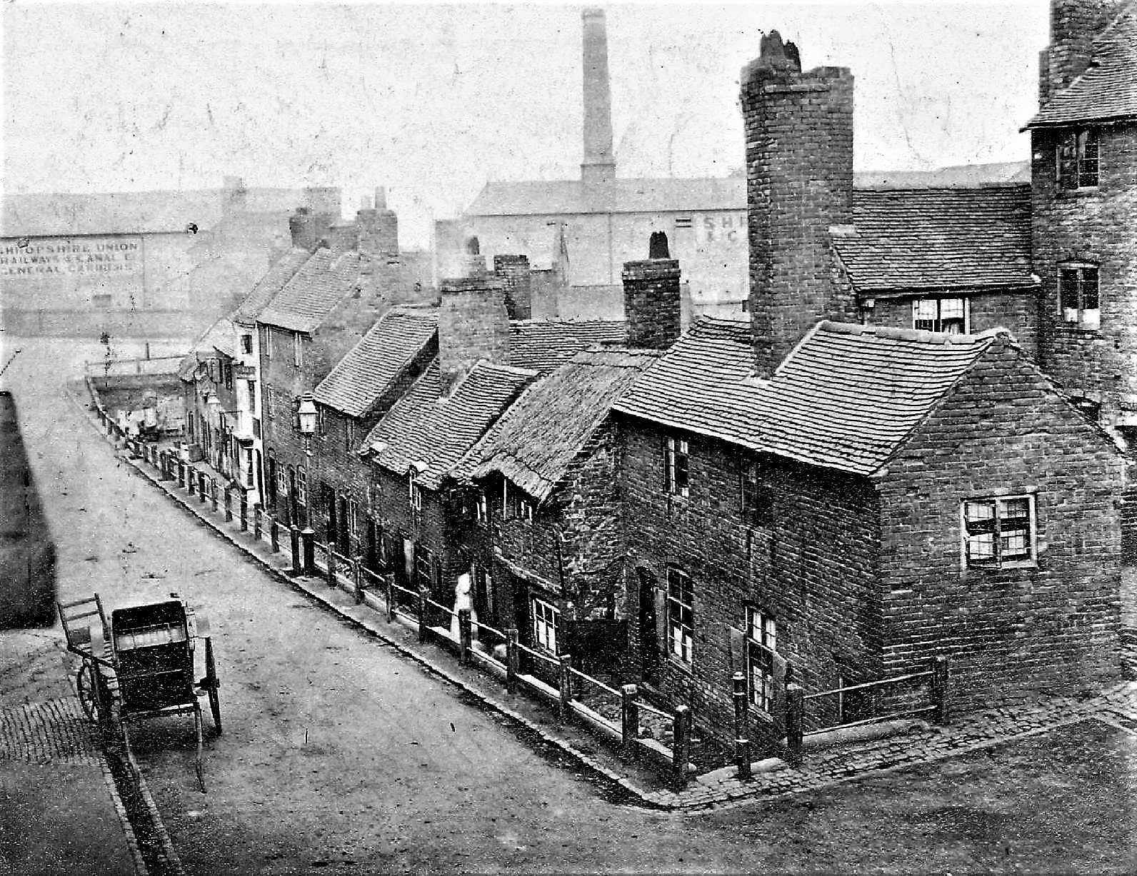
 The view of the old cottages is also of interest. The wording on the walls of the buildings at the end of the street mentions Shropshire Union. To have this view I believe the photograher is looking down the Crescent towards the Shropshire Union Depot that was on both the Gibsons Arm and the Newhall Branch. With regards to the wording Shropshire Union Railways, the plural of the word Railway appears to be reference to the fact that the Shropshire Union in addition to the railway from Shrewsbury to Stafford had the Pontcysyllte Railway !
-
It will be interesting to see how this program details the construction methods and what can seen today. Starting with the Grand Junction bodes ill, as the chronology is not correct. A start with the people Pluto keeps on talking about might have been better....
-
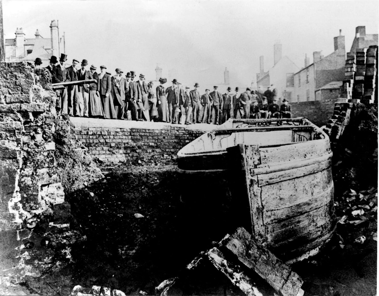
No 12 Is an interesting view of Camp Hill Locks looking up to the top lock The view captioned Gas Street, is not there but at the end of the Newhall Branch- this was a serous breach of 1901
-
The Caerleon Tramroad ran from the Monmouthshire Canal at Cwmbran to the River Usk at Caerleon (4 miles) This line was closed about 1865
-
BCN was definitely a challenge. The way the rain came down on Sunday the roads outside the event were as deep in water as some canals
-
Oh dear, Do locks need to have names ? They can have numbers, but then perhaps not even that. I do not recall any numbers given to the locks on the Foxyards Canal.
-
RHS is this a new form of satellite navigation? Yet the mist must be a problem at times for navigating. The rain on Sunday here in the West Midlands was also not good particularly for the BCNS at Titford
-
Whilst water cans may be one of the best advertisements for canal art, has any body looked at who made them for the boaters and if they were painted? Did the design evolve from a general use, or was it a specific design for boating use. Also the supply of clean water was often obtained from the lock, I believe. Water supply for domestic use, now well established, was not the case in the early days of boating. People often relied on the pump and the well. What changed this state of affairs were the Cholera epidemics and led to the setting up of local boards of Health, on a permanent basis. Water supplies in some cases, that had been private ventures, became the established function of the board of health and their successors the councils. Such changes in the provision of water became more common from the 1860's. Water was required for both domestic and industrial purposes and water companies came to supply both. In the early days, water supplies for domestic use might be rationed to specific hours, to allow for industrial use. It is reasonable to see water cans on boats being a facet more of the period when families lived on them, rather than the early times when a mainly male work force operated the boats. So were water cans the product of a Victorian age?
-
There were market boats that sailed between Bristol, Chepstow, Newport and Caerleon. The quay is shown on the 1881 Ordnance Survey
-
A sad fate indeed, is she now in deep water, or will the wreck be a hazard to shipping?
-
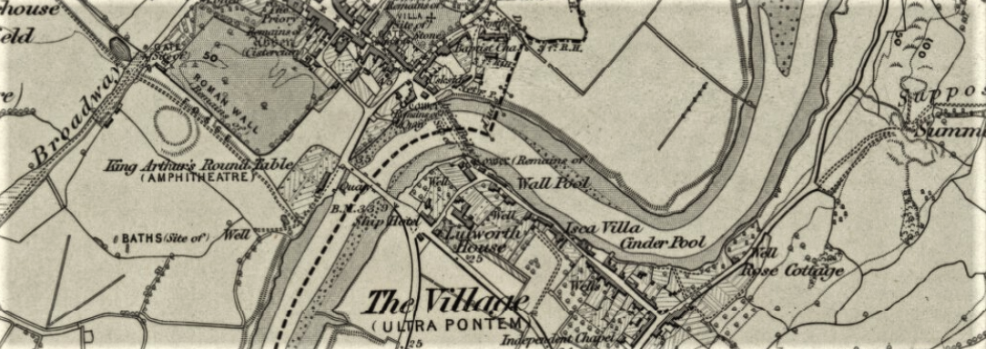
The recent repeat broadcast of Time Team dealt with the investigating the Roman settlement at Caerleon. They mentioned the port there on the River Usk and there was an implication that the Romans used this port not only for transporting soldiers, but also for goods and merchandise. It was also suggested that frequent floods handicapped the operations here and may have contributed to the Romans downgrading this establishment. Caerleon was on the tidal Usk and remained a navigation with a Quay south of the existing bridge. An earlier quay existed above this bridge but below the earlier Roman Bridge.
-
Overshot or breast shot, that is the question- one that is complicated through the understanding of potential and kinetic energy- as well as the fact did the mill engineers have that grasp of understanding the mathematics behind what was best. I believe the study is called Hydrodynamics, where water flow is calculated to decide the optimum type of wheel. Overshot wheels gave the best performance when water supply was limited, as was often the case. Breast Shot wheels became more popular in the 19th century as a water dynamics became better understood. In the context of the original thread as mill streams were being built over long distances, the water supply would have been somewhat limited, hence my observations. However with medium to good supplies of water the breast shot could be the best. With fast flowing rivers the undershot was quite capable for the mill task. It would be interesting to find how many breast shot wheels relied on carried to the wheel by a long mill stream
-
Thanks to all who replied to this poser, I think that is now demonstrated the image is Woodley I attach comments from Grahame Boyes, the present RCHS President, regarding the two tunnels- Grahame was another/co author of the Peak Forest Canal Book; The PFC Committee decided on 2 March 1798 to build the Hyde Bank tunnel wide enough for two boats to pass, but without a towpath – no reason given. The Woodley tunnel is only wide enough for one boat, but with a towpath. The minimum widths at water level quoted in Bradshaw’s Handbook (D&C reprint 1969) are: Hyde Bank 16ft 0in Woodley 9ft 3.5in
-
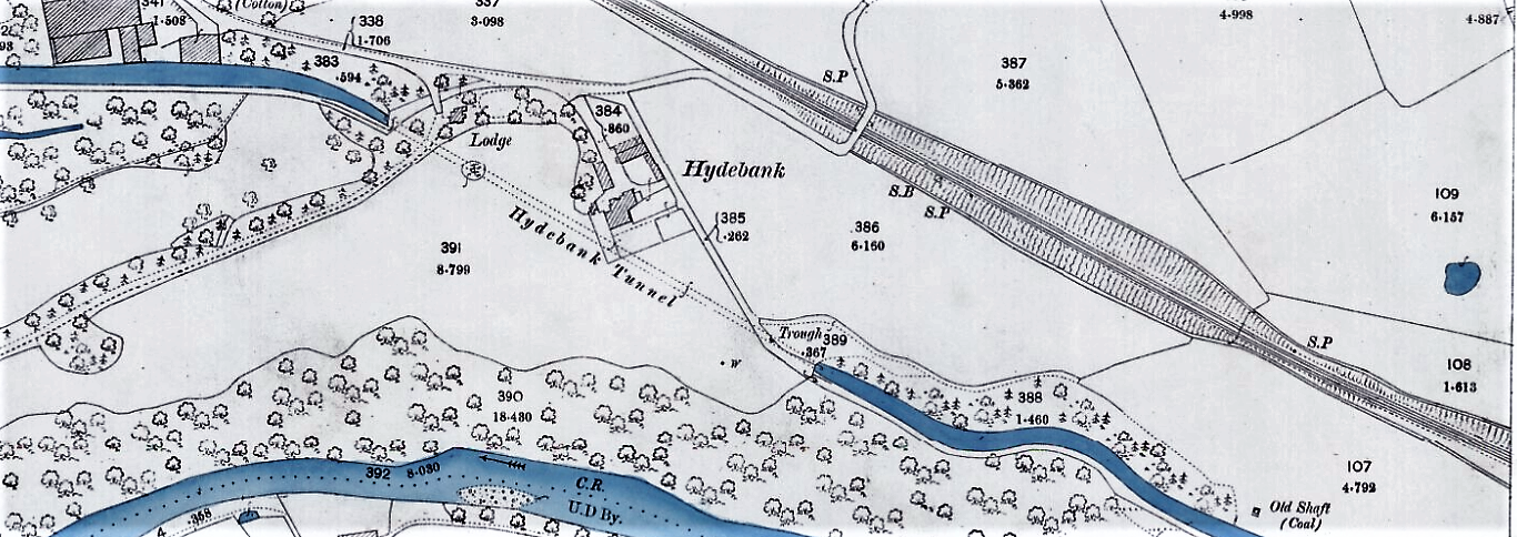
As to Hydebank, this tunnel is named after a location, as is shown on the attached O/S map section (25 in. survey 1896, published 1898), though large scale, there is no indication of a bothy though.
-
William MacKenzie, had a long engineering pedigree, he was associated with the construction of the Deep Cutting, BCN, at Smethwick where a long cutting , 18ft below and beside the earalier cutting of 1788-1791 was done 1826-1829. The link between navigable canals mill streams is a subject that deserves further research. Water powered mills evolved over time with the overshot, iron wheel being a culmination of design as this gave the optimum power ratio. The requirement for making stream, or leats, from a weir to a mill pool or directly onto the wheel could result in cuts up to and over a mile long being made to the mill in order to obtain the required height. Those who engineered those mill streams over at least eight hundred years, created a legacy of waterway construction techniques that were adapted by the navigable waterway builders.
-
It is certainly a poser, the image is taken on a larger format roll film and may be 1928. Woodley would be consistent with the photographer, Bertam Baxter as he was taking photographs in that general area then. It is a loose end tidy up query to be passed on. It is numbered negative 1005 which would be 1928, or earlier. The shortening commented upon may well be due to the type of camera and lens used. I attach a section of the 1935 25 in O/S map. The buildings over the tunnel appear to be in a place consistent with the map evidence. The Smithy on the map is in the same place as the building over the tunnel.
-
The Montgomery Canal has the Tanat Feeder that flows into the canal at Carreghofa and much at present (until the Llanymynech section is restored that is) flows down into the sump level, over a weir at Wern Mill and into the New Cut. From there it flows into the Severn. At the other end of that sump are the locks that climb up towards Newtown where a feeder from the Severn flows in. I would guess both are clean sources
-
Any search of what is written about canal engineers is often complicated by what has become accepted as opposed as to what actually was the truth. James Brindley and Thomas Telford frequently get much credit for achievements, where others contributed and deserve a certain recognition. John Duncombe is a case in point, whose contribution to the surveys of the Ellesmere Canal was considerable. He surveyed this canal before Jessop took charge and it was part of his survey that the aqueduct crossing at Pontcysyllyte was to be 125ft. Duncombe went onto to complete many more surveys for the Ellesmere Canal as plans for the route were altered. He left when his work was done, a year before the Pontcysyllte Aqueduct was opened. He then undertook work in Scotland surveying roads, but died in Inverness Goal, a sad end.
-
Not sure about the facts though- a brief history has its pitfalls. For example the height of the Pontcysyllyte Aqueduct above the Dee is given as a hundred feet. In fact the tallest point is a fraction above 125 feet, as the trip boat guides on Jones the Boat regularly state. I do not think the horse boats that come down from Llangollen are as regular as is stated. In fact at busy times, with boats waiting to pass across this famous aqueduct, congestion can lead to delays in trip boat times sometimes.
-
There are many water sources including streams the flow into the canal network. Both streams and field run off has the potential of being contaminated with what farmers and their stock put on the field. Then there are the minerals in the water such as ironstone that comes into the canal at places like Harecastle and Bilston. To state water is clean is somewhat misleading, I would think.