Scholar Gypsy
-
Posts
5,054 -
Joined
-
Last visited
-
Days Won
2
Content Type
Profiles
Forums
Events
Gallery
Blogs
Store
Everything posted by Scholar Gypsy
-
That depends on the size of the boat. If you are 57' x 7' or smaller then you can go everywhere (with one trivial exception). If you are wider than 7' then you are confined to a number of wide navigations - in four groups North, South, West, East. You can make some connections (South to West, East to North) if you are prepared to tackle short stretches of sea/estuary. There are then a number of interconnecting narrow canals that you can't reach. If your boat is longer than about 58' then progressively there are various waterways in the North that you are excluded from! Road transport is feasible.
-
Thanks to all for their contributions. I hope to post some results in about a month ...
-
Good story! Last time I went through Godmanchester lock someone had dropped a wedding ring. After 30 mins of groping around with his toes (with the lock empty) the owner found it. He was lucky that the lock had a concrete floor and not much silt.....
-
On the other hand it might be good to add the Mersey crossing, and the Wash (and the Droitwich).
-
I agree. What graphics program was used to create it in the first place?
-
Does it have an alternator? That is where most rev counters get the signal from, I believe - the W terminal. (Mine has been stuck for several years, but that s another story).
-
It does look rather neat, but I can't find anywhere that will deliver before February 2016?
-
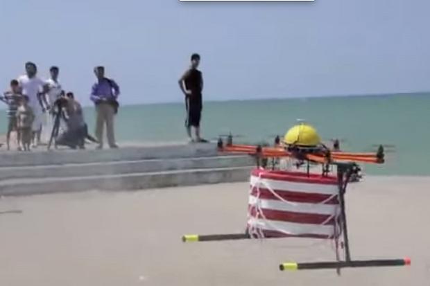
Problem solved - article in the Times this morning.... Lifeguard drones fly to the rescue over Spanish beaches _ The Times.pdf

-
Boat Polish - What do you use?
Scholar Gypsy replied to David Schweizer's topic in Boat Building & Maintenance
Not quite sure how that happened. The engine room floor was out - in a pile on the bank - as I was part way through the list of jobs here. -
Boat Polish - What do you use?
Scholar Gypsy replied to David Schweizer's topic in Boat Building & Maintenance
Ah yes, the ropes. Isn't this is what is meant by springs (see numerous other threads). I was using the wind (blowing from the bows) to turn the boat around, so I could polish the other side. Here's the next one in the sequence ... -
Do you have an accumulator? It's a bottle shaped thing which has (mostly) air in it, and which smooths the turning on and off of the pump, as the volume of air reduces and then increases in a cycle matched by the pump. I wonder if - from your earlier post - you don't, and the pipes to the bathroom were acting like one when they had air in rather than water?
-
Boat Polish - What do you use?
Scholar Gypsy replied to David Schweizer's topic in Boat Building & Maintenance
I was advised by our painter (Dave Bishop, Braunston) to use Autoglym car products. Quite pricey but easy to use: rinse shampoo (the only shampoo we have on board!) rinse dry with chamois polish (special applicator) buff polish with special cloth spray wax wipe off with special cloth -
I'm rather going off my idea of buying a drone ....
-
Except the Compleat Angler in Marlow, some years ago. To be fair we only wanted a pint, we were rather scruffy, and we would have taken up most of the available moorings ....
-
Week to go! Gayton - Coventry - Market Harborough - Gayton
Scholar Gypsy replied to Dharl's topic in Holidays Afloat
The butcher in Braunston is a favourite of ours - and there is a good General Stores on the other side of the road. PS hope your dog is not spooked by the bats in Crick Tunnel. -
I found a good & quiet mooring about half a mile below Delph flight - a bit more character than Merry Hill, which is a bit windswept IMHO. Were you thinking of doing the rest of the Dudley No2 down to Hawne basin?
-
Thank you, some interesting ideas here. I don't think paragliding will work: if the wind is that strong we will be stuck in the pub in Boston. We have tried waterskiing before, with limited success.
-
Upper Thames water shortages / limited draft
Scholar Gypsy replied to Scholar Gypsy's topic in Stoppages
Yes I remember that, esp. Days lock where the water table just kept going down ... -
Not quite yet a stoppage ... Particularly relevant if your boat's draft is over 0.9 metres, and you are above Abingdon. ========================= Customer notice Water levels in the upper River Thames Water levels in the upper River Thames, particularly upstream of Abingdon lock, will be shallower than you are used to in some places, due to below average rainfall this year. With this in mind we are asking boaters to take extra care, especially immediately downstream of locks where the natural gradient of the river means levels are always slightly lower than elsewhere in the reach. For your safety, we have marked all known shallow areas in the main navigation channel (the middle third of the river, also known as the 'fairway') with red and green buoys. Please ensure you are familiar with the rules of navigation around obstructions marked in this way - they are there to protect you and your boat from harm. You may find the diagram on page 13 of the River Thames cruising guide<https://www.gov.uk/government/publications/river-thames-and-connecting-waterways-cruising-guide> helpful. Remember, boats coming towards you may have to manoeuvre around an obstruction even if you don't. Also, other boats may be harder to handle than yours, and their skippers less experienced, so please be considerate. Where we can, we will also mark obstructions that we are aware of, or are reported to us, outside of the main navigation channel. We cannot mark every one however, so do please be vigilant. You can report an obstruction to us on 03708 506 506. Please also remember that a mooring may be shallower than the last time you used it. We are doing all that we can to maintain the depths of navigation as published on www.gov.uk <https://www.gov.uk/river-thames-bridges-locks-and-facilities-for-boaters#maximum-drafts>. Actions we are taking include closing all our weirs and placing 'summer boards' on those that can accommodate them to raise their height. This means we can hold more water back, so raising levels. We are also carrying out additional checks for any leaks in our weir gates and ensuring they are staunched. In addition, we have instructed our lock staff in the Oxford area to try to avoid emptying locks unless they contain at least one boat, wherever possible. This ensures we are making the most of the considerable volume of water that is released downstream each time a lock is used. If water levels continue to drop, it will be increasingly difficult for us to maintain depths, even if we implement additional measures such as restricted lock use. We hope to avoid the need for additional measures but may not be able to unless there is significant rainfall over the coming weeks. Where possible we will also ask our lock staff to advise you of any known shallow areas ahead of you. To help you assess whether or not to continue your journey, you may want to check your boat's draft if you don't already know it. Above Iffley Lock we cannot guarantee the navigation channel will always be sufficiently deep for craft with a draft of 0.9m or more. We are of course monitoring the situation very closely and will let you know immediately if there are any further developments you need to be aware of. We hope you have found this communication helpful in planning your cruising this summer, and hope it is not unduly affected by weather conditions. Thank you for your understanding and co-operation. River Thames Waterway Operations
-
Yes, that's a fifth option. A remote control for the camera is feasible, I think - either mechanical or radio.
-
OK my bargepole then ...
-
I am quite keen to get some aerial photos of my boat during my summer trips, especially while crossing the Wash. So: has anyone managed to land a helicopter drone camera on a moving narrowboat, without it getting wet? Which model (sensible prices only please!)? How? Plan B: use my shaft as a rather large selfie stick, and a radio controlled trigger for my camera Plan C: helium filled balloon, and a radio controlled trigger for my camera Plan D: ask the RAF nicely to take some reconnaissance photos - we are going quite close (but not too close) to the bombing range at RAF Holbeach
-
Engine room hatches on tidal Thames
Scholar Gypsy replied to Painter Type's topic in General Boating
You are right re the lights, and also on not trying to outrun the tugs - you won't win!. In my experience: the tugs always go up with the flood tide - so they will overtake you if you see a light in front of you but not one behind you then there is indeed a boat coming downstream towards you there are a few passenger boats (eg SILVER STURGEON) which are large enough to trigger the Isophase lights. They only go up to Westminster. They also need to get permission from VTS before they do anything - in other words you will get more warning what they are about to do. -
Engine room hatches on tidal Thames
Scholar Gypsy replied to Painter Type's topic in General Boating
Oh and another thing. If you are looking behind you (see above) you may see a flashing white light on one of the bridges behind you. This will probably mean that in about 5-10 minutes one of these jobbies will overtake you (the narrowboat is on the right). This can get quite entertaining if you are both trying to go under a bridge at the same time. At about half the bridges they can take the centre arch (with the flashing white light, which indicates they have absolute priority!) and you take one to the right. It's a bit trickier if there is only one inbound arch: my advice would be to slow down, and if necessary round up close to the north shore and stem the tide until they have passed. -
Engine room hatches on tidal Thames
Scholar Gypsy replied to Painter Type's topic in General Boating
Sounds v sensible - I lovingly made this for my recent Wash crossing, a complete waste of time. It didn't keep the spray out, of which there was quite a bit (compared to normal experience!); and the actual volume of water dumped on the foredeck was trivial.