Scholar Gypsy
-
Posts
4,953 -
Joined
-
Last visited
-
Days Won
2
Content Type
Profiles
Forums
Events
Gallery
Blogs
Store
Everything posted by Scholar Gypsy
-
Actual use of anchors in emergencies on UK canal/river network
Scholar Gypsy replied to IanD's topic in General Boating
It's all a bit confusing. In East Anglia (where most of the Fens are) You've got things called Rivers that are entirely manmade, eg the New Bedford River, The new course of the River Nene, which is manmade things that were rivers that are now really drainage canals (eg the old course of the River Nene, through March) rivers that are a mix of river and drainage canal (eg the Ely Ouse, which is over 4m deep in places), but which are controlled in such a way that at some locations the water level goes down when the river is in flood. Anyway, on any of the Fenland waterways I would not like to fall in without a lifejacket on. PS John Pomfret explains it all nicely here: -
Actual use of anchors in emergencies on UK canal/river network
Scholar Gypsy replied to IanD's topic in General Boating
Me too, since I started doing a lot of single handed boating on the Fenland rivers. It could be days before another boat / person comes past. -
It had pride of place at the front of the Reflections Flotilla last Saturday. There's a photo here https://oleanna.co.uk/2022/09/28/thames-barrier-closed/ , I missed it in my blog https://scholargypsy.org.uk/2022/09/27/reflections-flotilla-post-1-of-3/
-
Actual use of anchors in emergencies on UK canal/river network
Scholar Gypsy replied to IanD's topic in General Boating
It's actually a warning of what can happen if you boat on the Nene without registering for the EA's alerts; and/or neglect to get the stern secured first when you arrive at a short landing stage while heading downstream. -
I have collected some links together here. The Livetts one is I think the best - we saw quite a few drones flying over us, this must be the result. https://scholargypsy.org.uk/2022/09/27/reflections-3-of-3/
-
As others have said a bowline is very handy., eg if securing to a tree. A related point is that nearly all the time I will secure the end of the line to the bank and then tighten up and secure at the boat end. (unless I pass the line through a mooring ring etc and then back to the boat, where it is tied off).
-
Actual use of anchors in emergencies on UK canal/river network
Scholar Gypsy replied to IanD's topic in General Boating
Yes, good point ("the guy" was me, the depth sounder was one of my gadgets). 12m was a more normal depth around Wapping. The Barrier had been closed for the day, and the tidal height was very hard for the EA to predict, I think they had more water than they ideally would have liked. My experience of engine failures (other boats, and the one I was crewing on) on the Thames is that you have a bit of time to try and get a tow from another boat, but if you're at risk of hitting a bridge pier or a pontoon then it's time to deploy the anchor -
Actual use of anchors in emergencies on UK canal/river network
Scholar Gypsy replied to IanD's topic in General Boating
I'd agree on the Tidal Thames using the anchor is a last resort, but should be there as an option. In the convoy heading up for the Reflections Flotilla on Saturday evening, one boat got rope around the prop (not the result of poor maintnance). They called VTS on the radio and a harbour service launch appeared quite quickly to give them a tow while they checked the weedhatch. Anchoring would be the next option. (Here are some photos of the event - nighttime navigation was a little hairy ...) https://scholargypsy.org.uk/2022/09/27/reflections-flotilla-post-1-of-3/ -
Actual use of anchors in emergencies on UK canal/river network
Scholar Gypsy replied to IanD's topic in General Boating
Here's a group of 11 boats that anchored in the Wash a couple of years ago. Not deployed "in anger", but in a planned way (ie lower until it is on the bed and then reverse away from it while paying out the chain. None of them dragged, and all of them were recovered - there was definitely some tide and wind. -
I'll pass this on to Chris Howes, author of the new Imrays guide
-
Tne marina and moorings section here suggests that consent is needed in all cases, even if you are the landowner. https://middlelevel.gov.uk/consents/
-
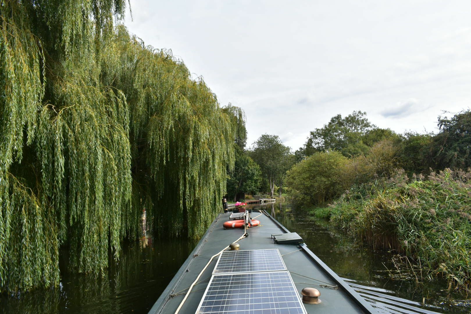
There are lots of houses in March with private moorings, so getting a consent from the MLC must be possible. I wouldn't think of this stretch as a river , it's a highly managed drainage system. For example MLC lower the water level in winter to increase the capacity of the system to move water to the main pumps near Kings Lynn (capacity 100 cubic metres a second!). I agree with the comments about west end , it's well worth a look. I walked to Foxes marina today from the railway station (the route the rail replacement bus took from Peterborough was hysterical....). Here is that stretch of river earlier today.

-
Diamond Jubilee - St Pancras Cruising Club Cruise
Scholar Gypsy replied to Scholar Gypsy's topic in Cruise Diaries & Reports
The timings have changed a bit. Chelsea 1900, Westminster 1930, Tower 2015. That makes more sense to me.... -
Diamond Jubilee - St Pancras Cruising Club Cruise
Scholar Gypsy replied to Scholar Gypsy's topic in Cruise Diaries & Reports
Arrangements are still somewhat fluid (to quote the leader of the NB squadron, as flexible is too rigid a concept). But basically: * about a dozen NBs will depart Limehouse at lunchtime. * The EA are helpfully turning the tide off for the day, by shutting the Thames Barrier. * We will muster, I suspect from about 1500 onwards, near Chelsea harbour, ie between Battersea road and rail bridges. We may find something to moor to, or anchor, or drift around in circles for a while, or pop up to Hammersmith for a pint (no, that's not allowed). * the procession proper, with lots of white illuminations, will start at Chelsea bridge at 1930 (so excellent viewing from Battersea park on the south bank) .. * and finish at Tower Bridge at 2015, which will be lifted * and then we lock in at Limehouse later that evening. In silence, we will be saluting HMS Belfast as we go past (so good views from the north bank at the Tower). The NBs are right at the rear of the powered boat group of about 80 boats, just in front of the Royal rowarge GLORIANA which leads the unpowered boats. https://thamesfestivaltrust.org/reflections-2022/ -
There are some nice youtube videos on how to make them, and how to use them correctly. I bought some at Tradline in Braunston last month.
-
Ah, just like several of the locks on the Regents Canal.
-
Are any of the old narrow locks between Napton and Knowle still navigable?
-
Diamond Jubilee - St Pancras Cruising Club Cruise
Scholar Gypsy replied to Scholar Gypsy's topic in Cruise Diaries & Reports
Oh yes. About a dozen narrowboats in total taking part. -
You're welcome! Angle bridge on the Middle Level. A bit chilly this morning.
-
I meant to say that the upstream transits are fine if Limehouse are still on restricted opening. You'll get to Brentford or Teddington a bit later than "normal", but still before high tide.
-
The other issue you need to check (with the Limehouse lockkeepers) is the hours of operation there. In theory the locks are open HW-4 to HW+4, but for various reasons I won't bore you with they have been restricted to HW-2 to HW+2. This makes the transit from Teddington to Limehouse very challenging, involving (depending on the power of your boat) 3-4 hours punching the tide. If your boat is over 45' you must have marine VHF radio on board. And in my view you would be bonkers not to even if your boat is only 44' long. For Brentford to Teddington you need to book a passage at Brentford (Thames Lock) well in advance on the CRT licencing website. Teddington operates 24/7 and no booking is needed. I do quite a bit of crewing on other's boats for this trip, and am happy to offer advice as I've done the tidal trips quite a bit. Here's a few links that may be useful. http://thamescruising.co.uk/ http://www.boatingonthethames.co.uk/ https://scholargypsy.org.uk/2019/11/12/tideway-trip-from-teddington-to-limehouse/
-
Yes, we got through just in time. The boats stuck behind us (one of whom took that photo) had to wait for a week for the floods to subside.
-
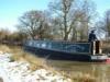
A low footbridge at Bardney (June 2019!).
-
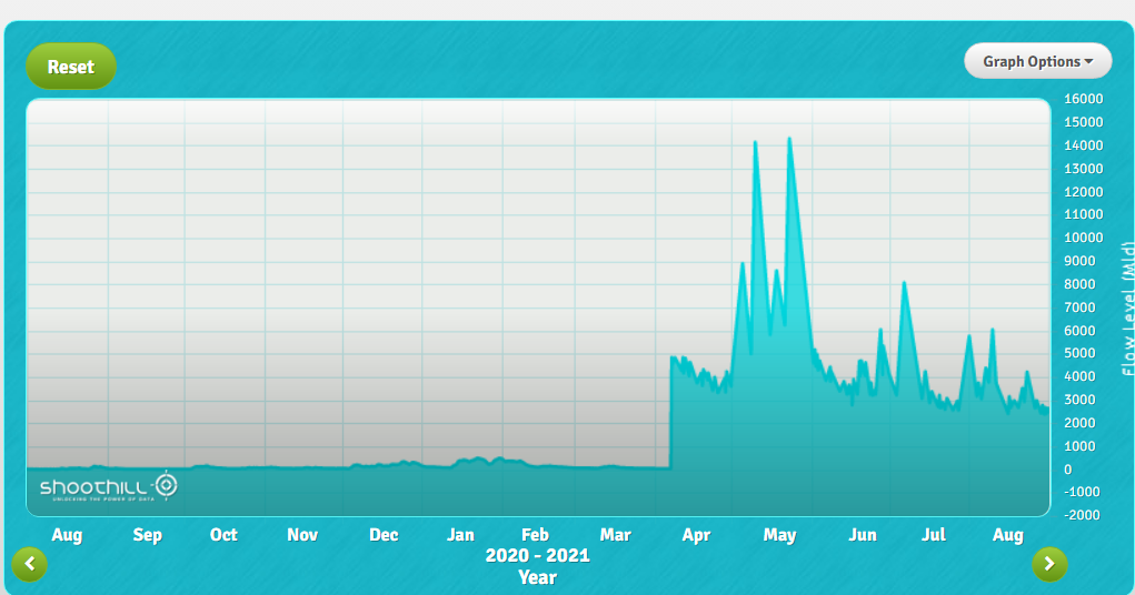
Yes, sorry, I meant to type cubic metres per second. Something very odd happened to the calibration of this gauge in April 2021, I do wonder if the current number is correct!
-
Here's the flow gauge just upstream of Cromwell https://www.gaugemap.co.uk/#!Detail/130/136/2022-08-21/2022-08-27 The current reading is equivelent to about 35 cubic metres [edit: per second] for those who prefer that unit. Small but not zero. In imperial units, it's about 100 acre-feet per hour. More gauges here: https://trentlink.wordpress.com/documents-and-links/