

Heartland
-
Posts
3,397 -
Joined
-
Last visited
Content Type
Profiles
Forums
Events
Gallery
Blogs
Store
Everything posted by Heartland
-
I must extend a thank you to Richard Fairhurst for his detailed explanation. I was keen to hear about the surviving wharf buildings at Oakham and Teigh and looking at "old maps" and "google earth" does pick up on the many parts of the route including the wharf buildings. If I recall the Old Ordnance Survey of the 1830's the locks were at Brentingby and Wyfordby, these areas appear to be on sections of canal not covered by the railway. Being somewhat isolated has anybody looked at these areas to see if any parts of the locks remain. There would also have been an aqueduct over the Eye near Saxby, where the canal route passed to the north of the railway. Ray Shill
-
At the last IWA National, I seem to recall a stand for the Oakham Canal Society which is looking at some form of restoration for this waterway. It is interesting to see such efforts, but how much can be done. In the midlands there were two 1840's canal closures, I believe, through railways being built alonside the route of the former waterway, these being the Oakham and Uttoxeter. With the Oakham there were 19 locks on this waterway that raised the canal from the junction basin at Melton Mowbray to the summit level. The construction of the Midland Railway Syston to Peterborough branch broke up the waterway and reduced what remained to a dry bed in certain parts, but other sections acted as railway drainage channels and might be considered to have retained some water. The making of the section between Melton & Stamford was finally completed in 1848. This work had been delayed following problems with contractors building the railway. The Oakham Canal had not really been a success from completion in 1803 to the agreed sale in 1845 to the Midland Railway. There had water supply issues, and traffic was suspended from time to time through lack of water. It would be useful to discover how much does survive. There are said to be wharf buildings at Oakham, but what of the locks, has any survived? Ray Shill
-
River Severn Publications also produced a book written by Chris Witts- the Severn Bridge Disaster, 25th October 1960, ISBN 978-0-9532711-3-9 in 2010 that describes the loss of the John Harker tanker barges Wastdale H (built 1951 by John Harker) and Arkendale H (built as a dumb tanker barge by Richards Ironworks, Lowestoft in 1937 and rebuilt 1948 as a motor tanker barge). There were 8 crew on these vessels, 5 were lost after they hit pier 17 of the Severn Railway Bridge (in fog and having missed the entrance to Sharpness Docks)and burst into flames after hitting the bridge. These craft carried on upstream to a spot on the mud and sand where the hulks remain, and can be sometimes seen during period of low water. Ray Shill
-
Just that there is no confusion between myself and Laurence Hogg, my reference for this website is Heartland, but thanks to Dereck R for for some useful links. Ray Shill
-
Max Of course is refering to the Henry Michell, later Mitchells and Butlers, Brewery on Cape Hill, which has now been demolished, and I suppose after cycling towards this Brewery one had to turn up Grove Lane to reach the GKN site. It is here where the new Hospital is proposed to be built. I should mention that I raised this topic when the picture of the London Works was published on this site, and the general suggestion was the former GKN works were the subject of the image. However, I have always believed, this image was the London Works in Oldbury. Hence the observation of chance confusion of sites, with the same name. Another example is the location where the Grand Junction Canal Carrying Co steamer, Pincher, exploded Grand Junction Records indicate the locoation of this sad occurence was at Yardley Wharf. This has been interpreted by some as at Yardley near Birmingham with suggestions being made for the Yardley Wood Wharf, Stratford upon-Avon Canal. A newspaper search has found that the explosion happened at Yardley Gobion Wharf situated in modern day Milton Keynes. Ray Shill
-
Just as a rider on what Laurence mentioned, there are two tunnels side by side leading to the BCN main line. The one was simply a basin that terminated under the GKN works site, which the 1919 distance tables call Guest Keen and Nettlefolds Mill Basin. This basin is immediately south of the Cape Arm entrance. If I remember correctly from taking boats past these entrances the Cape Arm had a suspended iron gate at the far end. Does any other boater recall seeing this. Ray Shill
-
Laurence Hogg in presenting an image of the London Works, has touched on an important subject, the use of the name for a location might have an alternative location. The London Works on the Cape Arm was associated with the firm of Fox, Henderson and later GKN, that on the Oldbury Loop was initially the Oldbury Steel and Sheet Iron Co. The later worked up pig iron into wrought. whilst Fox Henderson made structural ironwork such as station structures (and of course the Crystal Palace), before it was incorporated into what became the GKN empire. The long canal frontage in the image is consistent with the waterway that ran from near Whimsey Bridge around the north of Oldbury to rejoin the Old Main Line canal near the Brades, and not the cramped waterway that passes from Cranford Street Bridge to the tunnel that passes under the feeder embankment. Both the Oldbury Loop and the Cape Arm have a common ancestry in that they both formed part of the original BCN Old Main Line. The Oldbury Loop was cut off with the shortening between Whimsey Bridge and the Brades. The Cape Arm became a byway with Thomas Telfords improvements to the BCN (1826-1829). The Cape Arm and the associated long basin came to serve a number of different inudustrial prenises including various ironworks and for a short time a blast furnace. Today what is left of the Cape Arm still runs through the ruins of the GKN site. Part is filled in and all await an uncertain future. This future id said to include a new Hospital, but what of the waterway. What future has this? Best Regards Ray Shill
-
WW2 Bomb damage in Smethwicjk GKN works
Heartland replied to Laurence Hogg's topic in History & Heritage
In concurrence with Martin, I have a copy of this photograph and the source states that it is the London Ironworks on the Oldbury Loop. The GKN works were more restricted in space and such a view would have been more difficult to obtain. Also the buildings on the Cape Arm looked somewhat different to this view. Regards Ray Shill -
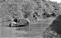
 This is a nice view of a barge heading in the Manchester direction. I would say the photograph was taken from the towing path, now removed. Sue Day from the Horse Boating Society, has requested to have this feature reinstated, but has been refused by the MSC on health & safety grounds.
 -
The Evening Standard Wednesday 4th April 2012, published an artits impression for the development of Fish Island, Newham, as a Riviera complete with yachts and beach volley ball. Presently the site is somewhat different with industrial and perhaps heritage structures, which includes Forman's Salmon Smokery, which was relocated when they had to move from the Olympic Park site. Ray Shill
-
I visited the Lion Salt Works when it was open in September 1998 when on a hireboat from Middlewich. The museum then provided a valuable insight into how these salt pans were used and the industry operated. I moored up there again in September 2010, this time on an Anderton Hire Boat, the works were then sadly derelict. It would be a valuable heritage asset to the canal for this museum to be reopened. May be, it might be useful to make more of the canal diversion north of this point, where BW changed the route of the Trent & Mersey Canal a decision caused through serious subsidence occasioned by the salt workings. Ray Shill
-
Looking at David Macks scheme of events, the concept has definite merit. I can only look at what has been written and what can be seen on old maps. The large scale maps of the Ist Ordnance Survey (1880's) are drawn with such detail that many features are depicted. There appears to be a straight line cut in the grounds of Galton House, that would be consistent with the bed of the old canal, if the new deep cutting was made at this point to the north of it. George Beswick had the contract to cut down the Summit working under the plan as proposed by the BCN engineers. He was cleraly at work on this rask by the summer of 1788. Both local press (Aris's) and proprietors minutes record the lowering 12ft and the opening of the temporary level. Proprietors minutes then mention the intention to cut down the addiitional 6ft. If the wording was taken literally. Beswick and his men, by July 1789 had cut down the level broad enough for a navigation, towpath and presumably spare land to begin the deepening further. Looking through the cash books and company accounts, there were many mentions of Beswick being paid for his services, steerers being paid to move spoil, bricklayers paid for brickwork, and steerers for moving bricks to works and unloading same. Specific details of men cutting are not recorded, like they are in the Oxford Canal records, where it is possible to follow have that canal route was straightened 1829-1834. That is a pity as I was hoping to find a reference in the BCN records of how they crossed sides between north and south at the Smethwick end. I rather think this was done as wooden trough, like the one installed at Smethwick in 1934 when Telfords feeder aqueduct across Stony Lane was replaced by a siphon that passed under the road. That the main cut crossed side with the bulk of the excavation taking place to the north of the canal, as previously suggested, has much to support this observation. Roebuck Lane had been shut off and contractors would have been able to conduct the bulk of the digging there and barrowing the spoil to the old canal for transport, or onto adjacent spoil heaps for subsequent transport, along the major part of the work without disrupting the navigation, so they could cut down the whole intended width there. The feeder from Titford Pools and the back pump at Spon Lane was also maintained in this view so that water supply remained available to the summit. I was concerned to work out how as the cutting got deeper the spoil barrows were brought up to the canal. But BCN cash books have payment for feed for horses used at the summit and the use of gins. The gin was then common in the area and was particularly used in sinking shafts and bringing minerals out of mines. At Smethwick the view can be interpreted that the gins helped the contractors bring spoil out of the deeper cuttings to be loaded into boats. Ray Shill
-
No Nothing has changed. Certain landowners had the power to lead canal companies to divert or hide their waterways in tunnels, cuttings and or fine ( and sometimes extravagent) architecture. Sometimes this left infrastructure problems and sometimes additional cost. Early railway construction encountered similar problems. Ray Shill
-
Just an observation I believe pulley wheels were used to assist haulage, with the boat lines fitting on to the wheel groove where an angle or corner was required to be negotiated. I seem to recall seeing a wheel at Blackburn on the Leeds & Liverpool. Now at Atherstone there was a side basin, towpath side. This had early canalside warehouses and prior to the extension to Fazeley was the terminus of the Coventry Canal. Is it possible that the wheel was required to assist a boat turning into or out of this basin. Ray Shill
-
The comments are certainly of use, however moving the line sideways and then back would require the removal of much more spoil. Yet either that or digging deeper again further sideways may yet be an issue that can be resolved. Ray Shill
-
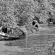
 The narrow boat, appears to have a semi, or portable, steam engine in the hold and it looks like it is pumping water, perhaps from a section staunched of from the rest of the canal.
 -
Yes, I had heard that the contractors for the M5 had encountered lock foundations, but have been trying to find some written evidence or some recorded personal recollection. The fact that these foundations were discovered would assist with the location of locks 7 and 8. Lock 9 is known, and as this was to the north east side of Spon Lane Bridge, I suppose elements of this lock may still remain. The M5 passes over the canal around this point on an elevated section so the excavation for the piers would have discovered the lock foundations. As premises suchs a Kendricks came down to the canalside, the implication is that the excavations found the locks to the south of the present waterway and this fact would help to confirm the supposition that the deeper cut crossed sides to the north and at the summit was on the north of the previous waterway. It has to be remembered that water supply was required to be made to the upper level locks 7, 8, 6 and 5 until July 1789 when it is recorded in Aris's Gazette that water was let out of this level. As water was pumped back by the Spon Lane Engine to top of lock 7 and the Smethwick Engine pumped back to to top of lock 6 and the Smethwick Reservoir also fed water into the Summit at the top of lock 6 some care to maintain this supply was needed. At lock 6 this could have been some form of temporary trunking, as the company intended to completely change the method of delivery to release water at the top of the third lock, creating the Engine Arm at the same time. As Spon Lane Engine was to be dispensed with, was it decided to allow water supply to be concentrated here into the old Summit from the Spon Lane end, whilst the Smethwick End was altered and as this supply was required to be maintained as long as possible this fact determined the excavation to proceed close but to the north of the old line there. Ray Shill
-
The locks at Smethwick on the Old Birmingham Canal Main Line, today comprise a flight of three locks (completed 1790) at Smethwick and the adjacent (now filled in) flight at completed in 1769. At the opposite end of the summit are three more locks (Spon Lane) that carry the canal back down to the New Main Line, but originally served only the Wednesbury Branch Canal to wound through towards Hill Top. When the canal opened in 1769 there were 12 locks and a short summit. Between 1787 and 1790 this summit was lowered with the removal of the top 6 locks (3 either side). According to Charles Hadfield (Canals of the West Midlands) this was done in two stages removing, at first the top two locks either side (8 & 7, 6 & 5) and replacing it with a (temporary?) waterway on the South side of the original line (1789). In this way 12ft was taken off the summit. A year later they took the canal down another 6ft removing two more locks (9 & 4) again south of the original, and presumably the temporary line. The work was done to the design or instruction of John Smeaton, although BCN staff, and other contractors, working under of the directions of James Bough engineer, actually did the work. Essentially the task was in house. The task purchasing additional land for the work was done in 1788 and with the imminent completion of the Fazeley route that had the potential to divert traffic into Birmingham by a new route, work started on the Summit reduction. Dr Jim Andrews has argued that at the Smethwick side the route of the new line passed to the north of the original and that all traces of the original was removed with the making of the New Main Line, and as nobody has invented "fresh air archeology" there is little chance of any trace being found. There was a survey done of the canal in or about 1777, which a copy exists in Birmingham Library Archives and a coloured original at Gloucester. This large scale plan is useful for researchers as it shows the BCN at at early date. It also records a few alterations and around Smethwick it shows, or appears to show, the 1788 land purchases. These are seen as a strip of land south of the original line leading up to Brasshouse Lane and beyond, but then the extra land changes side as the canal reached Roebuck Lane. Both Brasshouse Lane and Roebuck Lane had bridges over the canal then. So did the work of cutting down the summit cross sides? Some 18ft had to be taken down in the end and this is most visible at the tall brick arch at Summit Bridge that has a 1790 date plate (in roman numerals) and was the canal cut here to the north of the original here. Further west of lock 8 the canal could have been cut on either side as spare land was on either side, and it appears the new cut again could have passed to the south of the old waterway and this is consistent with the old lock channel becoming a wharf at Spon Lane from 1790. The main question is this scenerio feasible and the land north of the canal near Brasshouse Lane part of the old canal. Certainly on the 1880's Ordnance survey, the old Brasshouse buildings are shown at a distance from the canal, whilst in 1777 they were beside it. Ray Shill
-
I shall forward a copy today, best regards- Ray
-
I had a look through Railway & Canal Historical Society image records, and came across a photograph which shows the top lock gate at North Road, Glamorgan Canal where the gear on the towpath activated two paddles on the gate. The picture dates from 1950, unfortunately, I find it unclear how to attach a sample image to this site.
-
The Foster & Raistrick Foundry and works has been sadly neglected. According to the Express & Star today 3rd March 2012, the site was to be turned into the country's "largest GP practice", but nothing has been done and time is said to be running out for the present site owners Quadrant Land Partnership. The foundry is famous for the making of the steam locomotives, AGENORIA (for the Shut End Railway) and the STOURBRIDGE LION (for the Delaware & Hudson Railway in America). Less is known about the fate of the other two locomotives DELAWARE and HUDSON also made for the DHR. There is of course all the other railway and canal work John Urpeth Raistrick has associated with, some of of the ironwork came from this foundry. As to the River Stour, this navigation belonged principally to period of Andrew Yarranton, although parts of the river retained a portion of navigation from Pratts Wharf towards Wilden once the Staffordshire & Worcestershire Canal was constructed. And as the S & W canal construction involved re-routing of the Stour any posibilty of a through navigation along the river Stour would seem less likely. Ray Shill
-
Regarding Chillington Basin, this listed structure was constructed between 1899 and 1901 an served as a London North Western Interchange Basin between canal and railway. Before that the earlier basin on this site was a boat dock and interchange basin for the private Chillington Iron Company Railway. There were initially two arms to the basin, but this was later changed to one. Ray Shill
-
The NEC was a quiet place this February after the Spring Fair finished, whilst other regular events went ahead, the normally busy time of moving boats into and out of the halls (and the many caravans and motor homes also)was missing. Ray Shill
-
In Leicestershire Canals, John Anderson, AB Printers Leicester 1983 p16, the post card view of Kings Lock House is dated as 1905, the caption identifies the lock keepers wife as Mrs Swanwick and her son Arthur, with Miss Harrison sitting on the balance beam. at this time Harrisons seed merchants had their trial grounds to the south of the lock house. Ray Shill
-
Soar Navigation- Lock at Abbey Corner Weir
Heartland replied to Heartland's topic in History & Heritage
It is a pity that the third part was not completed. It would useful to see what has been written. I had not seen this account, but had discussed the Soar navigation in general terms with the late Peter Stevenson, a fellow RCHS member. For anybody who wants to contact me on this issue, I can be reached on heartland@supanet.com Ray Shill