Heartland
-
Posts
3,397 -
Joined
-
Last visited
Content Type
Profiles
Forums
Events
Gallery
Blogs
Store
Everything posted by Heartland
-
I am not sure that the term Wych applies in this case, but if it was such a craft then the cargo may well have been salt. In Colin Green's book Severn Trader mention is made of the fact that Severn Trows were regular visitors to the Stroudwater and Thames & Severn Canals. He also states that trows were built at Saul, Cams Cross, Eastington, Stonehouse, Stroud, Chalford and Brimscombe. The craft in the view may well have been built locally. For this reason it is perhaps better to state that this craft was a trow. As to traffic, movement of coal and textiles were two important cargoes. As a side issue the other form of vessels, passing this way, would have been Thames barges that worked from the Upper Thames
-
Making a canal part of a long distance walk attracts more people to do it. And there are different types of people who do it. They may chose to camp or organise accommodation en route. Some simply walk a section, go home, and then do some more, but classifying a canal into the long distance walk category is important and is a form of recognition by the ramblers and other organisations. Besides,there needs to be a balance for towpath use.
-
It was in July 1993 that the Grand Union Walk between London and Birmingham was inaugurated. Is it time for more such walks to be instituted. Walks do touch onto canals in many places, but how many actually follow a canal from end to end? I do not recall if one exists for the Leeds & Liverpool/ Aire & Calder, but if it does not, it would form a canal version of a coast to coast walk.
-
I wonder why Mike chose this post. Was he thinking about Rudyard Lake and that wonderful if not impractical scheme to link the Macclesfield Canal through Rudyard Lake with the Caldon Canal. Now Rudyard was Kilping's first name and there is a poem called "If" by Mr Kipling: IF you can keep your head when all about you Are losing theirs and blaming it on you,If you can trust yourself when all men doubt you,But make allowance for their doubting too;If you can wait and not be tired by waiting,Or being lied about, don't deal in lies,Or being hated, don't give way to hating,And yet don't look too good, nor talk too wise:If you can dream - and not make dreams your master;If you can think - and not make thoughts your aim;If you can meet with Triumph and DisasterAnd treat those two impostors just the same;If you can bear to hear the truth you've spokenTwisted by knaves to make a trap for fools,Or watch the things you gave your life to, broken,And stoop and build 'em up with worn-out tools: If you can make one heap of all your winnings And risk it on one turn of pitch-and-toss,And lose, and start again at your beginningsAnd never breathe a word about your loss;If you can force your heart and nerve and sinewTo serve your turn long after they are gone,And so hold on when there is nothing in youExcept the Will which says to them: 'Hold on!'If you can talk with crowds and keep your virtue,' Or walk with Kings - nor lose the common touch,if neither foes nor loving friends can hurt you,If all men count with you, but none too much;If you can fill the unforgiving minuteWith sixty seconds' worth of distance run,Yours is the Earth and everything that's in it,And - which is more - you'll be a Man, my son!
-
Canalside Schemes- are they built as planned?
Heartland replied to Heartland's topic in History & Heritage
I blame the negative vibes.... But it is true the Walsall deserves better boat traffic -
Safe passing distance for towpath users
Heartland replied to Jon57's topic in Fishing, Cycling and Walking
If a safe distance of a metre is agreed then the required towpath segregation would inevitably result in towpath widening if possible. A barrier system may also be required to stop the rogue cyclists straying onto the pedestrian towpath. With the bulk of canal towpaths such a change may not be possible and so should barriers be introduced, or reintroduced, to prohibit, or reduce, cycle movement? -
Canalside Schemes- are they built as planned?
Heartland replied to Heartland's topic in History & Heritage
Sometimes the drawings and illustrations include features which may have added to the area. Walsall Town basin as proposed in 1993 has features not there now, but which might have been of benefit-
-
Is it time for a new National Waterways Festival
Heartland replied to Heartland's topic in General Boating
For a National to attract the widest group of people decent transport services need to be included. This would include good parking and not the bogged down fields that are found at some sites. Public transport is also an important factor. A main factor would be boat access and a location where boaters have the space to moor up and a good harbour master to organise them. Another factor would be trade stands at a cost effective price. Then there is the society stands that reflect current restoration schemes as well as the long standing societies who have served particular canals or areas of boating. Current events fail to reflect the total spectrum, which the National went farther to achieve. It may need a central location instead of moving around the country, although a nomadic festival does have the advantage of highlighting specific canal issues. If a central location was chosen then there are possibilities in the North East, North West and East Midlands, especially where both wide boats and narrow boats might reach. In this way the major boat ownership would be catered for. I sort of feel that Greater Manchester has possibilities in this regard. There are locations where all groups of boaters might reach and transport by rail and road are good. Yet there are dangers in choosing a central site ans needs re-invention from time to time. The Royal Show was peripatetic for a number of years, and then settled at Stoneliegh. Whilst the RASE are still there the show has now ceased to be! -
If the CRT was perfect, how would services improve?
-
Is it time for a new National Waterways Festival
Heartland replied to Heartland's topic in General Boating
The general comments so far have been rather negative as regards the IWA. But I, personally, have not had the same issues so far. With the sales stands that I ran for the RCHS at Wolverhampton and Burton, there was no real issues and I believe both events were well attended. As to Watford I went there for a book signing on the warm Saturday. It was a difficult site to get to and having walked across the park asking officials (ie park security) there where the boat festival was had the answer "dunno mate". When I did get there, the split site of stands and boats looked to be user unfriendly. I do think that a national event should be organised in the future, if only to focus attention again on a waterways. Whether the IWA should be entrusted to the organisation can only be a matter of debate. But then who else can do it? -
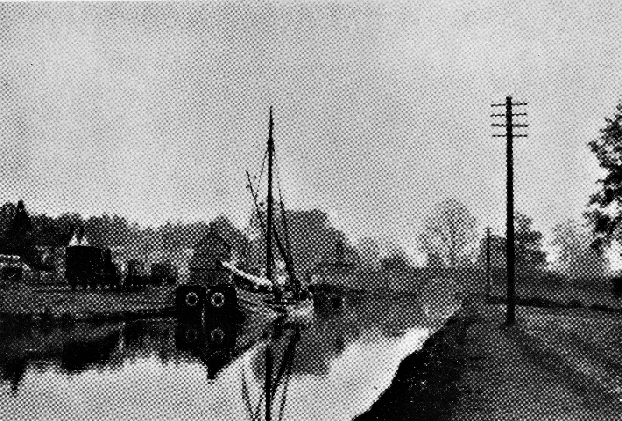
The Stroudwater Canal had a wharf/ basin at Stonebridge. This image shows a Severn Trow and railway wagons on the siding. Ordnance Survey maps show a single siding. The Railway Clearing House book of 1904 mentions the siding as Stonehouse Wharf, Midland Railway. This railway was the Nailsworth Branch and the image of the trow would indicate there may have been traffic from the Severn to interchange with the railway.
-
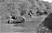
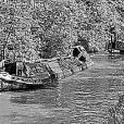
Looking at the image it was registered at Leigh 315? and has the name Mary & Ralph Wadosoe, I think. Leigh registration would imply a boat based roughiy in that area which includes both the Bridgewater and L & L. The amount of collieries in this area would suggest the craft carried coal
-
The IWA National was an institution that brought boaters and the general public together. Organisation, costs and location became troublesome factors in the end and the IWA chose to end what had become the highlight of the canal festival calendar. They were a symbol of the canal restoration movement and a question that can be asked is that movement in decline. Are the many obstacles now facing canal restoration easily dealt with by the internet instead of the face to face dialogue that has helped in the past? Perhaps not, but the issues encountered at Watford appear to have sealed the Nationals fate, but is it permanent? If there is a change of opinion where could a new National be held?
-
Height is not just for boaters, towpath users also encounter varying degrees of height particularly with the traditional bridges are lowest at the side of the waterway. There is also a problem in certain areas where subsidence has affected height above the waterway. Those who look after the waterway have a responsibility to maintain the height so that craft can pass under them. From a heritage issue original bridges were made to the specifications laid out by the canal company and engineer. Since that time there has been a host of different types ranging from railway to modern road types. They all appear to maintain a safe height over the navigation and it would be of use where boaters indicate where this is not the case. The worst cases of height is where a navigation is blocked by a new bridge such as happened on the BCN at Swan Village where the Black Country Route cut off navigation onto the Ridgeacre and denied boaters of a useful mooring beside the Pub!
-
There is still a requirement, even in 2017, to have coal brought by narrowboat to isolated canal locations. It would be useful to know where. I have seen boats making deliveries in the North West in recent times and this is the time of year when it was done as cottages stock up for the winter. Yet with all deep coal mines closed, where is the coal brought from? Heritage Railways rely on foreign coal and as new steam engines are constructed eg a PATRIOT at Llangollen and P2 at Darlington, there will be a demand for coal. Working boat owners sometimes get involved in moving coal to the Heritage Lines. Such was the case when at the time of the IWA National at Peterborough GREYHOUND was photographed by Mike Arnold delivering coal to the Nene Valley Railway:
-
In 2001 a scheme for Tower Wharf at Chester was proposed which looks very little like what was made. In Birmingham the intended Icknield Port scheme has yet to happen (and the site is simply an eyesore), but if built will it match the published artists impressions. The Tower Wharf sketch shows the following:
-
Interesting Pulley at Atherstone Top Lock
Heartland replied to Graham and Jo's topic in History & Heritage
It is 1958, The original is now with Pluto, maybe the card, the postcard size photograph is mounted on, has more detail -
I agree with Patrick Moss, fastening a structure like that proposed at Slateford is detrimental to that heritage structure as is the proposed high rise cycle way in the basin at Edinburgh. As to cyclists I have a certain tolerance, as some behave responsibly, not all though. The husband of the late Kim Briggs must also have similar feelings about the reckless behavior of a growing number of cyclists. The proposed improvements along the Union Canal may have the intention of improving safety, yet in bringing more chance of speeding along the towpath may not be the best use of funding.
-
Interesting Pulley at Atherstone Top Lock
Heartland replied to Graham and Jo's topic in History & Heritage
Ah, but looking at older images of Atherstone Top Lock and the basins associated- could it be for of use for assisting craft into the lock. Attached is a image from the RCHS Hugh Compton Collection showing basin on the towpath side and opposite. Atherstone was the terminus of the Coventry Canal before the canal was completed to Fazeley and the basin had a warehouse for the merchandise trade. Coming out of this basin and making a turn to descend the locks no doubt required assistance. C Faulkener was the photographer
-
Comments of value, although I believe the view of the picture attached in the first post is looking across the Thames to the south shore Ordnance survey for location 1913, published 1915 is attached:
-
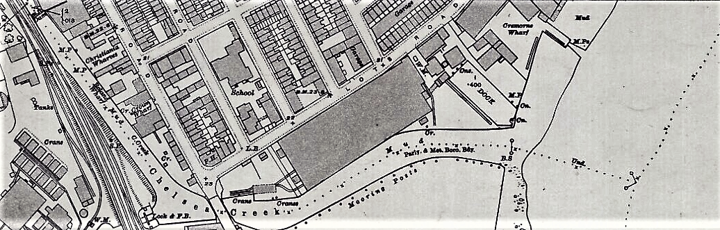
The London Underground received its principal power supply from a power station at Lots Road in Chelsea. Thames Barges brought coal to the basin that linked with the River Thames, yet it seems that Chelsea Creek may have been used to access a wharf west of the main turbine hall. Over head Telphers were used to unload the barges and the coal was burnt in boilers to create steam to drive the turbines. The ash was taken away by lorry or barge and it appears the Chelsea Creek wharf was for the ash transport. The unloading basin appears to have been quite large:
-
A recent report on improving cycling along the Union Canal in Scotland has received finance from Sustrans and looks at the ways the towpath might be improved for cycling including alternative routes around tight spots. The IWA in their latest newsletter is concerned that some suggestions if adopted will be at the detriment to the boaters. There is a proposal for a new cycle route bridge, the Slateford Snake, between the aqueduct and railway viaduct in Edinburgh.
-
The former GWR goods shed is also seen
-
Carrying by water involved transhipment of goods at strategic places where there was a change of craft. Most common were the wharves where wide boats interchanged goods with the narrowboats, Such locations includes places like Stourport and Shardlow or in the coastal ports where craft loaded or unloaded alongside sea going vessels. Yet, there cases of transhipment where the different boats never shared the same length of water, In Gas Street Birmingham, Worcester Bar was a point of transfer between the BCN and Worcester & Birmingham before the Bar Lock was made, At Pratts Wharf on the Staffordshire & Worcestershire Canal goods, particularly iron, were taken across the wharf to the Stour for carriage to the Wilden Ironworks, before the lock there was built. A similar situation existed at Willington where there was transfer between the Trent & Mersey and the River Trent. Another case was the Hollingwood Common Tunnel Canal that brought coal to the Chesterfield Canal. Can members provide other examples?
-
The Gala Website is offering bookings for 2017! https://www.galahotels.com/en/Hotel/united_kingdom_1/.../floatel_hotel_163984