ChasH
-
Posts
4 -
Joined
-
Last visited


ChasH's Achievements
")
Gongoozler (1/12)
1
Reputation
-
Several of the tie bars were found to be broken on this stoppage occasion, when the lock wall suddenly moved by 6 inches overnight. The tie bars were all renewed to steel bars with bottle screws, so that they could be re-adjusted in future if nessecary. There are 2 sets of tie bars at different heights on each vertical beam, and they are anchored to massive baulks of timber running the full length of the lock. The picture shows towpath side, but some years later a test dig was made on the offside wall, as this was leaning in somewhat. This revealed totally sound tie bars (non-adjustable) anchored to a railway line longitudal structure. As it was all sound, it was deemed best to leave well alone. Hence this wall is still leaning, due to the sand hill. I can confirm that the gate paddle was fitted due to the slides on the ground paddle having corroded away, making it in-operable. This was sorted later when the new wooden gates were installed 2013. Incidentally, the current overflow weir is not original but added later. The original was on the towpath side, where there are 3 slots in the iron wall in the headbay area, with an iron pipe emitting below the lower landing stage. The staircase locks would have been further back, probably fairly close to the cottage. The driveway across the field to Stone Lock is along the original canal bed. Before the "accessible" towpath ramp was built there was a distinct curve in the towpath hedge where the towpath swung round a fairly sharp curve after leaving the staircase locks to get under the (smaller in those days) bridge. If anyone has any pictures of the old canal bridge here, from canal level, or of Beeston Wharf, I would be very interested to see them. There are several pictures from road level showing both old and 'new' bridges available.
-
Apologies to 'Rob' for mis-naming him. He actually turned up at our boatyard last year and was very happy to see his old boat being cared for. Thanks to Peter Harrison for the requested information sent.
-
Many thanks Pete. This fills in a few gaps. Rob Robinson didn't keep it for as long as you say cos I was steering it in 1967-8 as a Day Trip boat in Nantwich area. The owner a Dick Edgeley from Crewe had bought it from Rob at least 2years previous to this and put a lightweight wooden full length cabin on with roll up side curtains. I purchased it from him in 1972 and ran it as a camping boat till 1976. I have done much renovation and rebuilding since then and have lived permanently on board for the last 35 years.
-
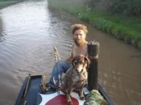
I see mention of my narrowboat "Dorset" being used on the Rochdale Campaign Cruise in 1960s. There is also a very good pic of this boat on the Stourbridge Canal in Garth Allen's 'The Battle for the Stourbridge 1962, with a young man (Peter Froud?) and 2 Staffie Bull Terriors on board. Can anyone tell me approx what years Peter Froud obtained, from whom, and then sold this boat? I believe it passed into the hands of 'Rob' Robertson who later had a pontoon called "Shed" that he dragged around the canal system by hand. Any other previous history would be most welcome. I know it was built by Anderton CCC in 1937 and probably carried tar products from Chatterley to Oldbury. Would love to know more early history. ChasH