toms1
-
Posts
60 -
Joined
-
Last visited
Content Type
Profiles
Forums
Events
Gallery
Blogs
Store
Everything posted by toms1
-
Getting there - here's a mock up of the new app - interface will change - trying to get my head round material design using Flutter and Dart. Got something running on the emulators now. https://explore.opencanalmap.uk
-
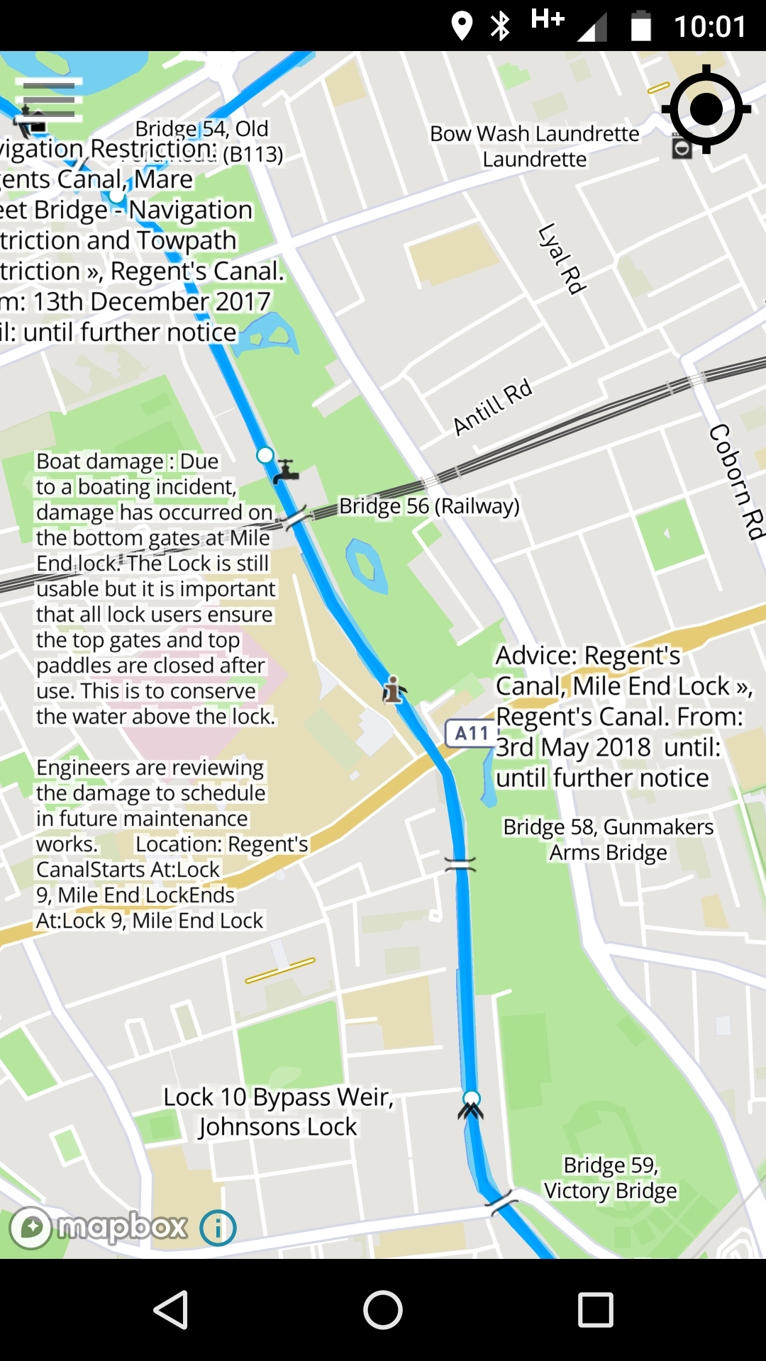
Haha - I can't even get to the sanitary station at the moment - locks are all padlocked... It's quite peaceful without the hire boats though... Just added the "Advice" info too. Going to try adding the opening times - hoping it doesn't make the map too crowded.

-
The map is made possible by CRT's recording and release of Open Data plus the stoppage information published by CRT - true their maps are a bit shite - hence I made this. BW never had any map on their website - just looking at the positives rather than complaining about signs... sigh...
-
Just added CRT Stoppages to Open Canal Map - they are automatically imported daily at 9:30am and published at 10:30am. They include all stoppages and restrictions valid over the next 30 days. crt stoppages map is updated daily at 1030am Live Canal and River Trust Stoppages Map for iPhone and Android
-
Stephen Doyle has put together a iPhone version of Open canal map - more about it here https://opencanalmap.uk/2018/05/31/download-the-iphone-ipad-version-of-open-canal-map/
-
I think that is the stumbling block. How does it know when your boating and not walking the dog etc...
-
Interesting idea. Would need to think about privacy of the data - could give location away if done badly. For me knowing the number of locks, movable bridges and miles to destination would give me more of an idea than the time. We're quite slow so a canal plan 5 hour day usually takes us 7 hours - I think of canal plan as the fastest possible time. Maybe the app can learn your dividing factor for time - in this case mine would be about 0.7 - but can change depending on how many crew / sharing the locks with another boat etc... That factor could feed into canal plan perhaps.
-
Yep - that's what I've done... https://opencanalmap.uk/2018/01/22/loading-canal-plan-ac-files/
-
Yep - the camera was just to do something simple with the data. Trouble with it is that it will end up showing a countdown of locks to your destination - which could be quite depressing...
-
Not in beta yet I'm afraid - just a video preview. Needs a bit of work to get it ready to release.
-
I've made a import function for Canal Plan AC csv files - it just follows the route with the camera at the moment but could display the journey times too. No point putting a route planner in the app when CP can do that. https://opencanalmap.uk/2018/01/22/loading-canal-plan-ac-files/
-
Ok - I've registered on your site - but can't post - maybe needs approval.. Yea I didn't really research what data was out there when I started this. I just came across the CRT open data then CanalMap.net contacted me on here and now I'm using his data too. A central repository for the data might be an idea. Michael who posted about his project earlier in this thread has sent me a rather impressive bit of javascript that uses canal plan data to calculate journey time on the fly. This can easily be incorporated into the app if you and Nick were happy for that to happen. I'll check in the canal plan forum tomorrow and see if I can start a discussion about it there. Cheers.
-
-
Good idea about getting the google map to open in the same place - just figured out how to do that - I'll include that in the next update to the app - cheers There is a API to connect to CanalPlan I believe - don't know if they would mind me adding that - primary focus is on building tools to let users update the maps first off though.
-
Yep - there is a load of info missing because they're not clickable yet. To make it work that way they need to be stored separately as a table in the app - so that is the next thing to work on. This will then lead into the function to add and edit the markers. There is a way to query Google to find nearby places - I'll look into that at some point too - but then again I'll never be able to duplicate all the functionality of Google Maps - so maybe not worth doing.
-
Might just be a time lag kind of thing - when I update in Mapbox it takes a while for the changes to appear on my phone - like maybe an hour or so....
-
Yea - I think the last update where the storage path was changed will of broken some downloads. Previous updates seemed to retain the downloads but that one changed the "OfflineManager" code - I'll leave the core of that stuff alone from now. I'll try and figure out where the data is - I don't know where it puts it - bit of a black box
-
I've done a couple of updates to the map: 1. Locks now show at any zoom level - collisions are ignored for the icon but not the text. 2. The double / triple line of the canal / waterway has been styled out - these paths are now used only in lower zoom levels (zoom out) but the open street map canal route is used when you approach high zoom levels.
-
If the memory is amalgamated then there is probably no need for it to save to SD. I've tested on android 5 and it did as intended. I don't think there is a way to get it to store the application itself on external. All I've been able to set is external storage as a preferred location for data. Might mean it needs a reinstall to start using that as the place since it can't store data in both internal and external storage at the same time. So if you already had data it would carry on using the internal storage. Just to clarify 'move to SD card' option should be disabled but the app should save cache and downloads to external store if it can. Fallback is internal storage for data. Best it lets me do for now I'm afraid unless I can find out otherwise.
-
Yes - the intention was to have locks as the highest priority, swing bridges should probably be second, followed by the taps and then moorings etc. - I'll alter the zoom settings on the other features a bit more to hide them on the medium zoom levels your referring to. There is a lot of control over how things are displayed - but therefore also a lot of settings to mess about with to get it right.
-
Just release another Beta - this one should save data to your external storage (SD card) - took a few attempts to get it working but seems OK now.
-
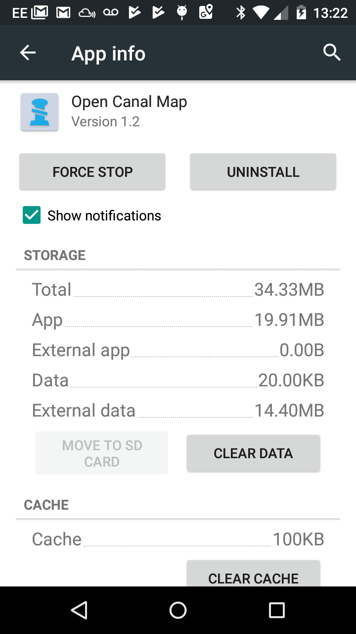
Just published an update to the map - no need to update the app - some areas might be cached in your device - either just wait or you can clear the data in Settings -> Apps -> Open Canal Map -> Clear data - but that will remove any downloaded maps you've created.
-
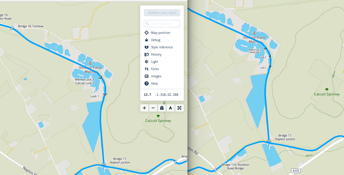
I had some transparent space around the lock icon - removing that and scaling the icon down with the stylesheet seems to reduce the number of collisions.
-
Ok, this sounds like it's just marker collision. The Mapbox library hides markers when they overlap. I just tried adjusting the SVG icon and changing the font size based on zoom. Have managed to get the 3 locks to appear where they would not before. I'll tidy it up and update the main map.
-
If you can give me steps that recreate an error consistently then I can try and debug it and see if I can fix or at least submit an issue on the github mapbox repo. Thanks for all the feedback. I'll be looking into the storage stuff next.