Tarboat Tim
-
Posts
14 -
Joined
-
Last visited
Tarboat Tim's Achievements
")
Gongoozler (1/12)
9
Reputation
-

£16 million funding announced to restore Montgomery Canal
Tarboat Tim replied to Tim Lewis's topic in Waterways News & Press
Wonders of modern technology! Be fascinated to see what you find.. Cheers. Tim -
£16 million funding announced to restore Montgomery Canal
Tarboat Tim replied to Tim Lewis's topic in Waterways News & Press
Agreed Graham. If ever I’m in that part of the world I’d probably pull over and check it out myself. Mind you, estimating slight rises and falls to these levels of accuracy, when the canal is some distance away, really needs the proper kit I suspect. Still, there’s no harm in having a good old look at it 😉 From my perusing of the OS map, I’d estimate the canal level to be somewhere >90 and <95m. Best guess around 93-94m. If u ever do have a gander at it, pop it on the end of this thread! Cheers. Tim -
£16 million funding announced to restore Montgomery Canal
Tarboat Tim replied to Tim Lewis's topic in Waterways News & Press
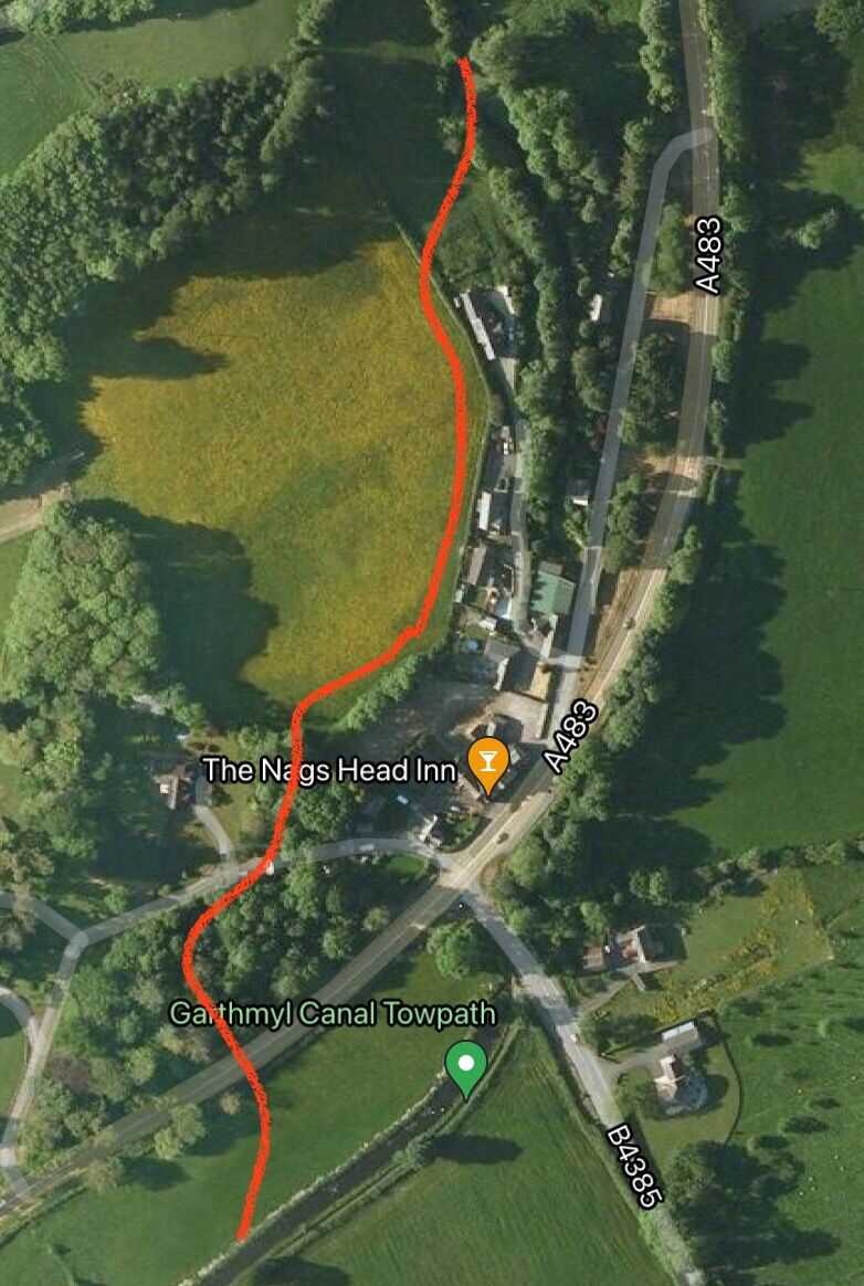
Graham, absolutely agree that the Garthmyl 2 dropped bridges + 150 - yards of vanished canal is the worst blockage on the southern bit before the dry section at Newtown. There seems to be no way it would go back on the original alignment or anything like it. What I have seen mentioned as the subject of semi-official discussion in the past are alternative routes such as sketched by myself in the appended picture. From an engineering perspective the road is slightly rising going south, and there may be JUST the required headroom under it for a crossing without any unacceptable (highway requirements etc) uplift. As OS contour maps are to the nearest 5m I cannot be definitive on this, but I’m repeating what others have said. From a property perspective it cuts through Hall lands and crosses one of the two drives into the Hall, necessitating a lift bridge, I imagine. I’m not sure how that would go down, but we’re not in the 18th and 19th centuries where landowner rights could kill such a proposition stone dead. Perhaps outline very early soundings have even happened? I have seen versions of this rough concept being mentioned by sources I respect on a number of occasions, so I currently believe that it has some merit… but nothing is certain. Regarding the two 483 crossings further south at Fron farm, they also provide challenges but you have started to pencil in one engineering line of attack. My worry about the approach of staying on the East of the 483 with a new 1/2 mile length of canal, is that in the area roughly opposite the farm, the field is perhaps 4-5 m lower than the canal, necessitating a considerable embankment. I suppose the good news is that makes the side road crossing easier, but it is substantial work. The two existing crossings might be viable if they were moved short distances along the 483 to gain headroom. However this would be two sets of crossing works, and very touch & go on height as well. There might also be issue with property at one of them. So overall I’d guess your suggestion is the most likely - certainly it would minimise road disruption. David, I still shake my head in wonder at Tuel lane - we’ve boated through it a few times with our 70’ Tarboat, and it just shows what CAN be done when the chips are down. A positive lesson for us all, and it shows the focus that can be brought to bear when one gets into ‘last remaining obstructions’ territory. I still have an abiding admiration for the parties involved who managed to make that happen. Look at that and then think Arddleen - or even Garthmyl - not so depressing after all, perhaps ;-). True it was in a different time and things are flatter/slower at present, but the good times ebb and flow, and the worst that seems to happen in the bad times is that things slow or nearly stop. We don’t seem to go into reverse anywhere in the country (other than the Dearne & Dove which I think has finally gone). I take some heart from the re-affirmation implied by the recent Uttoxeter canal planning refusal decision. The Manchester end of the Rochdale is only just there. So much of the lottery money had to be spent on a small number of major projects that they nearly ran out on the funds for the track itself. That’s one of the reasons why chunks of the water channel still exist on the offside along some of the length, and you need very precise instruction with a deep boat to get along some of the pounds. So, tricky, post-industrial, heavily locked, it is and will always be lightly used. A poor cousin to the eastern half, but still a great gain to the system. Take care guys 🙂
-
£16 million funding announced to restore Montgomery Canal
Tarboat Tim replied to Tim Lewis's topic in Waterways News & Press
Umm, partly true, yes. But the Rochdale was restored from East to West, with the restoration halting Around l’boro IIRC, until a great wodge of lottery money arrived and did the rest into M/cr in a Big Bang. However, if the Eastern half hadn’t already been done, the case would’ve been a lot harder to make. The Huddersfield was, essentially, one Big Bang of lottery money start to finish. OTOH the Mont is shaping up to be a classic ‘isolated bits’ approach, although it will become more focussed as the bits get closer to linking up - as I suggested above the pressure to fix the Arddleen mile will become v great once that’s the last barrier to reaching Welshpool. However the point I was making was that the necessity of starting with the easier bits can, later, add momentum to dealing with the nasty bits of any restoration, as the payback once they are defeated is much bigger than just that 1/2 mile of canal or whatever. So what looks wildly over-ambitious when one is prodding at the first unrestored lock on the Rochdale (“We’ll never get it restored through Manchester…”. I remember the alcoholic discussions) becomes just a hard thing that now needs doing when that’s all that stands between now and a fully open canal. Newtown’s time will come. -
£16 million funding announced to restore Montgomery Canal
Tarboat Tim replied to Tim Lewis's topic in Waterways News & Press
One of the interesting things about progressive canal restorations (a bit at a time then argue about the next bit) is that how what seems possible changes with time, for better or occasionally for worse.. In this case, thinking about the Newtown length with all its difficulties, isolated and an awful long way from where a network boat can get to, the possibility of restoration seems remote and a little other-worldly. OK, that’s as maybe, just keep the line protected (which Newtown council seem to be very clear about). Then fast forward and imagine a fully open length to Refrail or even Garthmyl, with an intense “Time for Newtown” type campaign, rallies etc. Add to that Newtown council with the hots for it all. Suddenly it moves up funding bodies priority lists, Severn Trent start negotiating, etc etc. When the thing is banging on your door its real-er than when it is a theoretical possibility, and it sharpens the bureaucratic mind. Same thing is happening with the phasing of the Cotswold canals - you can get far more momentum for the Herculean tasks of dealing with Sapperton etc if you have that as the only thing left preventing opening. Incidentially, going back to the Mont and Arddleen, if no funds are forthcoming in the interim to do the tricky mile and its bridges, one waits until the restoration from Crickheath meanders its way thro Schoolhouse bridge and onwards through Pant until it links up with the newly restored £16m section at Llanymynech. Then all of a sudden Maerdys Bridge is the end of the network section, and the full force of ‘We need this last bit to get to Welshpool’ can be brought to bear with all the rallies and other arm-twisting. So one might call this ‘Progressive Pressure’ strategy plan B for Arddleen, if funds are not produced beforehand. And very probably plan A for Newtown. The only trouble is - it’s so slow!! Cheers. Tim -
£16 million funding announced to restore Montgomery Canal
Tarboat Tim replied to Tim Lewis's topic in Waterways News & Press
Hi Graham, I agree about the road - I think the drop lock may be the only game in town, but I detest them. Two separate locks with a 100-200 yard pound between them would be much easier to work and safer, but would cost more to do. So we’ll get a 7’ version of that abort**n in Glasgow. Running towards Newtown - nah, it’s a goer. If you take a look at the challenges that the Rochdale and HNC got over/under/around, this is small beer. The 483 crossings are a bit nasty, and the worst is the first going south. The route there has already been identified, dont go under the road there, go another 150 yards or so south, where the 483 has climbed, then go under it. Doable but not particularly cheap. The other two crossings I only have a hazy recollection of, but IIRC the carriageway is quite a lot higher than the canal, so driving a ‘tunnel’ thro underneath is, again, viable. I seem to remember that along that length the road embankment has also taken up part of the canal - that will need some sorting out as well. There are lots of other bits and bobs, missing piped min-aqueducts etc, but no real deal breakers. Entering Newtown the bed is drained & filled in, and sold off. However not really built on until you get to around Cymric Mill when it used to leave the side of the river and head into the terminal basin complex. That last few hundred yards has gone. The rest has been kept pretty open, largely preserved by that cycle route. Newtown council is also bound and determined it will get there one day, so the odds on getting planning permission for further development on the line are slim to none. It’ll happen, I do hope I stay around long enough to see it!! -
£16 million funding announced to restore Montgomery Canal
Tarboat Tim replied to Tim Lewis's topic in Waterways News & Press
Actually, I’m pretty optimistic about the long term prognosis for getting all the way, even to Newtown. It just doesn’t happen as fast as I would like. I know I may get to Arddleen on my boat, probably Welshpool, but whilst one day I have little doubt the boat will get to Newtown, I really doubt I’ll be on it. I am intrigued about what might finally be done at the Newtown end when it finally gets that far (maybe 20 yrs from now?). The original basin is well gone, but there is a little field nearby, or maybe something more exciting on the banks of the Severn?? -
£16 million funding announced to restore Montgomery Canal
Tarboat Tim replied to Tim Lewis's topic in Waterways News & Press
Hi David, one could. I was thinking that the track bed was a lot lower than the canal and passed under the 483 in a real culvert. Just checked and I must’ve been dreaming! It runs maybe 5’ lower than the cut, but is as thoroughly obliterated as the Canal is by the 483. So probably they will stay with the line of the canal, unless there are some secondary reasons for moving slightly to one side (eg keep the water flowing through the extant culvert, less hassle keeping the works dry until ready for flooding, etc). Regarding raising the road levels, above my pay grade that one. If you want more guesswork as to why not I’d suggest the answer lies in the following points: 1. Acceptable sight lines for a high speed road (60 mph there??) around that junction 2. Length of the ramps required to provide these and comply with current regs. Leading, I assume, to £MM price tab, way higher than £1.6m (never mind all the bitching about congestion during the works etc) Now the cynic in me growls at these arguments, cos if the Mont had been open when they wanted to put the 483 through (the current alignment is new from the last set of improvements) they surely would’ve found a way of doing it. -
£16 million funding announced to restore Montgomery Canal
Tarboat Tim replied to Tim Lewis's topic in Waterways News & Press
David, Indeed, quite so. The first crossing - and the new canal that has to be cut, plus the new lift bridge on the B road - actually adds up to a lot more that the dratted drop lock they are proposing for the southern crossing. In 2016 money £3.75M for the ‘Northern’ works, and £1.6M for the drop lock. I suspect they may be planning to put the drop lock on the site of the old railway that passes under the 483 just next to the canals, but that’s just a guess. Matty - there’s a lot more work here than on that roundabout. Two major road bridges, one drop lock, and around 1km new canal -
£16 million funding announced to restore Montgomery Canal
Tarboat Tim replied to Tim Lewis's topic in Waterways News & Press
What stops them putting in a longer diversion so the canal no longer crosses the A483? Good question David :-). Unfortunately, the answer when you look at an aerial view or the OS map is easy to see: Arddleen. The village lies between the two secondary roads and is packed in pretty dense. No way through for the cut, and IIRC the land rises slowly as you move westward, so a ‘grand deviation’ around the back of the village wouldn’t be on the cards as the land would be too high. -
£16 million funding announced to restore Montgomery Canal
Tarboat Tim replied to Tim Lewis's topic in Waterways News & Press
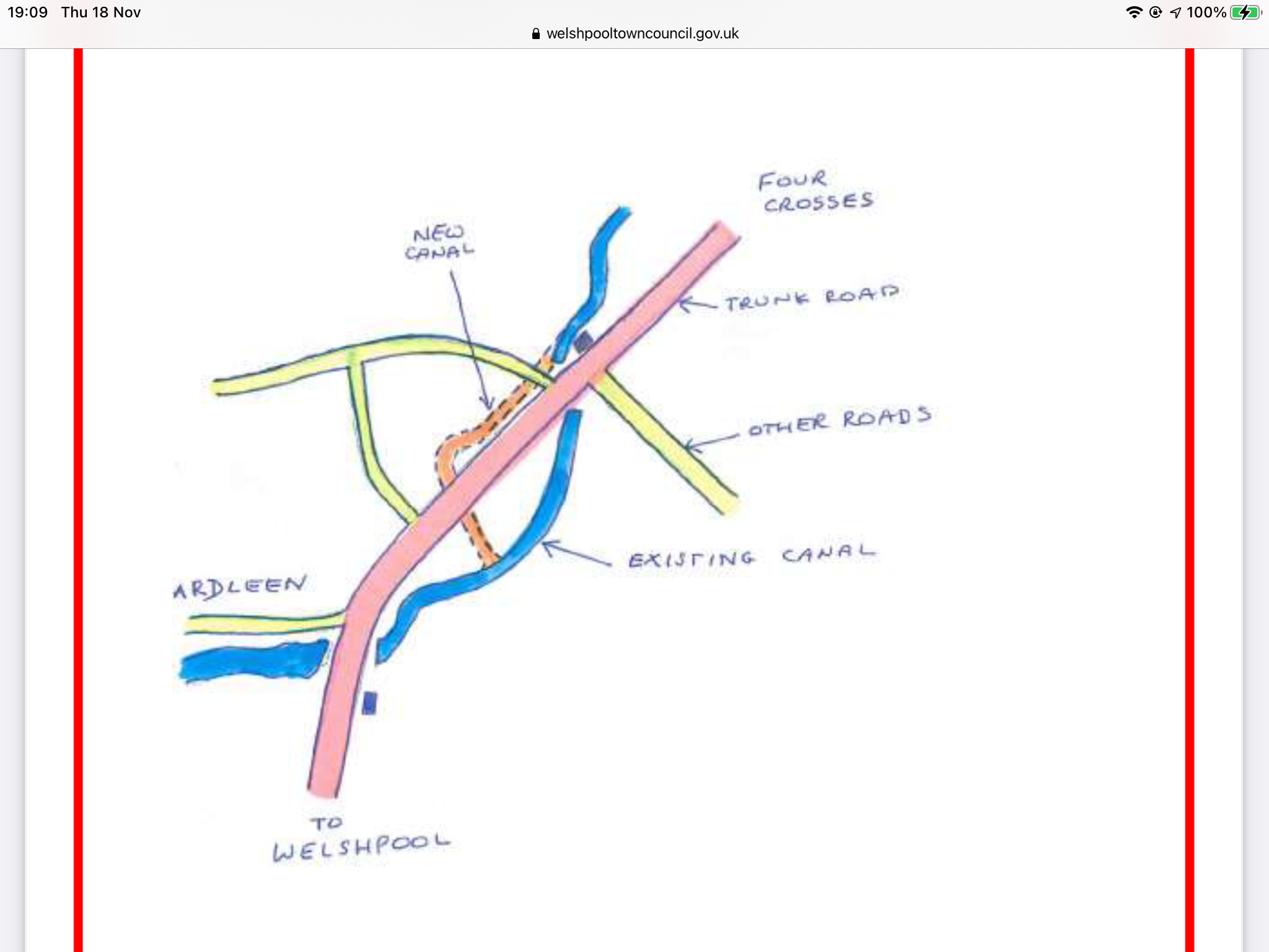
I hope I’m not being negative, but I am frustrated with the official silence on the detail. My frustration has been heightened by the superficial ‘spin’ that has been applied in the loose reporting around the subject. Being charitable, I’ll assume it’s caused by uniformed laziness on the part of some of the reporters involved. In a number of instances it has been reported that the existing isolated length goes to Arddleen, and the new funding for restoration from Llanymynech also goes to Arddleen, so - bingo - when this new money gets spent, everything links up. In fact, some of the most key bits appear to be out of scope. Frustrating. I’ve added a detail map from the Welshpool Town Council (2016) published report below, showing the plan at Arddleen. The new lift bridge will be needed on the minor road on the diversion, the egregious drop lock on the lower re-crossing of the A483. Cheers. Tim
-
£16 million funding announced to restore Montgomery Canal
Tarboat Tim replied to Tim Lewis's topic in Waterways News & Press
Agreed. It’s on a side road. -
£16 million funding announced to restore Montgomery Canal
Tarboat Tim replied to Tim Lewis's topic in Waterways News & Press
In 2016 a fairly brief and somewhat simplistic report published by Welshpool council (https://www.welshpooltowncouncil.gov.uk/documents/user/CANALCONSULTATION-ADOPTEDPLAN.pdf) estimated costs were provided for the various outstanding works. The Arddleen ‘link’ was at that point estimated at £5.35M. In 2022 money, adding a dash or realism as well, I’d round that up to around £8M. -
£16 million funding announced to restore Montgomery Canal
Tarboat Tim replied to Tim Lewis's topic in Waterways News & Press
Reading the announcements very carefully for what was not said, backed by a map and a pretty good understanding of the situation on the ground, the truth seems to be roughly as follows. 1. The section that will be restored with these funds will not, on it’s own, link up with anything over and above the short navigable length at Llanymynech. 2. To the north, there is the Pant length of infilled dry canal stretching all the way to Schoolhouse bridge (ca 2 miles?) which will need digging out, banks securing, waterproofing etc. No announcements yet on who is picking this bit up, which is in Shropshire. 3. To the South, there are the two main blockages at Arddeen. This restoration seems to go UP to them, but does NOT include them. So we have Maerdy bridge (canal diversion, new lift bridge, tunnel under A 483) and it’s partner the south of Arddleen and the first blockage at the end of the long navigable isolated Welshpool length. This latter crossing is very hard to cope with, forcing engineers to contemplate the rather dodgy drop-lock concept (my scepticism here is based on experiences of the Forth & Clyde one). So, before restoration of through navigation to Welshpool can said to be ‘fully in hand’ two more shoes have to drop. A large to medium one on the 2 miles, and something VERY significant at Arddleen. More announcements are needed!!