tafkam
-
Posts
46 -
Joined
-
Last visited
Content Type
Profiles
Forums
Events
Gallery
Blogs
Store
Everything posted by tafkam
-
Please don't feel the need - I am more than happy for people to use it freely.
-
It was just Paint.net
-
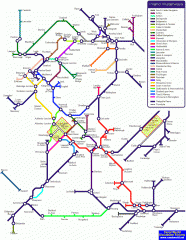
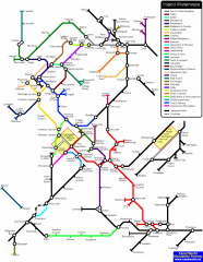
I popped in to have a look for this, and was surprised to see it discussed just a few months back. If anybody did want to continue to work on and improve the map, the editable png file is attached

-
I'm pleased that BT has decided to take this on further, and look forward to seeing it develop. I was working with just Paint.Net for the original so was limited in what I could do. I think you've rather missed the point of a schematic map; the intention is to keep to clear straight lines rather than represent geographical accuracy. And while that improvement could perhaps be made, the idea that the existing layout is "incorrect" is to mis-use the map in a sense.
-
I have adjusted the Rochdale, and have decided to offer you an alternatively coloured Fossdyke. I can't see much mileage in changing Stoke-on-Trent to Etruria though. It will only mean finding extra room to mention the city separately. Notably, the city took the name of Stoke partly because the town of Stoke-upon-Trent had the best connections, including the canal passing through it. http://img26.imageshack.us/img26/2890/full...analmapplus.png I also offer up a mere folly of the cruising rings in the same format: http://img6.imageshack.us/img6/9865/canalrings.png
-
A new version showing very rough outline sketches of areas in the BCN network and the fens. http://img12.imageshack.us/img12/2890/full...analmapplus.png
-
Duly corrected, thanks! This is something that has been troubling me. Do folks think it would look better/be more useful if the rough outline of the BCN network were shown in thinner lines, without labelling? It would still need looking at a larger scale map for any detail, but at least would show the elements of the connections? It would, though, run the risk of looking rather spaghetti-like within the coloured box. I shall give it a go and see how it looks. Tafkam
-
The latest edition: http://img27.imageshack.us/img27/4315/fullscalecanalmap.png
-
All changes I agree with, and will make!
-
The conclusion my own research had just led me to. Phew!
-
Oops! Yes, I'll correct that. Eek, yes! Another colour to find. I'll see what I can do! Has anyone managed to print out a large-scale version yet? How does it look?
-
Hopefully now complete: http://img6.imageshack.us/img6/4315/fullscalecanalmap.png And no updates for a while as we're off on a hire for a few days! By all means copy it and use it as you will - unless you're making money, in which case I want a cut Tafkam
-
The latest update: http://img32.imageshack.us/img32/7523/trial.png Hopefully including most advised changes, and all end-points and canal junctions. Now just to place intermediate towns, etc. and complete the key.
-
I've now finished what I think is the network outline at that larger scale. I haven't added any labelling as yet, nor all of the markers. I have changed from using the circular intersection symbol at all junctions, to using it only where there is an interchange between two 'different' canals. How do folk feel about this? I fear the original method showed rather a lot of black circles, but does this method leaves the junctions a little too unclear? http://img268.imageshack.us/img268/3779/trialg.png
-
I have quickly sketched out some basics of a much larger scale version - at around a3 size at 300dpi I hope. Is anyone who is likely to be able to print at that size able to check to see if the quality is good enough - rather than me complete the whole thing and not really get anywhere with it! I have uploaded it elsewhere as obviously the file size is considerably larger now: http://img29.imageshack.us/img29/7523/trial.png
-
Thanks for all the comments, folks! I've certainly no intention of making any money from it, but I'm happy to look at scaling up. Out of interest, what sort of resolution would people need for printing at A3 size? Would 300dpi for an image roughly 11½" x 15" work?
-
tafkam's files
-
-
From the album: tafkam
The PNG version -
Another update which hopefully incorporates all the suggestions - although I haven't marked out an extra stretch after Lechlade. We'll use RyanAir rules - it's vaguely in the vicinity of Lechlade, so we'll call it Lechlade I've also changed the use of colours so that hopefully almost every canal has its own colour now - it does mean lots of very close shades, but hopefully still differentiable. Any more errors? Or any new ones crept in?
-
Only because I consider the Mon & Brec to be a "real" canal - a point of contention I'd agree. I've included rivers and canalised rivers where they link with the main canal network, but not further afield. Maybe that's a point to be argued. I'm also reluctant to keep adding new colours! There are only so many shades of green that can be differentiated at that level!
-
Apologies for those struggling to see the latest view. I can only presume it is because I have just been overwriting the file each time. It is stored as an image in my user gallery. Here is the latest version - I await further corrections:
-
I think I might just have managed all of those alterations. I'm afraid I've no intention of differentiating between broad and narrow for two reasons. 1. It's trouble enough trying to find enough colours for different canals. Different patterns are incredibly difficult to include. 2. I only use narrowboats, so it's academic to me
-
Also duly corrected - thanks!
-
1. Done 2. Done 3. Why? The main stretch is parallel, but doesn't the current 'hump' better represent the geography? 4. Done As for restoration projects - fair point. I have removed the MK link for now. I might put all the various projects in, but I fear it may start making the whole thing look even more untidy at present. Would rather focus on the navigable routes first.
-
Constructive criticism is more than welcome! I'll hopefully address these few errors. Colours are becoming something of an issue though, hence there being a few shared routes with smaller navigations. Tafkam I've now made hopefully all of the changes suggested - more are always welcome - and have changed the format to gif to keep some clarity in the colour. It will mean that the old images have disappeared, but the current one is here: