R G Bargee
-
Posts
11 -
Joined
-
Last visited
Content Type
Profiles
Forums
Events
Gallery
Blogs
Store
Everything posted by R G Bargee
-

Three Fellows on the river Soar
R G Bargee replied to captain birdseye's topic in History & Heritage
I saw it! I do visit but haven't felt the need to comment, but I'll certainly follw up on this. Just read the message ... Ill be giving you my couple of years worth tomorrow hopefully. Anything specific let me know! RG -
Three Fellows on the river Soar
R G Bargee replied to captain birdseye's topic in History & Heritage
Also found this on "Starcross Blogspot"
-
Three Fellows on the river Soar
R G Bargee replied to captain birdseye's topic in History & Heritage
I honestly don't remember there being geese there then! I've seen them when I've returned there since. I DID once lassoo a Nun who was inconveniently sat on a bollard though!! -
Three Fellows on the river Soar
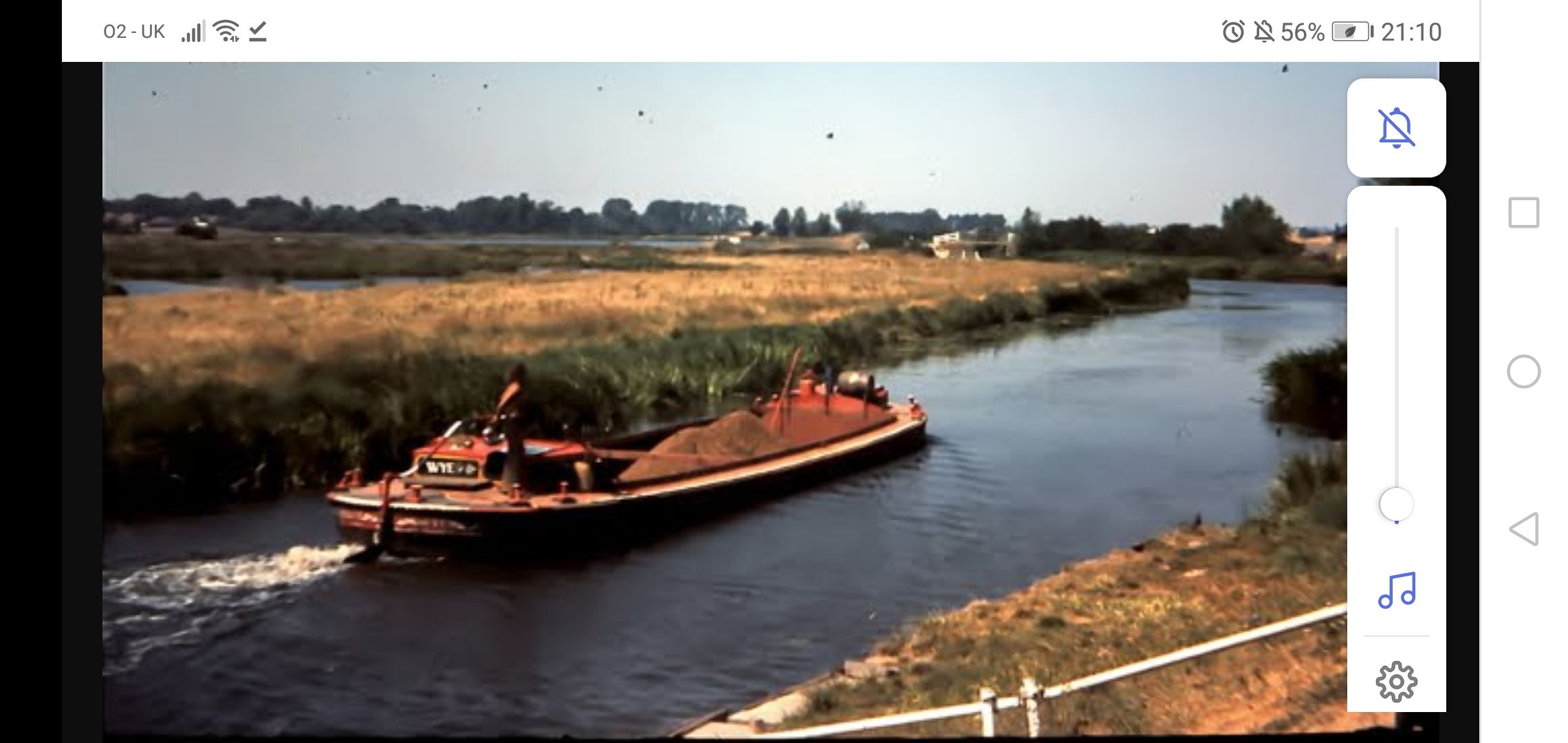
R G Bargee replied to captain birdseye's topic in History & Heritage
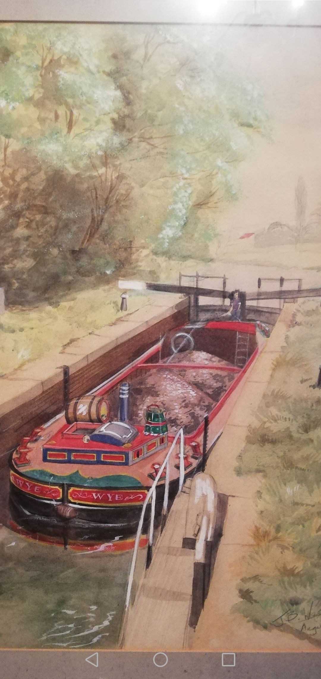
As promised. "WYE", loaded, in Thurmaston Lock, 1975. Yours truly on the tiller!!! A watercolour painting done for me by John West.
-
Three Fellows on the river Soar
R G Bargee replied to captain birdseye's topic in History & Heritage
Just for the record. Boat on the left if "Shirley" of 3 Fellows carrying, steered by Ralph Mould, who lived in a houseboat by Thurmaston Lock. Boat on right is June, steered by Joe Walker, who was ex-Willow Wren, and who had previously been on the Liverpool--BOCM Manchester grain traffic with WYE and BURSCOUGH 2. -
Three Fellows on the river Soar
R G Bargee replied to captain birdseye's topic in History & Heritage
Definitely Mould. Myself and my partner at the time spent hours with him and his lovely Wife. Just sitting on the bank of the backwater and discussing literallty, life, the Universe and everything! Great times -
Three Fellows on the river Soar
R G Bargee replied to captain birdseye's topic in History & Heritage
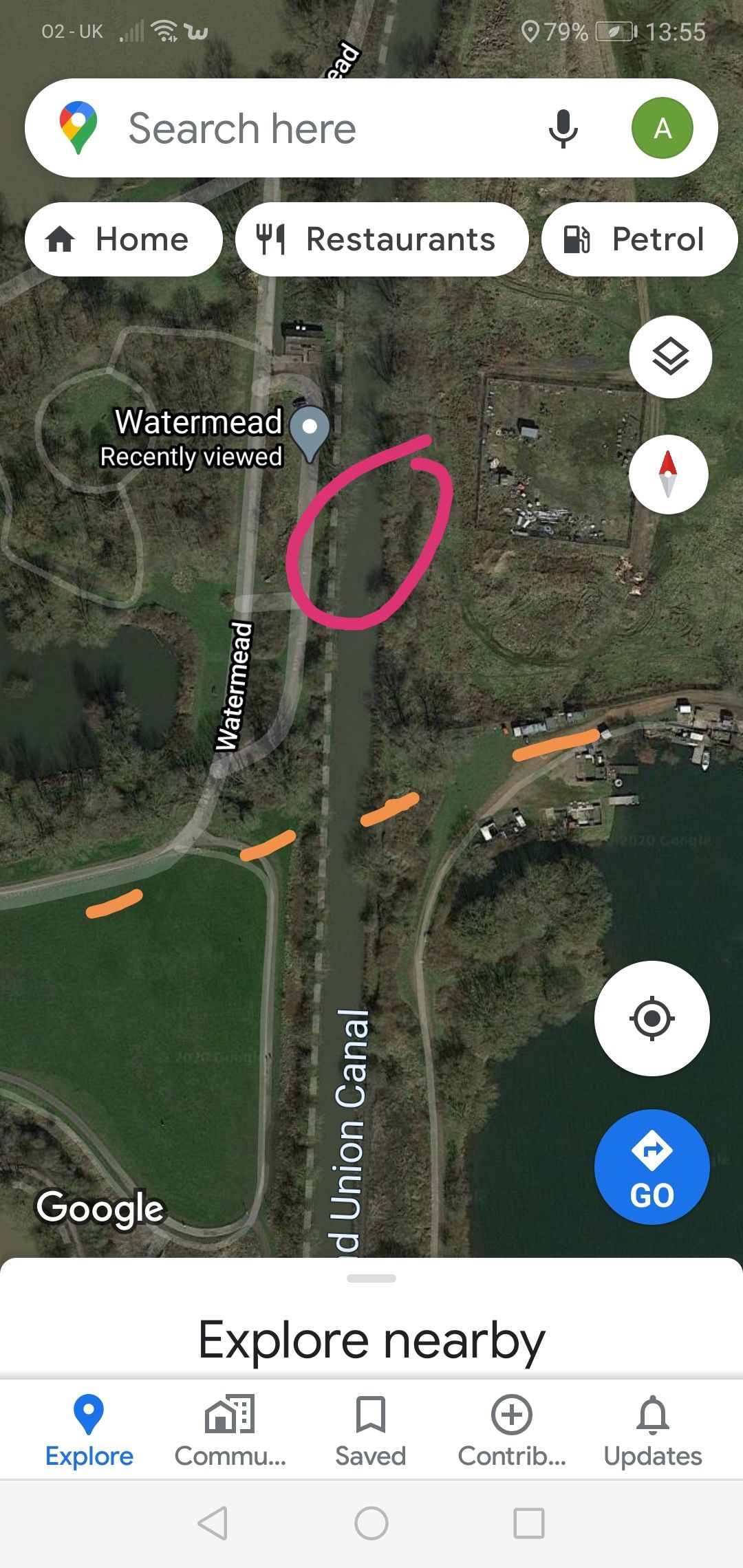
Just had a browse on GE, and got a better idea... Orange line is where i THINK the track/bridge was. Circle is showimg a wider area, maybe winding hole. Thinking back again, the bridge in question might not have been a brick built structure, but maybe a Bailey type temporary one, to allow the gravel trucks to cross.
-
Three Fellows on the river Soar
R G Bargee replied to captain birdseye's topic in History & Heritage
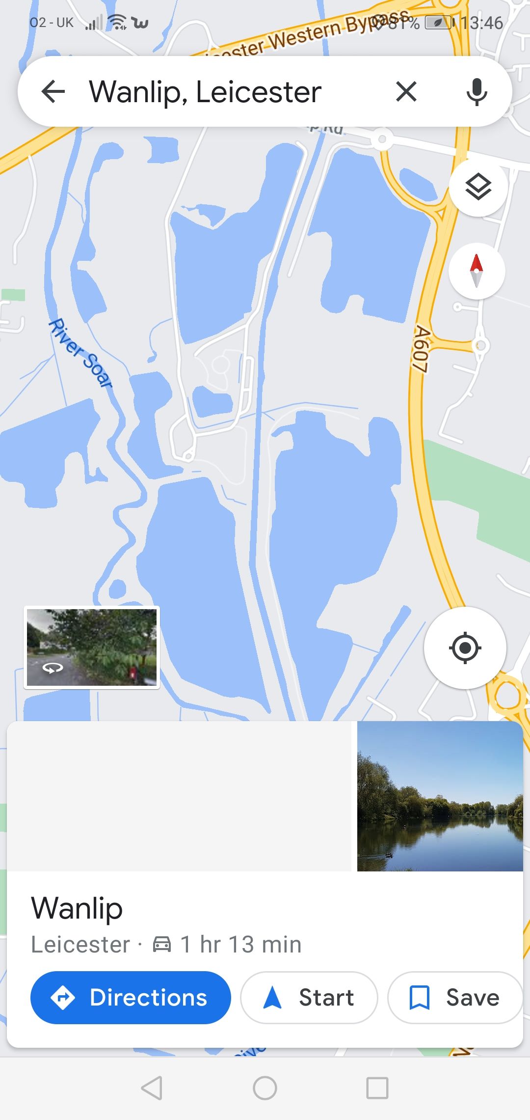
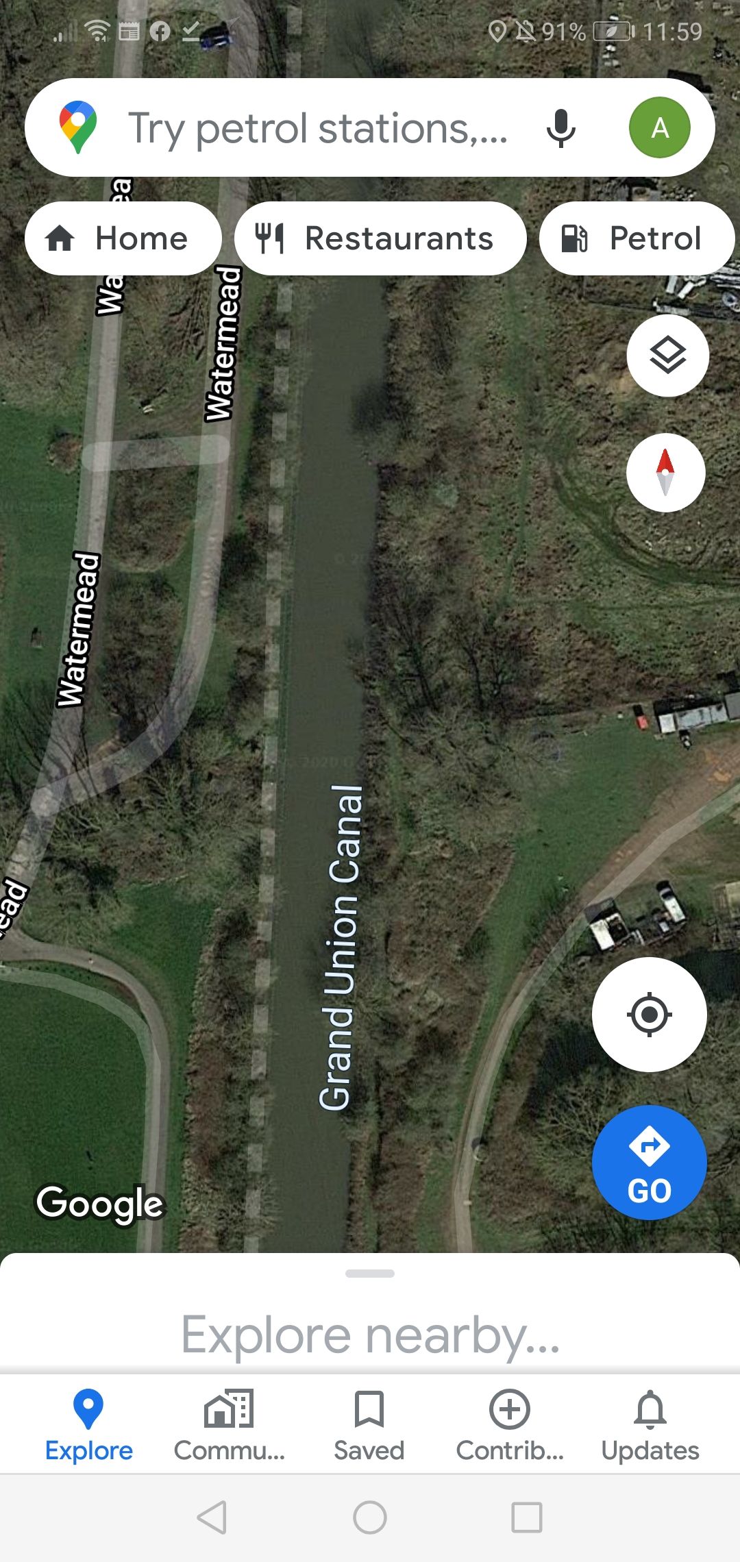
No. Not Wanlip Road, that looks to be too far North. I suspect the bridhe in question has been demolished. It would have been where Watermead swings North to run parallel to the cut I'm almost certain. A wider map enclosed. The track would have been where the stream is now shown I think.
-
Three Fellows on the river Soar
R G Bargee replied to captain birdseye's topic in History & Heritage
A difficult one, as a) it was 45 years ago, and b) the area has changed so much! Looking on GE, I estimate it to be where Watermead swings round. If you project Watermead east, there is a track on the East bank which I'm sure used to cross a brick built bridge, and the unloading point was on the East bank, just North of this bridge. An old Nicholsons or similar would pinpoint the bridge more accurately. The unloading point was just a low piled wharf, and a 360 was used with a grab. Initially, we used to wind about 2-300 yards before the bridge and reverse down, through the bridge, but it was a complete PITA, and the 360 was utilised to dig out a winding hole just North of the wharf. GE shows no trace of this now, but it is incidentally where the 2 "oversized" boats were. They must have been there when I was, but I can't honestly say for certain. I know they were there in 1973 when I took "Chertsey" up there on a holiday trip. Next time I take a tacho break in the area, I will try and nip down for a look!
-
Three Fellows on the river Soar
R G Bargee replied to captain birdseye's topic in History & Heritage
Wow! Takes me back... Same hairdo! -
Three Fellows on the river Soar
R G Bargee replied to captain birdseye's topic in History & Heritage
Just found this thread, and joined canalworld! I worked on the Soar job at its inception, and continued for most of the long hot summer. The biggest problem was the mechanical unloading... Despite having an absolutely superb 360 driver, (Alan???), the shuts were in a terrible state pretty quickly. This led to gravel getting packed solidly into the bilges, and on more than one occasion, a sharp corner puncturing the hull. A time of my life I wouldn't have missed for anything, despite the relentless work and less than ideal conditions. "Shirley" was steered by a wonderful bloke called Ralph (Mould/Moulds???), who had worked pairs for a fair proportion of his life, and who lived on a houseboat down the backwater at Thurmaston Lock. "Whitby" was steered by a hilarious character, Barry from Brum, who's humour and friendship were much appreciated. I often stop in the area if delivering nearby, and walk down Mill Lane for a reminiscing session on the lock bridge. Ive got a painting somewhere of WYE in Thurmaston lock, which John West did for me a couple of years later... I'll post it if I dig it out with the xmas deccies!