Chris Lowe
Moderator-
Posts
2,057 -
Joined
-
Last visited
Content Type
Profiles
Forums
Events
Gallery
Blogs
Store
Everything posted by Chris Lowe
-

Google Earth Canal & River Map. (Canalmaponline)
Chris Lowe replied to Chris Lowe's topic in History & Heritage
I'll be updating this soon, I had a bit of a rest from doing it. The main update will be the Oxford canal, but also a Viking canal. -
Google Earth Canal & River Map. (Canalmaponline)
Chris Lowe replied to Chris Lowe's topic in History & Heritage
Can we bring this thread back on topic with regards feedback on my map, although the tramway map is very relevant thanks. But does anyone have info about the Gayton to Northampton tramway? chris -
Google Earth Canal & River Map. (Canalmaponline)
Chris Lowe replied to Chris Lowe's topic in History & Heritage
Blisworth Hill Tramway updated. -
Google Earth Canal & River Map. (Canalmaponline)
Chris Lowe replied to Chris Lowe's topic in History & Heritage
Down to claydon top lock on the oxford canal so hopefully i'll have it done for next weekend & will be able to upload the locks & bridges & update northern loops. -
Google Earth Canal & River Map. (Canalmaponline)
Chris Lowe replied to Chris Lowe's topic in History & Heritage
Thanks Kathryn It looks like it pretty much follows what became the tow path -
Google Earth Canal & River Map. (Canalmaponline)
Chris Lowe replied to Chris Lowe's topic in History & Heritage
Normal feedback process is via the contact us button on the website, but I'm making notes of comments here as well. Kathryn Do you have a map showing the full extent of the tramway, what i have i got from the Blisworth village website. The other tramway I'm trying to trace in that area is the Gayton to northampton tramway. Chris -
Google Earth Canal & River Map. (Canalmaponline)
Chris Lowe replied to Chris Lowe's topic in History & Heritage
I've made a not of all he suggestions in my todo list so they'll all get added eventually. Chris -
Google Earth Canal & River Map. (Canalmaponline)
Chris Lowe replied to Chris Lowe's topic in History & Heritage
I've done the Dartford Creek but it won't appear on the map until i do my next upload. Dartford Creek i have stopped where 2 weirs are shown on the 1894 25inch OS map & its where the light railway now crosses. Chris -
Google Earth Canal & River Map. (Canalmaponline)
Chris Lowe replied to Chris Lowe's topic in History & Heritage
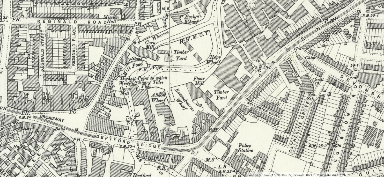
Think I can answer my own question as it looks like it was navigable to just below Deptford bridge as there are no wharfs past that point.
-
Google Earth Canal & River Map. (Canalmaponline)
Chris Lowe replied to Chris Lowe's topic in History & Heritage
Thanks Scholar Gypsy I'll check limehouse basin, I think I did show the now filled in original cut it's a bit messy around there so I may have to change some colours. I'll also add Deptford Creek, how far is it navigable? Chris -
Google Earth Canal & River Map. (Canalmaponline)
Chris Lowe replied to Chris Lowe's topic in History & Heritage
Done a minor update to the Oxford canal and the old Arbury canals, major Oxford canal update soon. -
Plane Under Pontcysyllte Aqueduct?
Chris Lowe replied to cheshire~rose's topic in History & Heritage
In the 80's the guys in the boatyard at Trevor told me that the AWACS from RAF Valley would sometimes fly low down the valley and over the aqueduct. The wingspan of hawk trainers flown from valley is 9.39m. -
Google Earth Canal & River Map. (Canalmaponline)
Chris Lowe replied to Chris Lowe's topic in History & Heritage
Thanks it has taken a long time and for some of the long gone obscure canals a lot of research as well. It isn't supposed to be a navigation map as I've included disused and long destroyed waterways, and others have the navigation side of things well covered. You'll find that Ireland is complete for locks, bridges and other features, Brian at https://irishwaterwayshistory.com helped with this and for the UK I've done: River Thames Grand Union Canal Kennet & Avon Canal Somerset Coal Canal Wilts & Berks Canal Thames & Severn Canal Bridgewater & Taunton Canal Itchen Navigation Portsmouth & Arundel Canal Wey & Arun Canal (This one has even more detail as I'm a trust member) Baybridge Canal Sussex Ouse Navigation River Medway River Stour (Kent) River Wey Basingstoke Canal Monkland Canal Currently doing the Oxford canal from Hawksbury junction down. Chris -
I have created a large Google Earth file mapping all the canal & river navigations that i have so far been able to find, I can make the base GE file available but it can be viewed on-line here: http://www.railmaponline.com/Canals.php if anyone spots any omissions or errors please let me know. Not all the navigations have all the locks and bridges marked yet I'm gradually working my way through doing these, the Oxford canal is currently being done. Chris