Tony Brooks Posted June 3, 2023 Report Share Posted June 3, 2023 It looks more river than canal so, although I have never been there, I get the feeling of Middle Levels, possibly around Upwell. Link to comment Share on other sites More sharing options...
oboat Posted June 3, 2023 Report Share Posted June 3, 2023 (edited) Right county wrong navigation. Two boats just below the first Br. Edited June 3, 2023 by oboat Link to comment Share on other sites More sharing options...
Captain Pegg Posted June 3, 2023 Report Share Posted June 3, 2023 My first thoughts were March but that's just from other photos as I've never been there by water. Link to comment Share on other sites More sharing options...
oboat Posted June 3, 2023 Report Share Posted June 3, 2023 1 hour ago, Tony Brooks said: It looks more river than canal so, although I have never been there, I get the feeling of Middle Levels, possibly around Upwell. Not the Middle level in fact it requires a tidal transit. Link to comment Share on other sites More sharing options...
magnetman Posted June 3, 2023 Report Share Posted June 3, 2023 It looks tidal in the last picture. We did GU to Peterborough, St Neots and Cambridge and back about 22 yars ago can't remember that much of it. Also the only tidal bit we did was Salters lode to Denver sluice. I remember Salters as one of the fillings I had as a kid broke in half while eating a steak. Ouch ! Link to comment Share on other sites More sharing options...
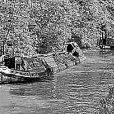
oboat Posted June 3, 2023 Report Share Posted June 3, 2023 (edited) 59 minutes ago, magnetman said: It looks tidal in the last picture. We did GU to Peterborough, St Neots and Cambridge and back about 22 yars ago can't remember that much of it. Also the only tidal bit we did was Salters lode to Denver sluice. I remember Salters as one of the fillings I had as a kid broke in half while eating a steak. Ouch ! Try the middle ground.This lot should make it easy. WW reporter on the lock side. Edited June 3, 2023 by oboat Link to comment Share on other sites More sharing options...
David Mack Posted June 4, 2023 Report Share Posted June 4, 2023 (edited) This canal ceased to be used the best part of 200 years ago, but is still in water. Further along, this house has been built on the canal line where it crossed an ancient road. Opposite the house, these gates lead to the site of a wharf where the truncated canal ended for some time. But that truncated section subsequently became disused and is now mostly shallow water and reeds. 100 yards or so from where this length meets navigable water there is a bridge - no parapets but the arch is still in place and still used by livestock. Where am I? Edited June 4, 2023 by David Mack 1 Link to comment Share on other sites More sharing options...
John Brightley Posted June 4, 2023 Report Share Posted June 4, 2023 7 minutes ago, David Mack said: This canal ceased to be used the best part of 200 years ago, but is still in water. I know the answer but I have the unfair advantage of local knowledge so I'm not going to say ! Nice set of photos David. Link to comment Share on other sites More sharing options...
Heartland Posted June 5, 2023 Author Report Share Posted June 5, 2023 Yes very useful, I have taken RCHS parties to this location in the past, if I recall recall correctly the spot. Link to comment Share on other sites More sharing options...
davidg Posted June 5, 2023 Report Share Posted June 5, 2023 And the canal crossed the road three times in half a mile. Link to comment Share on other sites More sharing options...
Neil TNC Posted June 5, 2023 Report Share Posted June 5, 2023 On 03/06/2023 at 12:18, oboat said: Try the middle ground.This lot should make it easy. WW reporter on the lock side. Fulney Lock, tidal entrance to River Wellsnd. That's the lock EA seem to be incapable of using as a lock, you always have to go through on a level, in our case a falling level. The EA staff seem to be more worried about it failing on a incoming tide....or are they more worried about the fishermen? 😀 Link to comment Share on other sites More sharing options...
Captain Pegg Posted June 5, 2023 Report Share Posted June 5, 2023 21 hours ago, David Mack said: This canal ceased to be used the best part of 200 years ago, but is still in water. Further along, this house has been built on the canal line where it crossed an ancient road. Opposite the house, these gates lead to the site of a wharf where the truncated canal ended for some time. But that truncated section subsequently became disused and is now mostly shallow water and reeds. 100 yards or so from where this length meets navigable water there is a bridge - no parapets but the arch is still in place and still used by livestock. Where am I? One of the by-passed sections of the north Oxford? Fits with the 200 years. Brownsover? Link to comment Share on other sites More sharing options...
Neil TNC Posted June 5, 2023 Report Share Posted June 5, 2023 Link to comment Share on other sites More sharing options...
David Mack Posted June 5, 2023 Report Share Posted June 5, 2023 31 minutes ago, Captain Pegg said: One of the by-passed sections of the north Oxford? Fits with the 200 years. Brownsover? Close... Link to comment Share on other sites More sharing options...
Captain Pegg Posted June 5, 2023 Report Share Posted June 5, 2023 20 minutes ago, David Mack said: Close... Newbold. I’ll get it eventually! Link to comment Share on other sites More sharing options...
Graham_Robinson Posted June 5, 2023 Report Share Posted June 5, 2023 You're in Brinklow. Link to comment Share on other sites More sharing options...
Captain Pegg Posted June 5, 2023 Report Share Posted June 5, 2023 15 minutes ago, Graham_Robinson said: You're in Brinklow. Spoilsport 😀 That was obviously my next guess. Link to comment Share on other sites More sharing options...
Graham_Robinson Posted June 5, 2023 Report Share Posted June 5, 2023 (edited) 17 minutes ago, Captain Pegg said: Spoilsport 😀 That was obviously my next guess. You trying every arm on the North Oxford? 😄 Edited June 5, 2023 by Graham_Robinson Link to comment Share on other sites More sharing options...
David Mack Posted June 5, 2023 Report Share Posted June 5, 2023 29 minutes ago, Graham_Robinson said: You're in Brinklow. Yup. The straightening of the North Oxford removed a huge loop from around Brinklow, as shown on this map of the old and new lines (from the Rose Narrowboats website). The Western part of the loop, as far as the Fosse Way was retained as an arm to serve Brinklow village, and this section is now a very silted up, but still intact. I don't know when it became disused. Most of the rest of the loop has largely disappeared, although you can still follow some of it on Google earth. There is a section west of Rugby Road which is still in water. These extracts are from the NLS 1:2500 map. The first shows the Brinklow Arm and the second shows the section west of Rugby Road in water, as well as the route west of there through to the southernmost of the 3 crossings of the main road which @davidgreferred to earlier. Link to comment Share on other sites More sharing options...
Graham_Robinson Posted June 5, 2023 Report Share Posted June 5, 2023 (edited) Pity that map from via Rose wasn't a higher res. And here's a pic. of Stretton Wharf courtesy of Rose Narrowboats. You could try exploring that loop. Edited June 5, 2023 by Graham_Robinson Link to comment Share on other sites More sharing options...
David Mack Posted June 5, 2023 Report Share Posted June 5, 2023 2 minutes ago, Graham_Robinson said: Pity that map from via Rose wasn't a higher res. Indeed, but it is good enough to pick out the original route on Google earth aerials. Link to comment Share on other sites More sharing options...
Chris Lowe Posted June 5, 2023 Report Share Posted June 5, 2023 A bit like this David? Link to comment Share on other sites More sharing options...
Graham_Robinson Posted June 5, 2023 Report Share Posted June 5, 2023 Talk about round the houses.. Link to comment Share on other sites More sharing options...
Chris Lowe Posted June 5, 2023 Report Share Posted June 5, 2023 2 minutes ago, Graham_Robinson said: Talk about round the houses.. Makes for some challenging steering Link to comment Share on other sites More sharing options...
David Mack Posted June 5, 2023 Report Share Posted June 5, 2023 11 minutes ago, Graham_Robinson said: Pity that map from via Rose wasn't a higher res. And here's a pic. of Stretton Wharf courtesy of Rose Narrowboats. You could try exploring that loop. I am sitting on Belfast moored right there at this moment! Link to comment Share on other sites More sharing options...

Featured Posts
Create an account or sign in to comment
You need to be a member in order to leave a comment
Create an account
Sign up for a new account in our community. It's easy!
Register a new accountSign in
Already have an account? Sign in here.
Sign In Now