stort_mark
-
Posts
650 -
Joined
-
Last visited
Recent Profile Visitors
5,577 profile views


stort_mark's Achievements
")
Proficient (7/12)
25
Reputation
-
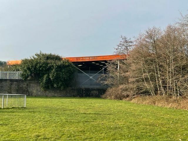
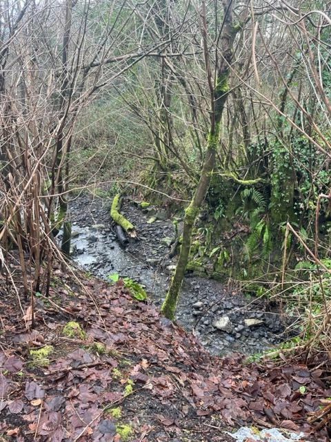
The second part of my investigations last week. I had a little time to look at Smith's Canal at the lower end, down at Foxhole and the White Rock Copperworks. As always is the case, being on your own exploring around these kinds of areas with heavy undergrowth and uneven ground poses significant risks (especially with ice on the ground), so I was unable to do as much as I wished. This is a fairly well-known view of Smith's Canal as it enters a tunnel under the White Rock Copperworks. I'm not sure why there are two entrances here at the northern end (there appears to be only one exit at the other end) but there is quite a lot of spoil all around and it is possible parts have been covered over. I still have a lot of documentation to read about both the White Rock works, so this may all be explained somewhere. Looking back north from above the tunnel entrance. It is intriguing that the wider area at the far end in the photo appears to be the only wider place where boats could wind. From the tunnel approach to the coal staithes on the river (through the tunnel and along the river bank for some hundreds of metres) there is simply no space for a winding hole. I did wonder if these horse-drawn boats (do any exist now?) were perhaps double-ended. However, there is no doubt that there has been slumping of the uphill slope and it is possible that any winding hole was simply filled in later, as space is at a real premium here. the photos don't show how steep the slope is either side of the canal bed, and they also managed to squeeze many narrow buildings in too. This is the southern end of the tunnel, with a rather curious wall arrangement above the tunnel entrance. It was incredibly difficult to move around this area and I wasn't able to explore the last few hundred meters to the remnants of the coal staithes on the river. The canal 'bed' is currently at 14m here, the same as at Llansamlet Church. So there were no need for locks. However, the last 0.75km from the accepted end at Llansamlet and the probable end does see a rise of about 4m suggesting there may have been two or more locks at the very beginning of the canal. Even today there is a strong flow of water from a spring near Scott's Pit so this could have been a source of water for that very short pound. This is included only to show the very beautiful stone work that is still there. It looks like the retaining wall height was increased at some stage, but using thinner, flatter stones. One of the most interesting features was the use of openings in the side wall of the tunnel to allow coal to be unloaded almost directly into furnaces and smelters. There are four of these openings. Until recently these were completely accessible, but sadly security fencing has been put up to prevent people like me coming to harm on icy January mornings. Security fencing and remains of part of the old White Rock copperworks. For anyone interested in this canal and the industrial history of this area - once described as the most desolate, derelict and polluted landscape in Europe - there is a good selection of references. The early OS maps are great (NLS Library) but also the usual selection of specialist maps, the listed buildings are archaeo sites, etc. Next stop will be the National Archives. Obviously the Hadfield book. Some books - notably D. Morgan Rees "Industrial Archaeology of Wales" - are surprisingly unhelpful though. "Swansea Copper", Chris Evans and Louise Miskell "Copperopolis: Landscapes of the Early Industrial Period in Swansea" "The Smelting of Copper in the Swansea District of South Wales: From the Time of Elizabeth to the Present Day", George Grant Francis "The Lower Swansea Valley Project", ed. K.J. Hilton. One of the chapter authors of the last book filmed their regeneration work in 1962 and has included not only the original footage on YouTube but also three other versions that show the same scenes in 2012 and also plot the exact filming locations. Although there is nothing of Smith's Canal, it does illustrate the scale and nature of what lay in the Lower Swansea Valley and it is easy to compare this with what is there now. The house on the left of the bend at 0:36 in the video is now this house on Jersey Road in Swansea. I'm quite interested in exploring more but would need like-minded people to do it, for safety reasons.

-
The Welsh tithe maps are extremely interesting and I have been using them to track down something even more remote than the Pen Clawdd Canal. They don't add much to the story of the upper Smith's Canal though. Funnily enough, the canals around the Loughor estuary are already on my radar, as I spent last Wednesday trying to get access to parts of the Kymer's Canal network around Kidwelly and Burry Port. Easier said than done, as with all the canals in this area.
-
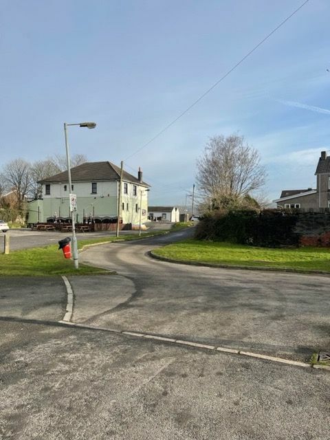
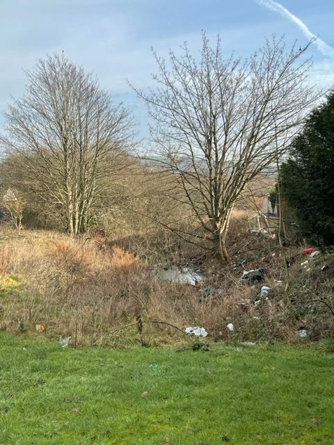
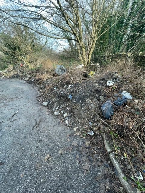
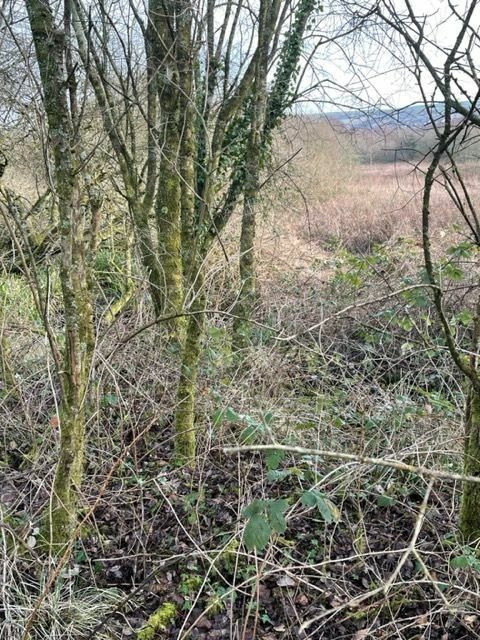
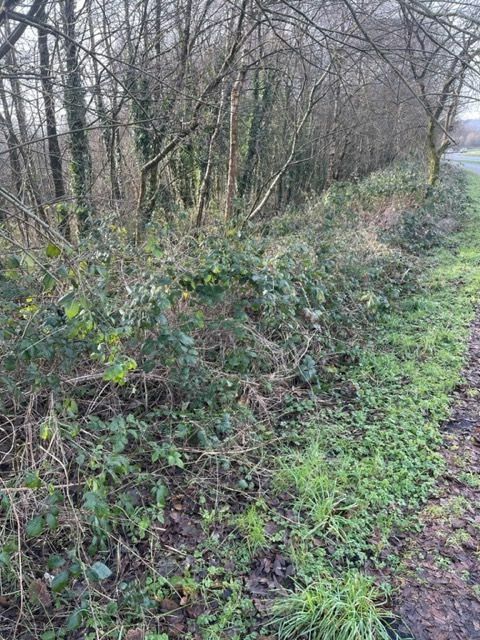
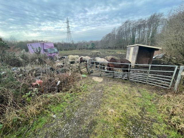
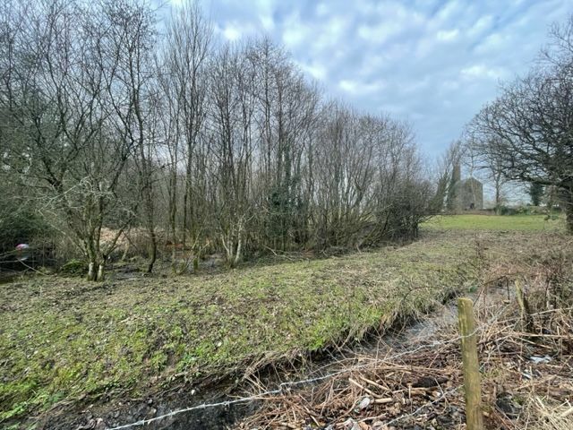
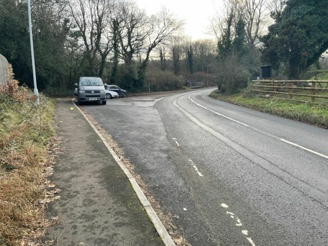
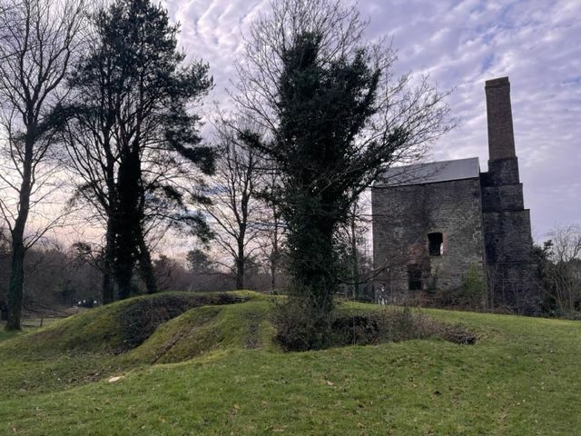
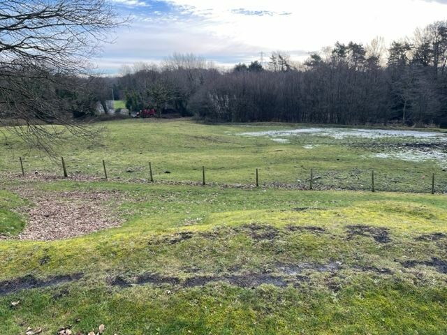
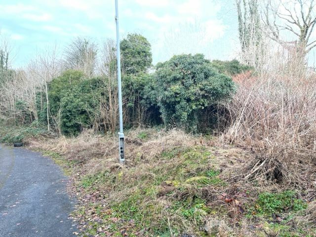
More on Smith's Canal I decided I wanted to know more about this remote canal, so travelled to Swansea last week to see what more could be found. The reality is that even where there should be remnants - because the canal hasn't been built over - it is remarkably difficult to get to the original line of the canal. From Llansamlet church eastwards to the starting point, the canal should be accessible and as it's the absolute middle of winter, there is minimum vegetation. But still it's almost impossible to quickly or easily access the line of the canal. This is the Plough and Harrow pub, and looking east. The canal ran towards me along the tarmac (which is now the entrance to the Llansamlet Community Centre). The pub car park is to the left. There is a b&w photo of this scene and is the only photo I have seen of the canal fully in water, although without any boats. This is now looking west from the south side of the community centre. The canal ran alongside the rough grass and the lower brick wall at the end is where the canal continued. Most of the next mile is covered by the Swansea Enterprise Park. On the other side of Church Road in Llansamlet, looking east. I had hoped to walk this stretch towards the start of the canal. But it just wasn't possible. The fly-tipped rubbish is obvious. The land beyond doesn't seem to be used but access is tricky as there are few public footpaths. It's not even clear who owns the land. I'm not overly bothered about trespassing as long as I'm not damaging crops, fences, assets, etc. But physically it wasn't possible. The water can be seen here. This is the route of a public bridleway (not just a footpath!) from the end of Tawe Road (off Peniel Green Road) and it goes north towards the new B4625. Completely impassable and no sign of a path. The wall on the right is the wall of the former Swansea Vale Railway. Long gone. Getting to the canal from the north - the B4625 - is a lot easier although the path is obviously little used. The fly-tipping at the southern end might have something to do with it. The canal line is straight ahead along the line of the young trees, with marsh to the right, and this is heading NE. Ive learnt that on many disused canals, the trees tend to grow out of the former canal bed rather than the bank or the former towpath. The canal crosses the B4625 here but no trace on either side beyond some small ridges. The canal was crossed by the Swansea Vale Railway. However, as the canal was closed in 1852, I'm not even sure if there was a bridge over the canal. This is a field between the old railway embankment and the M4 embankment off to the right. In early 6" OS maps, there is clearly a line of marsh and even 'canal width' open water across this field, with the latter more or less where these ponies are standing. The start of the canal was the Gwernllwynchwyth estate and the pits around it. The most likely end point (ignoring what Coflein record as they are clearly wrong) was Scott's Pit, seen here. The old engine house remains and can be seen on a rise in the middle right of the photo. The canal almost definitely ended in this copse in the field. It is possible that the canal continued just beyond the barbed wire at the lower edge of the photo. However, this seems to be on a slight rise whereas the copse is flat. This is the road and parking opposite the Scott's Pit site (to the right). However, this odd road shape shape has been here since the earliest OS maps and must surely have something to do with the canal and/or local waggonways. The engine house at Scott's Pit. There has been little excavations done to date. The field to the immediate south of Scott's Pit with the copse beyond the frost on the far side of the field. The photo of the copse above was taken from the gap in the trees on the upper left. An additional twist to this story is the Gwernllwynchwyth (try saying that to a taxi driver after a few pints) which is now completely ruined and overgrown with absolutely no attempt to even make it safe let alone any form of interpretation. The estate was the focal point of the coal estate, with pits scattered around. Smith's Canal (Smith bought the estate early on) was replaced and it is likely that the upper 0.75km was closed early on and a waggonway ran from the pits around Gwernllwynchwyth for about 500m to a 'new' terminal basin. As a final treat (I will do an update on the Hafod-Morfa end of the canal in due course) this is part of an artificial water supply system known as Chauncey's Great Leat that supplied water from streams in the Gwernllwynchwyth estate to coal mines and early industry in Pentrechwyth several miles to the southwest, close to the Tawe. This arrangement doesn't make total sense because one immediately asks the question why not get water from the Nant y Fendrod or even the Tawe itself. Bricks and stone linings can be seen in the watercourse, but - as everywhere with this long-lost canal - it's so difficult to access. There is no connection possible between Smith's Canal and the Swansea Canal. The former is on the eastern side of the Tawe, the latter alongside-ish on the western side.
-
Little bit of an update on this as I am writing a book and out of the blue, that activity intersected with canal history. Recent weeks of research have revealed such fascinating canals as the Neath (and various navigation predecessors), Tennant's, Glan-y-Wern (and I haven't even got to the Swansea Canal yet). I had never even heard of Smith's Canal until the last few days, but it now has me hooked. It is interesting that the Coflein information is suspect, especially at the northern end, probably because this canal closed so early and there is **almost** no trace remaining of the canal. Parts of the route were then obliterated by a tramway replacement and then the Swansea Vale Railway. So it looks to me as if RCAHMW and GGAT input has focussed on the southern end around the tunnel and the coal staithes at Foxhole, but up toward Llansamlet the information has largely been seemingly pulled from early OS maps - and not very effectively. Hadfield writes barely four paragraphs about the canal, and most of that is quoting from a single thesis about the development of Swansea and a history of Swansea Docks, so seemingly very little has been recorded about it. To be fair, there's really not a lot written or recorded about the early Neath estuary canals either. The canal is stated as having started "near Gwernllwynwith House", the estate of the eponymous John Smith. Hadfield then mentions the canal being paralleled by a tramway to a nearby pit - Scott's Pit - half a kilometre north on the road to the village of Heol Las. Yet RCAHMW state that the end of the canal is at grid ref SS 69365 97890. This is undoubtedly because this is the end of a watered section. From this point it is clear that a tramway ran straight as an arrow across several fields to the pit at Gwernllwynwith, and that tramway ran across the end of the canal and ended on the north side of the cut. However, even a cursory glance at the same map shows marshy ground - as wide as the watered section and continuing on the same line. Indeed, on another map, this marshy stretch is even marked 'Old Canal'. It seems likely that this marshy length was closed before the part still then in water because otherwise the tramway would more likely to have been terminated on the south side of the cut, rather than the north side. 18th Century Welsh pit owners weren't renowned for their habit of spending money unnecessarily. So where did this older cut go? Well it seems to have reached only another 0.73km further than the RCAHMW-stated endpoint at SS 69720 98365, at the northeastern corner of Scott' Pit. As well as the marshy strip, these early maps show two additional rectangular 'canal-width' water-filled hollows, one now hard up against the M4 embankment where the Peniel Green - Heol Las road passes under the motorway and another just to the west of that minor road just beyond the motorway. These depressions have now vanished but the first one is marked on several subsequent maps. It is possible that the second depression was the actual terminal basin as the map shows a curious change in the size of the adjacent road at this point. There is reference to the wharf at Birchgrove yet there is no sign of the canal extending to that village. Scott's Pit is as close at it gets. Between Scott's Pit and the village (and more pits) is Birchgrove House, so possible that the landowner didn't want a canal crossing his land - purse speculation that. On LIDAR there are faint traces of the canal but it's the maps that are the real clues. I am aware of the presece of Townsend's Great Leats but these are several hundred metres to the south at their closest. However, it possible that the canal was built over the functioning leat, as the leat is known to have served the Pwll-Mwr colliery (close by the junction of the GWR and the SVR at Winsh-wen). Despite frequent reference to the canal closing in 1852, it's really not known when it closed and it is possible parts of the canal remained open considerably later, if only to bring coal the short distance from pits to the multitude of works that covered the Lower Tawe Valley. Looking at the local maps, it would seem that there were tramways coming in from other local pits (one of them even marked as Smith's Road - although obviously Smith is a common name). Listing of specific records of interest Smiths Canal - overall reference Coal staithes at Foxhole (Southern Terminus) White Rock Tunnel (under White Rock Copperworks) [The Copperworks record includes a map of the site that includes the canal and location of the side openings] Canal Bridge, Llansamlet Village (Now demolished. Was by Plough & Harrow Pub. Newer tarmac shows exact location) Smith Canal [sic] GGAT Record
-
The city of Cardiff has spent much of the last 50 years trying to eradicate all traces of its former canals, but it seems times are achangin'. However, not sure the Bute East feeder canal was really part of the canal, was it? The Glamorgan Canal ran some 100m west through what is now the St David Centre before curving around onto Mill Lane and past the Customs House. https://www.walesonline.co.uk/news/exposed-light-day-first-time-24955531
-
I finally decided that there were enough unusual and improbable home locations that I decided to press ahead with painting 'Stranraer' below the name 'Cypress' as a tribute to my late father's hometown. Given the move of the ferries to Cairnryan in 2011, I think NB Cypress is now the third-biggest vessel registered in Stranraer after two 110,000GRT Stena LNG tankers. Mine is the only one that can get round Sutton Stop in one swing.
-
NB Cypress has been restored to life. Thank you to all for your extremely valuable help. I decided to call RCR who were extremely helpful and after co-ordinating no less than five parties (me, RCR centre, RCR engineer, person with key to the boat, person with key to the wharf), all the planets lined up Friday morning: a new Numax XV31MF with freshly baked cranking power ("You could restart Chernobyl with that"), carefully timed button pushing and a swing of the lever and she started up. So it was goodbye to the friendly folk at Swan Lane Wharf and we then floated off to Hinckley, stopping after three minutes to retrieve a builder's rubble bag that wound itself around the prop. The very last bridge (#17) removed the 'splitter' on the exhaust (sure there's a technical term) but a lovely days' cruise. If I hadn't been a bit pressed for time, I'd have gone down to the basin, one of my favourite places on the network. As always when entering a strange marina for the first time, there was a huge socially-distanced audience and the still air turned into a gale force northerly, and I successfully demonstrated my party trick of manoeuvring a boat backwards and forwards to no effect. The only negative part of the day was the "That's some tickover" comment from the sour-faced canal guru at Bridge 5, who was barely tied up at the visitor mooring. The 3VRH has quite a fast note, and because Cypress swims so quickly (with no wake, no wash), I usually give her a burst of reverse and then take it out of gear when going past moored boats but that does - for a short time - increase the engine speed. I was so stunned by his sarcasm, all I could do was turn to look at my zero wash and wake, and ripple of a bow wave and shake my head. But at least I had a further hour to think up witty and cutting retorts. But again, thank you all for your helpful advice and commentary. We don't know the exact cause of the problem, but plan to do a bit more diagnostics.
-
Hi Mike, I was going to get an email put together for you and Jim, mainly to show the fabulous paint job Chris has done. But this has rather taken over this week! The engine was started fine on Saturday and ran for a couple of hours, but failed to start on Sunday morning. The whole job (from picking up at Cowroast to getting up to Stretton Stop, painting and this) happened while I was in Ethiopia so everything had to be explained from a distance and I know they had a good chat with Darren before leaving. I think they've started the engine many times with no problem so it's been a surprise for all of us a bit. I'm going to put a new battery in Friday and see whether it's as simple as that (I suspect not). There's been some good suggestions here, but I'm having to work from memory and photographs. Thanks, Mark
-
It hadn't been run for more than a month I think. (I can't be sure - I work overseas) We will check the alternator.
-
I am trying to get more information but I appreciate the input so far. I am 80 miles away stuck in a hotel and relying on third parties. There's a sense that this might be as simple as the battery expending so much effort yesterday that two hours running wasn't enough to put much charge back in the battery. The this morning, the first few failed cranks used up the last of the power. I was told the engine was turning over but not firing, with a feeling that the engine wasn't turning quite fast enough to fire. Then with the jump batteries, the long jump leads were too long and not thick enough and so there was heat build up. I'm going to get an engineer to have a look in the next few days and probably get a new battery in. I see that the Numax gets quite good reviews from boaters here. I will follow the fault-finding stuff on your website, Tony, thanks. No, we don't think so. I admit we are a bit puzzled by why there was so little juice in the battery this morning. And as I wasn't there (I'm holed up in a maximum-security quarantine hotel so I'm having to go by what others tell me ?). Maybe it's a combination of things, cold start, low battery. My other half has suggested hitting it with a spanner while swearing at it. "That's what you do with everything else".
-
I have got a problem with my Ruston & Hornsby 3VRH engine. It won't start. It's been repainted and was to be taken to a mooring today. I'm not there ands can't be there because I'm in a quarantine hotel in London. They ran the engine for a couple of hours yesterday and it ran fine: started fine, ran smoothly. Oil level is fine, coolant is fine. However, today, it just wouldn't start and after trying a few times, the battery was flat (measuring 12.02V) They got a forklift battery and hooked that up to the starter motor. The engine still didn't start.Tried a new car battery; same. It seems the cables heated up massively. I'm told it felt like the cables weren't large enough for the power being delivered. This engine has had a few starting issues in the past, requiring a blowtorch but I've never had a problem (although I've not owned it long). I suspect that it's more to do with the battery and cables. But my knowledge of boat electrics and batteries you could write on the back of a postage stamp and still have room for a Jamie Oliver recipe. The battery is a Numax XV31MF 12v 105 Ah 925 MCA. I don't know how old it is but at least 2 years. Any thoughts among the wise old heads here?
-
Sorry. Don't know.
-
Thanks. I'm up in Scotland so wasn't aware of just how low the temps were going to fall by Monday. I see temps will drop to -2 through most of that. Would that freeze the canal in that first day? EDITED: Closure now expected until Thu 11/02/2021 16:30 after which hopefully the ice will have gone too. Then there's another stoppage at Leighton Buzzard starting 15/02/2021. Thanks. Wonder why they didn't update the information sheet that was sent out last night at 01.30am with this new date of 11th Feb?
-
Just wondering if anyone knows whether this will indeed reopen today? Or Monday? Perhaps from someone who is physically there?
-
Taking A Boat From London To The Black Sea
stort_mark replied to Tim Lewis's topic in General Boating
Absolutely brilliant talk. What a really fantastic adventure. And I liked that it was done in a boat that wasn't bombproof: there were things that went wrong, engine arguably not big enough for the big rivers, all a bit amateur. I've always wanted to do the route from Rotterdam to Kiev including the Pripyat River but I believe theres a blockage at Brest that prevents it now. T~hen on up the Desna river to Smolensk where there's a dam because of the nuclear power station. Just a dream.