


Pluto
Patron-
Posts
4,245 -
Joined
-
Last visited
-
Days Won
2
Content Type
Profiles
Forums
Events
Gallery
Blogs
Store
Posts posted by Pluto
-
-
If you goto the Waterways Archive at Ellesmere Port, they should have an extremely old and large map of the BCN which may well answer you query.
-
This is a drawing of a SUC top gate from the collection in Shropshire Archive, which I think came from Ellesmere yard. Unfortunately it is undated, but it does show the type of paddle gear used on top gates by the SUC.
.

-
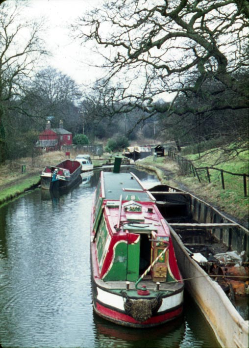
The date I have for the second photo is 1975, the only other photo at Skipton taken at the time shows Ouse tied up. There are several of Irwell in 1973, when it was first used for camping.
-
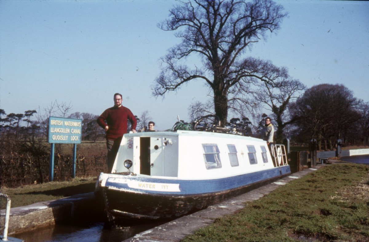
These are a couple of Geoff Wheat's photos showing locks on the Llangollen branch. The first is from 1964, the second from 1967. Both show top gate paddles.
-
The original bow cabin was probably removed when the Jones crane was installed. The new cabin is smaller, though the original 'base' seems to have survived.
-
A couple from circa 1975, when Ouse was based in the Skipton area. The first by Roger Lorenz, the second by Geoff Wheat.
-
Ouse was one of two boats built for Canal Transport Ltd by Harkers of Knottingley in 1934, the other being Calder. They had 26 new steel boats between 1932 and 1954, the others were built at Yarwoods (12) or Pimblotts (9), both in Northwich, with the final three at Harland & Wolff on the Thames. Those built before nationalisation were named after rivers, with the six built subsequently named after Lancashire towns. Canal Transport Ltd also had a fleet of wooden boats, the ones they had built, rather than the ones they took over in 1930, were named after planets, stars and rivers, with a few other names, usually reusing older names as boats were motorised. The final, post-nationalisation, wooden boats were named after Yorkshire towns. The L&LC Society does have a few copies of Geoff Wheat's book, Canal Transport Ltd, for sale at £3 plus postage, or available direct when Kennet is open.
-
As one of CRT's charitable aims is to maintain the heritage of our waterway system, and as, historically, boats would move regularly, surely requiring boats to move on after 14 days is actually maintaining the heritage of waterways, and thus addressing part of CRT's charitable aims.
-
 1
1
-
-
I did suggest that there were other reasons for having changeline bridges, but the canal crossing a watershed is not a reason usually considered, despite it being a major factor in determining their use. Other reasons could include the demands of landowners. The L&LC line at Church was changed after agreement with the Petre family at Dunkenhalgh, who insisted that the towpath be on the opposite side to their house to reduce the possibility of poaching etc on their lands. However, the towpath was almost always placed on the 'lower' side of the canal as this kept the land required to a minimum, with the towpath sitting on top of the embankment which retained the water, rather than on additional undisturbed land on the 'upper' side of the canal which would have required purchasing. On long levels, they may have been used to allow some respite for the horse, the load being transferred to the opposite shoulder when the towpath changed sides. Their use on the Macclesfield may also have arisen from this requirement as it is a comparatively late canal, and by the time it was built, the problems in operating with horses, and the associated economics, may have been better understood than on the first generation of canals.
-
It doesn't mention that I am giving a talk in the Archives of Saturday about heritage on the L&LC, nor that the short boat Kennet will be open for visitors.
-
As canals are often/usually built along a hillside, the towpath is usually on the 'lower' side of a canal, looking in cross section. So that when crossing the watershed, the towpath will usually change from one side of the canal to the other, and changeline/turnover bridges often mark where a canal is crossing a watershed. Between East Marton and Barrowford, the L&LC crosses from the Aire into the Ribble, then back into the Aire and then back again into the Ribble watershed, so there are two changeline bridges, below Greenberfield and at Barnoldswick, with Foulridge Tunnel acting as the third.
-
Checking the material in York City Archives, Acc183/218 are the River Engineers papers and correspondence, which includes 'specifications of vessels, cranes and other machinery'. The dates for the whole section are 1887-1970.
-
The Newark Heritage Barge people are probably the best source of information for Watsons. The York archives also have quite a lot of material about maintaining the river, so there could be information about your boat within the minutes.
-
4700 miles according to an IWA excercise:
https://www.waterways.org.uk/downloads/iwa_directory_to_the_inland_waterways_of_great_britain_100516
Tim
I did an historical review of the length of inland waterway for BW in 2000. It does depend upon what you call a navigable waterway, but my figures suggested that the maximum length was 4372.375 miles in 1849.
-
Not 'This Day', but 'This Year' is the 70th anniversary of Kennet entering service. Kennet is currently at Ellesmere Port, and will be open during the Working Boat event at Easter, - for those who want to see inside a proper boat. I will be giving a talk one day in the Waterways Archive, where there will hopefully be a display of Canal Transport Limited material, some relating to Kennet.
-
I read somewhere (maybe even here) that the lock was originally built on wooden piles with a wooden floor, which has failed. If you put gates on and tried to fill it, the water would just flow out underneath.....
MP.
Lower gates are not usually badly affected by the wooden floor/piles construction, as it is the head of the chamber that is damaged by water exiting through the ground paddles, as this photo of one of the Yorkshire L&LC locks shows. However, the Dee is now probably flowing faster than when the lock was built, resulting in the bed of the river being scoured, and this could have created problems by lowering the water table around the lock. For those interested in canal building, I am currently translating the section on lock floors in a 200-year-old Austrian book on canal construction, and hope to have the translated book ready for publication by the end of the year.
-
There are a few old craftsmen still painting modern 'stuff'. This is the work of Sam Yates, who served his time boatbuilding at Whitebirk.
-
This schematic map was published in 1905, and shows most of the waterways associated with the Po and Venice area.
-
Although CRT's property portfolio does need some amendments, I worry that it often sends out the wrong message. The problem stems from the way the government hived off canals into the charitable sector, with two distinctly different parts to the charity. One looks after navigation, heritage, and the like, and the second is the property sector, which is charged with generating the income to support the first. Unfortunately, the latter does things which are not really compatible with the charitable aims of the former. The property section is now selling off heritage sites. For example, the listed warehouses at Eanam and Skipton are both up for sale, despite the latter having been almost continually occupied and providing the Trust with a long term income. How can the navigation/heritage sector of CRT encourage people to support them financially, when the property sector is selling off heritage properties? It is a problem forced on CRT by a government too interested in its short-term political aims, without really understanding the damage it is doing to the long-term survival of waterways. There is no clear overall management of the two CRT sectors, with one doing things without proper consultation with the other, not a good management plan, but one which I am sure the present government is happy to have, as long as it doesn't cost them anything in the short-term.
-
Incidentally, if one looks for canals that were regularly navigated by powered pleasure boats after 1946, but are not now navigable, the only candidates I can think of are Runcorn Locks (and Hulme Lock), the Dee Locks branch (I went down this in 1973), and....can't think of others. A few stubs and diverted lines here and there, and the odd basin. I know that, in the Midlands, Bradley Locks, the Cannock Extension and Hatherton Branch, Tipton Green and Toll End Locks, Fens branch and Stourbridge Extension, and maybe the Haines branch, saw the odd pleasure boat, but none on a regular basis. And maybe the Black Bear Canal in Warrington? Possibly the first short length of the Hollinwood branch of the Ashton Canal, in Droylesden, may have seen a pleasure boat?
There may be some glaring omissions from that list, but that's all I can think of. I'd be very interested if anyone can think of others.
Bye for now
Joseph
I would add the Lancaster, as I remember talking to Oswald ? who was living on Stork at Burscough in the early 1970s, and he moved, with a different boat, onto the L&LC after the upper end of the Lancaster closed. He thought he was the last boater to use Tewitfield Locks.
-
I wonder if they have considered painting "NO STEP" at intervals along the offside 'non-towpath'? It seems to work for aircraft wings, and would be analogous to "MIND THE GAP" on railway platforms.
Would 'MIND THE DROP' be better?
-
Perhaps we should be doing more to promote canals which have not been closed. One reason I set up the L&LC Society was that the traditions and heritage of that canal were being forgotten. It was also suffering from decreasing maintenance standards possibly because money in the north west was being put towards the Rochdale and Huddersfield Narrow. Given government attitudes to financing canals, it is going to be hard enough keeping what we have in good order. It is good that waterways are being restored, but they do need additional money for maintenance in the long term, otherwise standards on the existing network will decline.
-
1
-
-
At Dutton circa 1972 when owned by Mike Sampson IIRC, and not in particularly good condition as regular pumping was one of our duties at the dock.
-
You will find difficulty on the C&HN and A&CN, where the towpath is non-existent in some places. There used to be ferries for boat horses, where the towpath changed sides on the rivers. Not surprisingly, these are no longer in operation. Probably best to go by train, or use the roads, to Leeds.


Waterways History Conference
in History & Heritage
Posted
The Railway & Canal Historical Society are running its 9th Waterways History Conference in Birmingham, to which anyone interested is invited. The cost is £22, including coffee and lunch.There is a booking form at http://www.rchs.org.uk/wp-content/uploads/2017/01/9WHC-booking-form.pdf.
Waterways History Conference – Birmingham University, 24th June 2017
The programme for the Conference, which runs from 10.00 to 16.30 and will be chaired by Tony Hirst OBE, is:
‘Developing a Research Agenda for Inland Waterways History’ – Dr Paul Sillitoe
‘Why Canal History Matters’ - Dr Jodie Matthews
‘Discovering waterway history through records, photographs and publications’ – Ray Shill
‘George Jebb, railway and canal engineer’- Prof Timothy Peters.
‘Waterways Family Research’ – Lorna York
‘Understanding early English canal technology - an Austrian view’ – Mike Clarke
‘Artefacts in Research’ – Zofia Kufeldt, NWM
‘The Cong Canal’ – Brian Goggin
… as well as a set of summaries of on-going research. There will also be a plenary discussion of the possible ways ahead for waterways history research, to which everyone will have the opportunity to contribute.